Kongens Lyngby

Lyngby Church
Kongens Lyngby ([ˈkʌŋəns ˈlyːŋby], Danish for "the King's Heather Town"; short form Lyngby) is the seat and commercial centre of Lyngby-Taarbæk Municipality in the northern suburbs of Copenhagen, Denmark. Lyngby Hovedgade is a busy shopping street and the site of a branch of Magasin du Nord as well as Lyngby Storcenter. The district is also home to several major companies, including COWI A/S, Bang & Olufsen, ICEpower a/s and Microsoft.
Lyngby station is located on the Hillerød radial of Copenhagen's S-train network.
Kongens Lyngby borders: Brede; the municipality of Gentofte (the most affluent in Denmark); Sorgenfri, where the Danish Prime Minister's official residence, Marienborg, lies; and the Gladsaxe municipality.
Contents
1 History
2 Shopping
3 Notable people
4 See also
5 References
6 External links
History
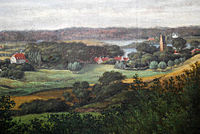
Kongens Lyngby in c. 1820 with the White Mansion visible on the left
The name Kongens Lyngby is first recorded in 1893. At that time large parts of North Zealand belonged to the Catholic Church (represented by Roskilde Cathedral and the name Lyngby was associated with several places. Store Lyngby belonged to Arresø church. "Our" Lyngby, on the other hand, was crown land. It may therefore have been to distinguish it from these other places that the name emerged.[1]
The original Lyngby village is now known as Bondebyen. Kongens Lyngby was also the site of a watermill, Lyngby Watermill, which is first mentioned in 1492 but is probably several hundred years older.
A royal road, Lyngby Kongevej, was created in 1584 to provide an easy link between Copenhagen and Frederick's new Frederiksborg Castle from where it was later extended to Fredensborg and Helsingør. It was the first of a number of royal roads created by Frederick II and his successor Christian IV.[2]

Scene from Kongens Lyngby, 1810, painting by Christoffer Wilhelm Eckersberg
In the 18th century, a growing number of country houses were built in the area by civil servants and merchants from Copenhagen. Kongens Lyngby had no market rights but developed into a local service centre with an increasing number of craftsmen and merchants.[3]

Lyngby Main Street in c. 1900
The North Line came to Lyngby in 1863 and was extended to Helsingør in 1864,This enabled citizens from Copenhagen to settle permanently in the area.Several factories opened in the area, including Christian Hasselbalck's curtain factory in 1892 which later became the town's largest employer.
In the 1930s, Kongens Lyngby developed into a modern suburb. The North Line was converted into an S-train line with more stations and Kongens Lyngby gradually merged with the neighboring settlements.
Shopping
Kongens Lyngby is the important shopping destination in the northern suburbs. Lyngby Hovedgade is a busy shopping site and is the site of a Magasin du Nord as well as Lyngby Storcenter.
Notable people
Jeanette Ottesen (born 1987), swimmer
Lars Von Trier (born 1956), director
See also
- Lyngby station
- Open Air Museum (Kongens Lyngby)
References
^ "Sorgenfri Castle". lyngbyok.dk. Retrieved 21 February 2017..mw-parser-output cite.citation{font-style:inherit}.mw-parser-output q{quotes:"""""""'""'"}.mw-parser-output code.cs1-code{color:inherit;background:inherit;border:inherit;padding:inherit}.mw-parser-output .cs1-lock-free a{background:url("//upload.wikimedia.org/wikipedia/commons/thumb/6/65/Lock-green.svg/9px-Lock-green.svg.png")no-repeat;background-position:right .1em center}.mw-parser-output .cs1-lock-limited a,.mw-parser-output .cs1-lock-registration a{background:url("//upload.wikimedia.org/wikipedia/commons/thumb/d/d6/Lock-gray-alt-2.svg/9px-Lock-gray-alt-2.svg.png")no-repeat;background-position:right .1em center}.mw-parser-output .cs1-lock-subscription a{background:url("//upload.wikimedia.org/wikipedia/commons/thumb/a/aa/Lock-red-alt-2.svg/9px-Lock-red-alt-2.svg.png")no-repeat;background-position:right .1em center}.mw-parser-output .cs1-subscription,.mw-parser-output .cs1-registration{color:#555}.mw-parser-output .cs1-subscription span,.mw-parser-output .cs1-registration span{border-bottom:1px dotted;cursor:help}.mw-parser-output .cs1-hidden-error{display:none;font-size:100%}.mw-parser-output .cs1-visible-error{font-size:100%}.mw-parser-output .cs1-subscription,.mw-parser-output .cs1-registration,.mw-parser-output .cs1-format{font-size:95%}.mw-parser-output .cs1-kern-left,.mw-parser-output .cs1-kern-wl-left{padding-left:0.2em}.mw-parser-output .cs1-kern-right,.mw-parser-output .cs1-kern-wl-right{padding-right:0.2em}
^ "Kongeveje" (in Danish). Gyldendal. Retrieved 21 July 2015.
^ "Kommunens historie" (in Danish). Lyngby-Taarbæk Kommune. Retrieved 16 February 2017.
External links
| Wikimedia Commons has media related to Kongens Lyngby. |
| Wikivoyage has a travel guide for Lyngby. |
Coordinates: 55°46′30.0″N 12°30′07.0″E / 55.775000°N 12.501944°E / 55.775000; 12.501944


