Moneta, Wyoming
Moneta, Wyoming | |
|---|---|
Unincorporated community | |
 Moneta Show map of Wyoming  Moneta Show map of the US | |
| Coordinates: 43°09′42″N 107°43′29″W / 43.16167°N 107.72472°W / 43.16167; -107.72472Coordinates: 43°09′42″N 107°43′29″W / 43.16167°N 107.72472°W / 43.16167; -107.72472 | |
| Country | United States |
| State | Wyoming |
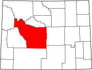
| County | Fremont |
| Elevation | 5,440 ft (1,660 m) |
| Time zone | UTC-7 (Mountain (MST)) |
| • Summer (DST) | UTC-6 (MDT) |
| Area code(s) | 307 |
GNIS feature ID | 1609126[1] |
Moneta is an unincorporated community in Fremont County, Wyoming, United States. Moneta is located on U.S. Route 26 20.1 miles (32.3 km) east-southeast of Shoshoni. It is also located close to the geographic center of the state.
History
Moneta was laid out in 1906.[2] It was named after Moneta, Iowa.[2] A post office was established in Moneta in 1906, and remained in operation until it was discontinued in 1972.[3]
In 2002, the vehicle in the "Lil' Miss murder" was uncovered in Moneta after DNA evidence linked the landowner, Dale Wayne Eaton, to the murder of Lisa Kimmell.[4] Following a civil suit in which Eaton's land was given to Kimmell's parents, the buildings on the property were burned to the ground.[5]
References
^ "Moneta". Geographic Names Information System. United States Geological Survey..mw-parser-output cite.citation{font-style:inherit}.mw-parser-output q{quotes:"""""""'""'"}.mw-parser-output code.cs1-code{color:inherit;background:inherit;border:inherit;padding:inherit}.mw-parser-output .cs1-lock-free a{background:url("//upload.wikimedia.org/wikipedia/commons/thumb/6/65/Lock-green.svg/9px-Lock-green.svg.png")no-repeat;background-position:right .1em center}.mw-parser-output .cs1-lock-limited a,.mw-parser-output .cs1-lock-registration a{background:url("//upload.wikimedia.org/wikipedia/commons/thumb/d/d6/Lock-gray-alt-2.svg/9px-Lock-gray-alt-2.svg.png")no-repeat;background-position:right .1em center}.mw-parser-output .cs1-lock-subscription a{background:url("//upload.wikimedia.org/wikipedia/commons/thumb/a/aa/Lock-red-alt-2.svg/9px-Lock-red-alt-2.svg.png")no-repeat;background-position:right .1em center}.mw-parser-output .cs1-subscription,.mw-parser-output .cs1-registration{color:#555}.mw-parser-output .cs1-subscription span,.mw-parser-output .cs1-registration span{border-bottom:1px dotted;cursor:help}.mw-parser-output .cs1-hidden-error{display:none;font-size:100%}.mw-parser-output .cs1-visible-error{font-size:100%}.mw-parser-output .cs1-subscription,.mw-parser-output .cs1-registration,.mw-parser-output .cs1-format{font-size:95%}.mw-parser-output .cs1-kern-left,.mw-parser-output .cs1-kern-wl-left{padding-left:0.2em}.mw-parser-output .cs1-kern-right,.mw-parser-output .cs1-kern-wl-right{padding-right:0.2em}
^ ab Chicago and North Western Railway Company (1908). A History of the Origin of the Place Names Connected with the Chicago & North Western and Chicago, St. Paul, Minneapolis & Omaha Railways. p. 104.
^ "Fremont County". Jim Forte Postal History. Retrieved 23 March 2015.
^ TARA WESTREICHER, Caspar Star-Tribune. "Murder charge filed in 'Lil Miss' killing". Retrieved 12 October 2018.
^ ANTHONY LANE, Casper Star-Tribune. "Murder victim's parents watch killer's house burn". Retrieved 12 October 2018.
This article about a location in Wyoming is a stub. You can help Wikipedia by expanding it. |
