Oki Islands
| Native name: 隠岐諸島 | |
|---|---|
 | |
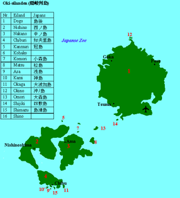 Map of the Oki Islands | |
| Geography | |
| Coordinates | 36°10′16.1″N 133°8′40.8″E / 36.171139°N 133.144667°E / 36.171139; 133.144667Coordinates: 36°10′16.1″N 133°8′40.8″E / 36.171139°N 133.144667°E / 36.171139; 133.144667 |
| Adjacent bodies of water | Sea of Japan |
| Total islands | 4 main, 16 named, 180+ total |
| Area | 346.1 km2 (133.6 sq mi) |
| Administration | |
Japan | |
| Prefectures | Shimane |
| District | Oki District |
| Demographics | |
| Population | 24,500 (2010) |
| Pop. density | 70.7 /km2 (183.1 /sq mi) |
| Ethnic groups | Japanese |
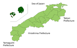
Oki Islands (隠岐諸島, Oki-shotō, or 隠岐の島 Oki-no-shima, 隠岐群島 Oki-guntō) is an archipelago in the Sea of Japan, the islands of which are administratively part of Oki District, Shimane Prefecture, Japan. The islands have a total area of 346.1 square kilometres (133.6 sq mi). Only four of the sixteen named islands are permanently inhabited. Much of the archipelago is within the borders of Daisen-Oki National Park. Due to their geological heritage, the Oki Islands were designated a UNESCO Global Geopark in September 2014.[1]
Contents
1 Geology
2 Climate
3 History
4 Administration
5 Transportation
6 Main islands
7 References
8 External links
Geology

Sekiheki volcanic cliff, Chiburijima.

Dozen Caldera seen from Mt. Akahage, Chiburijima
The Oki Islands are volcanic in origin, and are the exposed eroded summits of two massive stratovolcanoes dating approximately 5 million years ago to the Tertiary and Quaternary periods. The oldest rocks in Japan have been found on the Oki Islands.
Dōgo to the east is the largest island in area, and has the highest elevation, Mount Daimanji, at 608 metres (1,995 ft) above sea level. The Dōzen group of islands to the west are all portions of single ancient volcanic caldera which collapsed, leaving three large islands (Nishinoshima, Nakanoshima and Chiburijima) and numerous smaller islands and rocks in a ring formation surrounding a central lagoon.[2]
The archipelago is approximately 80 kilometres (43 nmi) north of Honshu coast at its closest point.
For administrative purposes, the Japanese government officially considers the disputed islet of Liancourt Rocks (Dokdo or Takeshima) to be a part of the town of Okinoshima on Dōgo.
Climate
| Chibu | ||||||||||||||||||||||||||||||||||||||||||||||||||||||||||||
|---|---|---|---|---|---|---|---|---|---|---|---|---|---|---|---|---|---|---|---|---|---|---|---|---|---|---|---|---|---|---|---|---|---|---|---|---|---|---|---|---|---|---|---|---|---|---|---|---|---|---|---|---|---|---|---|---|---|---|---|---|
| Climate chart (explanation) | ||||||||||||||||||||||||||||||||||||||||||||||||||||||||||||
| ||||||||||||||||||||||||||||||||||||||||||||||||||||||||||||
| ||||||||||||||||||||||||||||||||||||||||||||||||||||||||||||
- Summers (June–August) average around 30 degrees Celsius plus humidity. There usually is a strong sea breeze. The sea waves during the summer rarely exceed 2 meters.
- Autumn (September–November) is temperate. It begins to rain more often and the waves begin to grow. The Rainbow ferry stops operating in November.
- Winters (December to the end of February) are relatively mild. Temperatures rarely drop below freezing. Also, due to the warming influence of the sea, Oki does not get much snow. What snow there is does not lie for long because the ground is not cold enough. The ferry is more likely to be canceled due to high waves, but it is still possible to leave the island.
- Spring (March–May) is generally regarded as the best season. There are many opportunities for viewing cherry blossoms on Oki during the spring. The Rainbow ferry starts running in March.
History

A Japanese map dating from 1724, with the Oki Islands at the lower right, Liancourt Rocks in the center, and Ulleungdo on the left
The Oki Islands have been inhabited since the Japanese Paleolithic era, and numerous artifacts from the Jōmon, Yayoi and Kofun periods have been found by archaeologists, indicating continuous human occupation and activity.
The island were organized as Oki Province under the Ritsuryō reforms in the latter half of the seventh century, and the name “Oki-no-kuni” appears on wooden markers found in the imperial capital of Nara. The island of Dōgo is mentioned in the Nara period chronicles Kojiki and Nihon Shoki, and Dōgo Island was the location of the capital of ancient Oki Province.
During the late Heian period, due to its remoteness, Oki Province came to known as a place for political exile. In 1221, Emperor Go-Toba was sent to Oki, and died in exile on the islands;[4] In 1332, Emperor Go-Daigo was also sent in exile to Oki, but later managed to escape and regain control of the country.[5][6]
From the Kamakura period Oki Province was governed primarily by the shugo of Izumo Province. In the Muromachi period, it was ruled successively by the Sasaki clan, the Yamana clan and the Kyōgoku clan. In the Sengoku period the Amago clan held this province. After the Amago fell and the Tokugawa shogunate was established, Oki Province was declared a tenryō dominion under the direct control of the shōgun. The daimyō of Matsue Domain, belonging to the Matsudaira clan, was appointed as governor.
The entire province had an assessed revenue of only 18,000 koku, although its actual revenues were closer to only 12,000 koku. The province was a frequent port of call for the Kitamaebune coastal trading ships during the Edo period.
Following the Meiji Restoration, Oki Province became "Oki Prefecture" from February to June 1869. It was then attached to Tottori Prefecture until 1876, when it was transferred to Shimane Prefecture.[7]
In 1892, Lafcadio Hearn visited the islands, spending a month there, and writing about his experiences in Glimpses of Unfamiliar Japan. Oki was visited by the American naturalist Charles Henry Gilbert in 1906.[8]
Administration
The population is approximately 24,500 inhabitants spread over the four municipalities of:
Okinoshima-chō (Okinoshima-town), includes all of Dōgo and the uninhabited islets of Okinashima, Obanashima, Tsunameshima, Shijikijima and Ombeshima, with a total population of approximately 17,000.
Chibu-son (Chibu-village), includes all of Chiburijima and the nearby uninhabited islets of Okagashima, Shimazujima, Asashima and Kamishima, with a total population of about 800.
Ama-chō (Ama-town), includes all of Nakanoshima and the nearby uninhabited islets of Omorijima and Matsushima, with a total population of about 2,600.
Nishinoshima-chō (Nishinoshima-town), includes all of Nishinoshima and nearby uninhabited islets of Hoshikamijima, Futamatajima and Okazuroshima, population about 3,900.[9]
Transportation
Oki Airport (airport code "OKI") lies on the southeastern part of Dōgo and provides air service to Osaka International Airport (Itami, "ITM") and Izumo Airport ("IZO").
The Oki islands can be reached by ferries from harbours like Sakaiminato, Shichirui and Kaga on the mainland. There are also frequent ferries operating between the Dōzen islands throughout the year.
Main islands
| Photo | Name | Kanji | Area [km²] | Population | highest point [m] | Peak | Coordinates |
|---|---|---|---|---|---|---|---|
Dōgo | 島後島 | 241.58 | 14,849 | 608 | Mount Daimanji | 36°14′N 133°17′E / 36.233°N 133.283°E / 36.233; 133.283 (Dōgo) | |
Nakanoshima | 中之島 | 32.21 | 2,400 | 164 | 36°5′N 133°06′E / 36.083°N 133.100°E / 36.083; 133.100 (Nakanoshima) | ||
Nishinoshima | 西ノ島 | 55.97 | 3,400 | 452 | Takuhiyama | 36°6′N 133°00′E / 36.100°N 133.000°E / 36.100; 133.000 (Nishinoshima) | |
Chiburijima | 知夫里島 | 13.7 | 650 | 325 | 36°1′N 133°02′E / 36.017°N 133.033°E / 36.017; 133.033 (Chiburijma) |
References
- National Geospatial Intelligence Agency (NGIA). Prostar Sailing Directions 2005 Japan Enroute. Prostar Publications (2005). .mw-parser-output cite.citation{font-style:inherit}.mw-parser-output q{quotes:"""""""'""'"}.mw-parser-output code.cs1-code{color:inherit;background:inherit;border:inherit;padding:inherit}.mw-parser-output .cs1-lock-free a{background:url("//upload.wikimedia.org/wikipedia/commons/thumb/6/65/Lock-green.svg/9px-Lock-green.svg.png")no-repeat;background-position:right .1em center}.mw-parser-output .cs1-lock-limited a,.mw-parser-output .cs1-lock-registration a{background:url("//upload.wikimedia.org/wikipedia/commons/thumb/d/d6/Lock-gray-alt-2.svg/9px-Lock-gray-alt-2.svg.png")no-repeat;background-position:right .1em center}.mw-parser-output .cs1-lock-subscription a{background:url("//upload.wikimedia.org/wikipedia/commons/thumb/a/aa/Lock-red-alt-2.svg/9px-Lock-red-alt-2.svg.png")no-repeat;background-position:right .1em center}.mw-parser-output .cs1-subscription,.mw-parser-output .cs1-registration{color:#555}.mw-parser-output .cs1-subscription span,.mw-parser-output .cs1-registration span{border-bottom:1px dotted;cursor:help}.mw-parser-output .cs1-hidden-error{display:none;font-size:100%}.mw-parser-output .cs1-visible-error{font-size:100%}.mw-parser-output .cs1-subscription,.mw-parser-output .cs1-registration,.mw-parser-output .cs1-format{font-size:95%}.mw-parser-output .cs1-kern-left,.mw-parser-output .cs1-kern-wl-left{padding-left:0.2em}.mw-parser-output .cs1-kern-right,.mw-parser-output .cs1-kern-wl-right{padding-right:0.2em}
ISBN 1577856511
^ http://www.globalgeopark.org/aboutGGN/list/Japan/8438.htm
^ 隠岐の島町ふるさと教育副教材集委員会, eds. (March 2007). ふるさと隠岐 (in Japanese).CS1 maint: Uses editors parameter (link)
^ JMA Ama Station
^ Mason, R.H.P. and J.G. Caiger. (1972). A History of Japan, p. 105.
^ Titsingh, Isaac. (1834). Annales des empereurs du japon, p. 287.
^ Sansom, George (1961). A History of Japan, 1334-1615. Stanford University Press. p. 10. ISBN 0804705259.
^ Shimane Prefecture - History Archived 2009-01-15 at the Wayback Machine.
^ HighBeam Research - Charles Henry Gilbert (1859-1928), naturalist-in-charge: the 1906 North Pacific expedition of the Steamer Albatross
^ 3 Archived 2008-02-06 at the Wayback Machine.
External links
| Wikimedia Commons has media related to Oki Islands. |
Wikisource has the text of the 1911 Encyclopædia Britannica article Oki. |
- Map of the Oki Islands
- View of the Oki Islands
- Oki Islands Tourism Association
- Japan National Tourist Organization site
- Daisen-Oki National Park
- Oki Islands Global Geopark
- Sightseeing Navigation in Shimane
Authority control |
|
|---|


