Amasya Province
Amasya Province Amasya ili | |
|---|---|
Province of Turkey | |
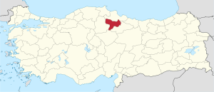 Location of Amasya Province in Turkey | |
| Country | Turkey |
| Region | West Black Sea |
| Subregion | Samsun |
| Government | |
| • Electoral district | Amasya |
| Area | |
| • Total | 5,520 km2 (2,130 sq mi) |
| Population (2010)[1] | |
| • Total | 326,351 |
| • Density | 59/km2 (150/sq mi) |
| Area code(s) | 0358 |
| Vehicle registration | 05 |
Amasya Province (Turkish: Amasya ili) is a province of Turkey, situated on the Yeşil River in the Black Sea Region to the north of the country.
Its provincial capital is Amasya, the antique Amaseia mentioned in documents from the era of Alexander the Great and the birthplace of the geographer and historian Strabo. In Ottoman times Amasya was well known for its madrassas, especially as a centre for the Khalwati Sufi order.
Contents
1 Geography
2 Districts
3 References
4 External links
Geography
Amasya, between the Black Sea and inner Anatolia, lies at the centre of a region of fertile plains crossed by the Yeşilırmak, Çekerek, and Tersakan rivers.Despite being near the Black Sea AmasYa has Hot summers and moderately cold winters. Amasya is an agricultural province known as the best apple growing province in the country, and also producing tobacco, peaches, cherries and okra.{[2]}
Districts
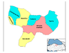
Amasya province is divided into 7 districts (capital district in bold):
- Amasya
- Göynücek
- Gümüşhacıköy
- Hamamözü
- Merzifon
- Suluova
- Taşova
References
^ Turkish Statistical Institute, MS Excel document – Population of province/district centers and towns/villages and population growth rate by provinces
^ "Amasya". Archived from the original on 2012-05-11. Retrieved 2012-05-14..mw-parser-output cite.citation{font-style:inherit}.mw-parser-output q{quotes:"""""""'""'"}.mw-parser-output code.cs1-code{color:inherit;background:inherit;border:inherit;padding:inherit}.mw-parser-output .cs1-lock-free a{background:url("//upload.wikimedia.org/wikipedia/commons/thumb/6/65/Lock-green.svg/9px-Lock-green.svg.png")no-repeat;background-position:right .1em center}.mw-parser-output .cs1-lock-limited a,.mw-parser-output .cs1-lock-registration a{background:url("//upload.wikimedia.org/wikipedia/commons/thumb/d/d6/Lock-gray-alt-2.svg/9px-Lock-gray-alt-2.svg.png")no-repeat;background-position:right .1em center}.mw-parser-output .cs1-lock-subscription a{background:url("//upload.wikimedia.org/wikipedia/commons/thumb/a/aa/Lock-red-alt-2.svg/9px-Lock-red-alt-2.svg.png")no-repeat;background-position:right .1em center}.mw-parser-output .cs1-subscription,.mw-parser-output .cs1-registration{color:#555}.mw-parser-output .cs1-subscription span,.mw-parser-output .cs1-registration span{border-bottom:1px dotted;cursor:help}.mw-parser-output .cs1-hidden-error{display:none;font-size:100%}.mw-parser-output .cs1-visible-error{font-size:100%}.mw-parser-output .cs1-subscription,.mw-parser-output .cs1-registration,.mw-parser-output .cs1-format{font-size:95%}.mw-parser-output .cs1-kern-left,.mw-parser-output .cs1-kern-wl-left{padding-left:0.2em}.mw-parser-output .cs1-kern-right,.mw-parser-output .cs1-kern-wl-right{padding-right:0.2em}
External links
(in English) Pictures of the city of Amasya
(in English) Amasya Weather Forecast Information
(in English) Amasya VR Photography
Amasya Province of Turkey | |||||||||||||||||||||||||||
|---|---|---|---|---|---|---|---|---|---|---|---|---|---|---|---|---|---|---|---|---|---|---|---|---|---|---|---|
| Districts |
|  | |||||||||||||||||||||||||
||
Metropolitan municipalities are bolded. | |||||||||||||||||||||||||||
| ||
Metropolitan municipalities are bolded. | ||
Coordinates: 40°41′59″N 35°41′11″E / 40.69972°N 35.68639°E / 40.69972; 35.68639
Authority control |
|
|---|
This geographical article about a location in Amasya Province, Turkey is a stub. You can help Wikipedia by expanding it. |


