Local government areas of Western Australia
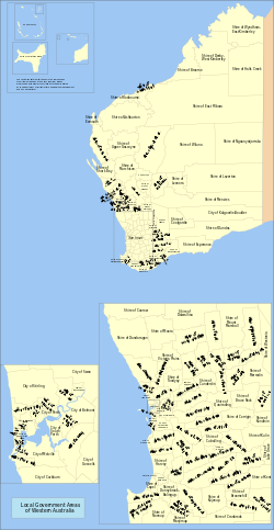
Map of local government areas in Western Australia
The local government areas (LGAs) in the Australian state of Western Australia describes the 139 institutions and processes by which towns and districts can manage their own affairs to the extent permitted by the Local Government Act 1995.[1] The Local Government Act 1995 also makes provision for regional local governments, established by two or more local governments for a particular purpose.[2]
There are three classifications of local government in Western Australia:
- City – predominantly urban, some larger regional centres
- Town – predominantly inner urban, plus Port Hedland
Shire – predominantly rural or outer suburban areas
The Shire of Christmas Island and the Shire of Cocos (Keeling) Islands are Federal external territories and covered by the Indian Ocean Territories Administration of Laws Act which allows the Western Australian Local Government Act to apply "on-Island" as though it were a Commonwealth act. Nonetheless, Christmas Island and the Cocos (Keeling) Islands are not part of Western Australia.
Historically, two types of local government existed – municipalities, which represented towns or condensed urban areas, and road districts, which represented all other regions. For instance, the Perth Road District was the precursor to the City of Stirling. Only a few cities – Perth, Fremantle, Subiaco, South Perth and Nedlands – existed prior to 1961. On 1 July 1961, all road districts became shires, and all municipalities became towns.
Contents
1 Metropolitan LGAs
2 Non-metropolitan LGAs
3 Regional local government organisations
4 References
5 External links
Metropolitan LGAs
| Local government area | Council seat[3] | Year est. | Land area | Population (2015)[4] | Notes | ||
|---|---|---|---|---|---|---|---|
km² | sq mi | Density | |||||
| Armadale, City of | Armadale | 1894 | 560 | 216 | 143 | 80,287 | Armadale-Kelmscott until 1979 |
| Bassendean, Town of | Bassendean | 1901 | 10 | 4 | 1,610 | 16,101 | West Guildford until 1922 |
| Bayswater, City of | Morley | 1897 | 33 | 13 | 2,136 | 70,472 | |
| Belmont, City of | Cloverdale | 1898 | 40 | 15 | 1,034 | 41,344 | |
| Cambridge, Town of | Floreat | 1994 | 22 | 8 | 1,284 | 28,250 | Split from Perth |
| Canning, City of | Cannington | 1907 | 65 | 25 | 1,513 | 98,355 | Placed under control of a Commissioner in 2012 |
| Claremont, Town of | Claremont | 1898 | 5 | 2 | 2,141 | 10,706 | |
| Cockburn, City of | Spearwood | 1871 | 168 | 65 | 641 | 107,645 | Fremantle RD until 1959 |
| Cottesloe, Town of | Cottesloe | 1895 | 4 | 2 | 2,151 | 8,602 | |
| East Fremantle, Town of | East Fremantle | 1897 | 3 | 1 | 2,581 | 7,743 | |
| Fremantle, City of | Fremantle | 1871 | 19 | 7 | 1,634 | 31,046 | |
| Gosnells, City of | Gosnells | 1907 | 127 | 49 | 985 | 125,051 | |
| Joondalup, City of | Joondalup | 1998 | 99 | 38 | 1,696 | 167,891 | Split from Wanneroo |
| Kalamunda, City of | Kalamunda | 1897 | 324 | 125 | 188 | 60,830 | Governed by commissioner until 1961 |
| Kwinana, City of | Kwinana Town Centre | 1954 | 120 | 46 | 310 | 37,149 | |
| Melville, City of | Ardross | 1900 | 53 | 20 | 2,012 | 106,655 | |
| Mosman Park, Town of | Mosman Park | 1899 | 4 | 2 | 2,387 | 9,547 | Split from Peppermint Grove RD. Buckland Hill RD 1899–1908, 1930–1937; Cottesloe Beach RD 1908–1930 |
| Mundaring, Shire of | Mundaring | 1903 | 644 | 249 | 62 | 40,015 | Greenmount until 1932 |
| Nedlands, City of | Nedlands | 1893 | 20 | 8 | 1,154 | 23,084 | Claremont RD until 1932 |
| Peppermint Grove, Shire of | Peppermint Grove | 1895 | 1 | 0 | 1,646 | 1,646 | |
| Perth, City of | Perth | 1856 | 20 | 8 | 1,054 | 21,092 | |
| Rockingham, City of | Rockingham | 1897 | 257 | 99 | 502 | 128,962 | |
| Serpentine-Jarrahdale, Shire of | Mundijong | 1894 | 905 | 349 | 23 | 21,162 | |
| South Perth, City of | South Perth | 1892 | 20 | 8 | 2,312 | 46,244 | |
| Stirling, City of | Stirling | 1871 | 105 | 41 | 2,167 | 227,566 | Shire of Perth until 1971 |
| Subiaco, City of | Subiaco | 1896 | 7 | 3 | 2,918 | 20,423 | |
| Swan, City of | Midland | 1871 | 1,044 | 403 | 128 | 133,303 | |
| Victoria Park, Town of | Victoria Park | 1994 | 18 | 7 | 2,136 | 38,450 | Split from Perth |
| Vincent, City of | Leederville | 1994 | 11 | 4 | 3,406 | 37,461 | Split from Perth |
| Wanneroo, City of | Wanneroo | 1902 | 686 | 265 | 275 | 188,785 | |
Non-metropolitan LGAs
| Local government area | Council seat[3] | Region | Year est. | Popn. (2013)[5] | Land area | Website | Notes | |
|---|---|---|---|---|---|---|---|---|
km² | sq mi | |||||||
| Albany, City of | Albany | Great Southern | 1998 | 36,262 | 4,310.5 | 1,664 | albany.wa.gov.au | Formerly: Town of Albany (1871) Shire of Albany (1871) |
| Ashburton, Shire of | Tom Price | Pilbara | 1972 | 10,959 | 202,325 | 78,118 | ashburton.wa.gov.au | West Pilbara until 1987. Formerly: Shire of Ashburton (1887) Shire of Tableland (1896) |
| Augusta–Margaret River, Shire of | Margaret River | South West | 1891 | 13,168 | 2,123 | 820 | amrsc.wa.gov.au | Augusta until 1926 |
| Beverley, Shire of | Beverley | Wheatbelt | 1871 | 1,566 | 2,372 | 916 | beverley.wa.gov.au | |
| Boddington, Shire of | Boddington | Peel | 1903 | 2,471 | 1,900 | 734 | boddington.wa.gov.au | Marradong until 1961 |
| Boyup Brook, Shire of | Boyup Brook | South West | 1896 | 1,738 | 2,827 | 1,092 | boyupbrook.wa.gov.au | Upper Blackwood until 1969 |
| Bridgetown-Greenbushes, Shire of | Bridgetown | South West | 1970 | 4,513 | 1,340 | 517 | bridgetown.wa.gov.au | Amalgamation of: Nelson RD (1887-1917), Bridgetown RD (1917-1961), Shire of Bridgetown (1961-1970); Greenbushes RD (1900-1961), Shire of Greenbushes (1961-1970) |
| Brookton, Shire of | Brookton | Wheatbelt | 1906 | 992 | 1,602 | 619 | brookton.wa.gov.au | |
| Broome, Shire of | Broome | Kimberley | 1918 | 17,251 | 54,632 | 21,094 | broome.wa.gov.au | |
| Broomehill-Tambellup, Shire of | Tambellup | Great Southern | 2007 | 1,167 | 2,610 | 1,008 | shirebt.wa.gov.au | Formerly: Shire of Broomehill (1892) Shire of Tambellup (1905) |
| Bruce Rock, Shire of | Bruce Rock | Wheatbelt | 1913 | 996 | 2,727 | 1,053 | brucerock.wa.gov.au | East Avon until 1918 |
| Bunbury, City of | Bunbury | South West | 1871 | 33,623 | 65 | 25 | bunbury.wa.gov.au | City in 1979 |
| Busselton, City of | Busselton | South West | 1951 | 34,290 | 1,455 | 562 | busselton.wa.gov.au | Amalgamation of Municipality and RD (both 1871) |
| Capel, Shire of | Capel | South West | 1894 | 16,447 | 558 | 215 | capel.wa.gov.au | Bunbury RD until 1907 |
| Carnamah, Shire of | Carnamah | Mid West | 1923 | 550 | 2,876 | 1,110 | carnamah.wa.gov.au | Split from Irwin and Mingenew |
| Carnarvon, Shire of | Carnarvon | Gascoyne | 1911 | 6,139 | 46,665 | 18,017 | carnarvon.wa.gov.au | Formerly: Town of Carnarvon (1891–1965) Lower Gascoyne RD (1887–1911) Minilya RD (1893–1911) Gascoyne-Minilya RD and Shire (1911-1965) |
| Chapman Valley, Shire of | Nabawa | Mid West | 1901 | 1,214 | 3,988 | 1,540 | chapmanvalley.wa.gov.au | Upper Chapman until 1958 |
| Chittering, Shire of | Bindoon | Wheatbelt | 1896 | 4,996 | 1,221 | 471 | chittering.wa.gov.au | |
| Christmas Island, Shire of | Christmas Island | 1992 | 1462 | 137 | 53 | shire.gov.cx | Federal external territory | |
| Cocos, Shire of | Home Island | 1992 | 605 | 14 | 5 | shire.cc | Federal external territory | |
| Collie, Shire of | Collie | South West | 1951 | 9,692 | 1,711 | 661 | collie.wa.gov.au | Amalgamation of Municipality (1901) and RD (1900) |
| Coolgardie, Shire of | Coolgardie | Goldfields | 1921 | 4,324 | 30,381 | 11,730 | coolgardie.wa.gov.au | Amalgamation of Municipality (1894) and RD (1896) |
| Coorow, Shire of | Coorow | Mid West | 1962 | 1,085 | 4,194 | 1,619 | coorow.wa.gov.au | Split from Carnamah |
| Corrigin, Shire of | Corrigin | Wheatbelt | 1913 | 1,099 | 2,682 | 1,036 | corrigin.wa.gov.au | |
| Cranbrook, Shire of | Cranbrook | Great Southern | 1926 | 1,101 | 3,278 | 1,266 | cranbrook.wa.gov.au | |
| Cuballing, Shire of | Cuballing | Wheatbelt | 1902 | 878 | 1,196 | 462 | cuballing.wa.gov.au | |
| Cue, Shire of | Cue | Mid West | 1912 | 298 | 13,607 | 5,254 | cue.wa.gov.au | Amalgamation of Day Dawn M. (1894) and Cue RD (1895) |
| Cunderdin, Shire of | Cunderdin | Wheatbelt | 1894 | 1,302 | 1,864 | 720 | cunderdin.wa.gov.au | Split from Northam, named Meckering until 1944 |
| Dalwallinu, Shire of | Dalwallinu | Wheatbelt | 1916 | 1,295 | 7,235 | 2,793 | dalwallinu.wa.gov.au | |
| Dandaragan, Shire of | Jurien Bay | Wheatbelt | 1890 | 3,325 | 6,718 | 2,594 | dandaragan.wa.gov.au | |
| Dardanup, Shire of | Eaton | South West | 1894 | 13,791 | 526 | 203 | dardanup.wa.gov.au | |
| Denmark, Shire of | Denmark | Great Southern | 1911 | 5,748 | 1,860 | 718 | denmark.wa.gov.au | |
| Derby-West Kimberley, Shire of | Derby | Kimberley | 1884 | 10,047 | 119,841 | 46,271 | sdwk.wa.gov.au | West Kimberley until 1983 |
| Donnybrook-Balingup, Shire of | Donnybrook | South West | 1970 | 5,753 | 1,561 | 603 | donnybrook-balingup.wa.gov.au | Formerly: Shire of Donnybrook, Preston RD until 1961 (1896) Shire of Balingup, Upper Capel RD until 1905 (1899) |
| Dowerin, Shire of | Dowerin | Wheatbelt | 1911 | 672 | 1,865 | 720 | dowerin.wa.gov.au | |
| Dumbleyung, Shire of | Dumbleyung | Wheatbelt | 1909 | 608 | 2,542 | 981 | dumbleyung.wa.gov.au] | |
| Dundas, Shire of | Norseman | Goldfields | 1929 | 1,182 | 92,656 | 35,775 | dundas.wa.gov.au | |
| East Pilbara, Shire of | Newman | Pilbara | 1972 | 12,960 | 372,301 | 143,746 | eastpilbara.wa.gov.au | Formerly: Shire of Marble Bar (1896) Shire of Nullagine (1898) |
| Esperance, Shire of | Esperance | Goldfields | 1895 | 14,242 | 45,059 | 17,397 | esperance.wa.gov.au | Absorbed municipality (1895–1908) |
| Exmouth, Shire of | Exmouth | Gascoyne | 1964 | 2,570 | 6,504 | 2,511 | exmouth.wa.gov.au | |
| Gingin, Shire of | Gingin | Wheatbelt | 1893 | 5,248 | 3,211 | 1,240 | gingin.wa.gov.au | Absorbed municipality (1893–1903) |
| Gnowangerup, Shire of | Gnowangerup | Great Southern | 1912 | 1,303 | 4,267 | 1,647 | gnowangerup.wa.gov.au | |
| Goomalling, Shire of | Goomalling | Wheatbelt | 1927 | 976 | 1,837 | 709 | goomalling.wa.gov.au | |
| Greater Geraldton, City of | Geraldton | Mid West | 2011 | 40,448 | 9,903 | 3,824 | cgg.wa.gov.au | Formerly: City of Geraldton (1871–2007) Shire of Greenough (1951–2007) Shire of Mullewa (1911–2011) |
| Halls Creek, Shire of | Halls Creek | Kimberley | 1887 | 3,940 | 133,061 | 51,375 | hcshire.wa.gov.au | Kimberley Goldfields until 1915 |
| Harvey, Shire of | Harvey | South West | 1894 | 25,924 | 1,729 | 668 | harvey.wa.gov.au | |
| Irwin, Shire of | Dongara | Mid West | 1871 | 3,780 | 2,375 | 917 | irwin.wa.gov.au | |
| Jerramungup, Shire of | Jerramungup | Great Southern | 1982 | 1,085 | 6,509 | 2,513 | jerramungup.wa.gov.au | Split from Gnowangerup |
| Kalgoorlie-Boulder, City of | Kalgoorlie | Goldfields | 1989 | 33,763 | 95,242 | 36,773 | kalbould.wa.gov.au | Formerly: Town of Kalgoorlie (1897–1989) Shire of Boulder (1969–1989) |
| Karratha, City of | Karratha | Pilbara | 1887 | 25,907 | 15,278 | 5,899 | karratha.wa.gov.au | Absorbed Roebourne and Cossack municipalities in 1910, was known as Shire of Roebourne until 2014 |
| Katanning, Shire of | Katanning | Great Southern | 1892 | 4,407 | 1,519 | 586 | katanning.wa.gov.au | |
| Kellerberrin, Shire of | Kellerberrin | Wheatbelt | 1908 | 1,227 | 1,917 | 740 | kellerberrin.wa.gov.au | |
| Kent, Shire of | Nyabing | Great Southern | 1922 | 528 | 5,631 | 2,174 | kent.wa.gov.au | Nyabing-Pingrup 1955–1972 |
| Kojonup, Shire of | Kojonup | Great Southern | 1871 | 2,022 | 2,932 | 1,132 | kojonup.wa.gov.au | |
| Kondinin, Shire of | Kondinin | Wheatbelt | 1925 | 1,042 | 7,427 | 2,868 | kondinin.wa.gov.au | |
| Koorda, Shire of | Koorda | Wheatbelt | 1927 | 431 | 2,835 | 1,095 | koorda.wa.gov.au | |
| Kulin, Shire of | Kulin | Wheatbelt | 1918 | 834 | 4,720 | 1,822 | kulin.wa.gov.au | Roe until 1926 |
| Lake Grace, Shire of | Lake Grace | Wheatbelt | 1922 | 1,370 | 11,892 | 4,592 | lakegrace.wa.gov.au | |
| Laverton, Shire of | Laverton | Goldfields | 1906 | 1,357 | 180,127 | 69,547 | laverton.wa.gov.au | Mount Margaret until 1950, absorbed Mount Morgans M (1900–1913) |
| Leonora, Shire of | Leonora | Goldfields | 1912 | 2,764 | 31,941 | 12,332 | leonora.wa.gov.au | |
| Mandurah, City of | Mandurah | Peel | 1949 | 80,683 | 174 | 67 | mandurah.wa.gov.au | City in 1990 |
| Manjimup, Shire of | Manjimup | South West | 1908 | 9,427 | 7,027 | 2,713 | manjimup.wa.gov.au | Warren until 1925 |
| Meekatharra, Shire of | Meekatharra | Mid West | 1909 | 1,521 | 100,327 | 38,736 | meekashire.wa.gov.au | |
| Menzies, Shire of | Menzies | Goldfields | 1912 | 422 | 124,794 | 48,183 | menzies.wa.gov.au | |
| Merredin, Shire of | Merredin | Wheatbelt | 1921 | 3,300 | 3,297 | 1,273 | merredin.wa.gov.au | |
| Mingenew, Shire of | Mingenew | Mid West | 1901 | 486 | 1,937 | 748 | mingenew.wa.gov.au | Upper Irwin until 1919 |
| Moora, Shire of | Moora | Wheatbelt | 1908 | 2,535 | 3,767 | 1,454 | moora.wa.gov.au | Split from Victoria Plains |
| Morawa, Shire of | Morawa | Mid West | 1928 | 906 | 3,517 | 1,358 | morawa.wa.gov.au | Split from Perenjori-Morawa RD |
| Mount Magnet, Shire of | Mount Magnet | Mid West | 1901 | 711 | 13,893 | 5,364 | mtmagnet.wa.gov.au | Absorbed municipality (1896–1901) |
| Mount Marshall, Shire of | Bencubbin | Wheatbelt | 1923 | 471 | 10,197 | 3,937 | mtmarshall.wa.gov.au | |
| Mukinbudin, Shire of | Mukinbudin | Wheatbelt | 1933 | 491 | 3,438 | 1,327 | mukinbudin.wa.gov.au | |
| Murchison, Shire of | Murchison | Mid West | 1875 | 127 | 45,110 | 17,417 | murchison.wa.gov.au | |
| Murray, Shire of | Pinjarra | Peel | 1887 | 16,304 | 1,711 | 661 | murray.wa.gov.au | |
| Nannup, Shire of | Nannup | South West | 1890 | 1,316 | 3,055 | 1,180 | nannup.wa.gov.au | Lower Blackwood until 1925 |
| Narembeen, Shire of | Narembeen | Wheatbelt | 1925 | 810 | 3,836 | 1,481 | narembeen.wa.gov.au | |
| Narrogin, Shire of | Narrogin | Wheatbelt | 1892 | 5,314 | 1,632 | 630 | narrogin.wa.gov.au | Absorbed Town of Narrogin (1906–2016) |
| Ngaanyatjarraku, Shire of | Warburton | Goldfields | 1,543 | 160,733 | 62,059 | ngaanyatjarraku.wa.gov.au | ||
| Northam, Shire of | Northam | Wheatbelt | 1871 | 11,730 | 1,432 | 553 | northam.wa.gov.au | Absorbed Town of Northam (1879–2007) |
| Northampton, Shire of | Northampton | Mid West | 1871 | 3,379 | 12,638 | 4,880 | northampton.wa.gov.au | Mines RD until 1887 |
| Nungarin, Shire of | Nungarin | Wheatbelt | 1921 | 228 | 1,164 | 449 | nungarin.wa.gov.au | |
| Perenjori, Shire of | Perenjori | Mid West | 1916 | 924 | 8,311 | 3,209 | perenjori.wa.gov.au | Perenjori-Morawa until 1928 |
| Pingelly, Shire of | Pingelly | Wheatbelt | 1891 | 1,195 | 1,295 | 500 | pingelly.wa.gov.au | Moorumbine until 1913 |
| Plantagenet, Shire of | Mount Barker | Great Southern | 1871 | 5,182 | 4,877 | 1,883 | plantagenet.wa.gov.au | |
| Port Hedland, Town of | Port Hedland | Pilbara | 1891 | 16,472 | 18,482 | 7,136 | porthedland.wa.gov.au | Pilbara until 1904. Town 1989 |
| Quairading, Shire of | Quairading | Wheatbelt | 1913 | 1,094 | 2,018 | 779 | quairading.wa.gov.au | Avon until 1922 |
| Ravensthorpe, Shire of | Ravensthorpe | Goldfields | 1900 | 2,288 | 9,833 | 3,797 | ravensthorpe.wa.gov.au | Phillips River until 1961 |
| Sandstone, Shire of | Sandstone | Mid West | 1897 | 116 | 32,714 | 12,631 | sandstone.wa.gov.au | Black Range until 1961 |
| Shark Bay, Shire of | Denham | Gascoyne | 1904 | 928 | 24,184 | 9,337 | sharkbay.wa.gov.au | |
| Tammin, Shire of | Tammin | Wheatbelt | 1948 | 401 | 1,103 | 426 | tammin.wa.gov.au | Split from Cunderdin |
| Three Springs, Shire of | Three Springs | Mid West | 1928 | 632 | 2,656 | 1,025 | threesprings.wa.gov.au | |
| Toodyay, Shire of | Toodyay | Wheatbelt | 1912 | 4,886 | 1,693 | 654 | toodyay.wa.gov.au | Amalgamation of Newcastle M (1877) and Toodyay RD (1871) |
| Trayning, Shire of | Trayning | Wheatbelt | 1911 | 342 | 1,652 | 638 | trayning.wa.gov.au | |
| Upper Gascoyne, Shire of | Gascoyne Junction | Gascoyne | 1887 | 262 | 58,007 | 22,397 | uppergascoyne.wa.gov.au | |
| Victoria Plains, Shire of | Calingiri | Wheatbelt | 1871 | 921 | 2,553 | 986 | victoriaplains.wa.gov.au | |
| Wagin, Shire of | Wagin | Wheatbelt | 1887 | 1,975 | 1,947 | 752 | wagin.wa.gov.au | Arthur until 1905. Absorbed municipality (1906–1961) |
| Wandering, Shire of | Wandering | Wheatbelt | 1874 | 438 | 1,901 | 734 | wandering.wa.gov.au | |
| Waroona, Shire of | Waroona | Peel | 1898 | 3,843 | 832 | 321 | waroona.wa.gov.au | Drakesbrook until 1961 |
| West Arthur, Shire of | Darkan | Wheatbelt | 1896 | 887 | 2,834 | 1,094 | westarthur.wa.gov.au | |
| Westonia, Shire of | Westonia | Wheatbelt | 1916 | 272 | 3,316 | 1,280 | westonia.wa.gov.au | |
| Wickepin, Shire of | Wickepin | Wheatbelt | 1909 | 750 | 2,041 | 788 | wickepin.wa.gov.au | |
| Williams, Shire of | Williams | Wheatbelt | 1871 | 928 | 2,306 | 890 | williams.wa.gov.au | |
| Wiluna, Shire of | Wiluna | Mid West | 1909 | 1,279 | 181,662 | 70,140 | wiluna.wa.gov.au | |
| Wongan-Ballidu, Shire of | Wongan Hills | Wheatbelt | 1887 | 1,586 | 3,368 | 1,300 | wongan.wa.gov.au | Melbourne until 1926 |
| Woodanilling, Shire of | Woodanilling | Great Southern | 1906 | 429 | 1,129 | 436 | woodanilling.wa.gov.au | |
| Wyalkatchem, Shire of | Wyalkatchem | Wheatbelt | 1920 | 519 | 1,596 | 616 | wyalkatchem.wa.gov.au | |
| Wyndham East Kimberley, Shire of | Kununurra | Kimberley | 1887 | 8,652 | 112,023 | 43,252 | swek.wa.gov.au | East Kimberley until 1896, Wyndham until 1961 |
| Yalgoo, Shire of | Yalgoo | Mid West | 1907 | 445 | 27,976 | 10,802 | yalgoo.wa.gov.au | Upper Murchison until 1912 |
| Yilgarn, Shire of | Southern Cross | Wheatbelt | 1891 | 1,698 | 30,405 | 11,739 | yilgarn.wa.gov.au | Absorbed Southern Cross M (1892–1918) |
| York, Shire of | York | Wheatbelt | 1871 | 3,581 | 2,133 | 824 | york.wa.gov.au | Absorbed Town of York (1871–1965) |
Regional local government organisations
- Bunbury Harvey Regional Council, comprising the LGAs of City of Bunbury and Shire of Harvey[6]
- Eastern Metropolitan Regional Council, comprising the LGAs of Town of Bassendean, City of Bayswater, City of Belmont, City of Kalamunda, Shire of Mundaring and City of Swan[7]
- Mindarie Regional Council, comprising the LGAs of Town of Cambridge, City of Joondalup, City of Perth, City of Stirling, Town of Victoria Park, City of Vincent and City of Wanneroo[8]
- Murchison Regional Vermin Council, comprising the LGAs of Shire of Cue, Shire of Meekatharra, Shire of Mount Magnet, Shire of Sandstone and Shire of Yalgoo[9]
- Pilbara Regional Council, comprising the LGAs of Shire of Ashburton, Shire of East Pilbara, City of Karratha and Town of Port Hedland[10]
- Rivers Regional Council, comprising the LGAs of City of Armadale, City of Gosnells, City of Mandurah, Shire of Murray, Shire of Serpentine-Jarrahdale and City of South Perth[11]
- Southern Metropolitan Regional Council, comprising the LGAs of City of Cockburn, Town of East Fremantle, City of Fremantle, City of Kwinana and City of Melville[12]
- Tamala Park Regional Council, comprising the LGAs of Town of Cambridge, City of Joondalup, City of Perth, City of Stirling, Town of Victoria Park, City of Vincent and City of Wanneroo[13]
- Western Metropolitan Regional Council, comprising the LGAs of Town of Claremont, Town of Cottesloe, Town of Mosman Park, Shire of Peppermint Grove and City of Subiaco[14]
References
^ "Local Government Act 1995". Retrieved 26 July 2011..mw-parser-output cite.citation{font-style:inherit}.mw-parser-output q{quotes:"""""""'""'"}.mw-parser-output code.cs1-code{color:inherit;background:inherit;border:inherit;padding:inherit}.mw-parser-output .cs1-lock-free a{background:url("//upload.wikimedia.org/wikipedia/commons/thumb/6/65/Lock-green.svg/9px-Lock-green.svg.png")no-repeat;background-position:right .1em center}.mw-parser-output .cs1-lock-limited a,.mw-parser-output .cs1-lock-registration a{background:url("//upload.wikimedia.org/wikipedia/commons/thumb/d/d6/Lock-gray-alt-2.svg/9px-Lock-gray-alt-2.svg.png")no-repeat;background-position:right .1em center}.mw-parser-output .cs1-lock-subscription a{background:url("//upload.wikimedia.org/wikipedia/commons/thumb/a/aa/Lock-red-alt-2.svg/9px-Lock-red-alt-2.svg.png")no-repeat;background-position:right .1em center}.mw-parser-output .cs1-subscription,.mw-parser-output .cs1-registration{color:#555}.mw-parser-output .cs1-subscription span,.mw-parser-output .cs1-registration span{border-bottom:1px dotted;cursor:help}.mw-parser-output .cs1-hidden-error{display:none;font-size:100%}.mw-parser-output .cs1-visible-error{font-size:100%}.mw-parser-output .cs1-subscription,.mw-parser-output .cs1-registration,.mw-parser-output .cs1-format{font-size:95%}.mw-parser-output .cs1-kern-left,.mw-parser-output .cs1-kern-wl-left{padding-left:0.2em}.mw-parser-output .cs1-kern-right,.mw-parser-output .cs1-kern-wl-right{padding-right:0.2em}
^ Refer Part 3 Division 4 of the "Local Government Act 1995". Retrieved 26 July 2011.
^ ab Department of Health. "Local Government contacts". Retrieved 26 July 2009.
^ "3218.0 – Regional Population Growth, Australia, 2014–15". Australian Bureau of Statistics. Retrieved 29 September 2016.
^ Australian Bureau of Statistics (3 April 2014). "Regional Population Growth, Australia, 2009–10 – Western Australia". Retrieved 13 June 2014.
^ "Bunbury Harvey Regional Council". Retrieved 19 April 2016.
^ "Eastern Metropolitan Regional Council". Retrieved 19 April 2016.
^ "Mindarie Regional Council". Retrieved 19 April 2016.
^ "Murchison Regional Vermin Council". Retrieved 3 August 2017.
^ "Pilbara Regional Council". Retrieved 19 April 2016.
^ "Rivers Regional Council". Retrieved 19 April 2016.
^ "Southern Metropolitan Regional Council". Retrieved 19 April 2016.
^ "Tamala Park Regional Council". Retrieved 19 April 2016.
^ "Western Metropolitan Regional Council". Retrieved 19 April 2016.
External links
"Shires of Australia". Statoids.
Politics of Australia | ||
|---|---|---|
| Commonwealth |
|  |
| Federal elections |
| |
| State/Territory governments |
| |
| State/Territory elections |
| |
| Local government |
| |
| Political parties |
| |
| Political terminology |
| |
Western Australia | ||
|---|---|---|
| General |
| |
| Regions |
| |
Cities and towns |
| |
Western Australia portal | ||


