List of contributing properties in the St. Anthony Falls Historic District
Saint Anthony Falls looking upstream

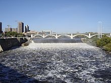
Saint Anthony Falls looking downstream
The following are the 85 contributing properties in the Saint Anthony Falls Historic District in Minneapolis, Minnesota, United States. About 56 still exist. The district's archaeological record is considered to be one of the most-endangered historic sites in Minnesota.[1]
Contents
1 Extant
2 Razed
3 See also
4 Notes
5 References
Extant

Pillsbury "A" Mill and Hennepin Island Hydroelectric Plant

Pillsbury "A" Mill

Stone Arch Bridge

Third Avenue Bridge

Washburn "A" Mill (right)
- Adams-Barquist House, 177 Nicollet St.
- Andrew and Ole Loberg House, 171 E. Island Ave.
- Andrew and Ole Loberg House, 175 E. Island Ave.
- Backe-Barquist House, 91 Nicollet St.
- Baker-Leber House, 95 W. Island Ave.
- Barquist-Holmberg House, 167-169 Nicollet St.
- Bridge No. L-8900
- Bridge No. L-9331
- Bridge No. L-9332
- Bridge No. L-9333
- Brookins, George, W., House, 163 Nicollet St.
- Crown Roller Mill, 105 5th Ave. S.
- Eastman Tunnel
- Falls of St. Anthony Dam
- Falls of St. Anthony Dike
- Falls of St. Anthony, East Channel Escarpment
- Griswold, Franklin G., House, 15-17 Maple Pl.
- Griswold, Franklin, G., House, 107-109 W. Island Ave.
- Grove St. Flats, 2-16 Grove St.
- Hall and Dann Barrel Company Factory, 111 3rd Ave. S.
- Harness Shop, 116 Hennepin Ave. E.
- Hennepin Island Hydroelectric Plant
- house, 27 Maple Pl.
- house, 18-20 Maple Pl.
- Humboldt Flour Mill
- John Mayell House (also listed as "Mayall, John, House"), 93 Nicollet St.
- Log Sluice
- Main Street Hydroelectric Station, 206 Main St. SE
- Martin and Morrison Block, 127-129 Main St. SE
- Meader-Farnham House, 103-105 W. Island Ave.
- Minneapolis Eastern Railway Company Engine House
- Minneapolis Flour Mill
- Murphy, Edward, House, 167-169 E. Island Ave.
- North Star Woolen Mill
- Northwestern Consolidated Milling Company Elevator A (Ceresota Building)
- O'Brien-Meyer House, 185-186 E. Island Ave.
- Our Lady of Lourdes Catholic Church
- Pease, R.M.S, House, 101 W. Island Ave.
- Pillsbury "A" Mill
- Pillsbury "A" Mill Transformer Building
- Pillsbury Industrial Equipment/ Pillsbury Machine Shop
- Pillsbury Warehouse #2
- Pracna Building
- Pye, James, House, 163 E. Island Ave.
- Russell's Planing Mill/ Model Mill/ King Midas Flour Mill
- Salisbury & Satterlee Company Complex
- St. Anthony Falls Hydroelectric Laboratory
- St. Anthony Falls Water Power Co. Canal/ Pillsbury Canal
- St. Anthony Falls Water Power Co. Tailrace/ Chute Tunnel
- Standard Flour Mill, 150 Portland Ave
- Stone Arch Bridge
- Third Avenue Bridge
- Upton Block/ Union Iron Works
- Washburn, Crosby & Company "A" Flour Mill (Washburn "A" Mill)
- Washburn-Crosby Company Elevator No. 2
- Washburn-Crosby Company Train Shed
- William D. Burnett Tenement, 111-113 W. Island Ave.
- Woodward Flat Duplex, 183-184 E. Island Ave.
- Woodward Flat Fourplex, 187-190 E. Island Ave.
Razed

Arctic, Union, Holly and Cataract flour mills

Minneapolis Boiler Works
- Alaska Flour Mill/ Pillsbury "B" Flour Mill
- Anchor Flour Mill
- Arctic Flour Mill/ St. Anthony Flour Mill
- Cataract Flour Mill
- Clapp Woolen Mill/ Empire Mill/ Pillsbury B Elevator
- Columbia Flour Mill
- First Bassett Sawmill/ Second City Waterworks
- First City Waterworks/ Holly Flour Mill
- Galaxy Flour Mill
- Minneapolis and St. Louis Railroad Wheelhouse
- Minneapolis Cotton Mill/ Excelsior Flour Mill
- Minneapolis Eastern Railroad Trestle Piers
- Minneapolis Mill Co. Gatehouse & Power Canal
- Minneapolis Paper Mill/ Pillsbury Warehouse C
- Northwestern Flour Mill
- Occidental Feed Mill
- Palisade Flour Mill
- People's Flour Mill
- Pettit Mill/ Northwestern Consolidated Elevator B
- Phoenix Flour Mill/ Pillsbury Rye Mill
- Pillsbury "A" Steam Power Plant
- Russell Mill/ Dakota Mill/ King Midas Flour Mill
- Second Bassett Sawmill
- Second East Side Platform Sawmills
- Union Flour Mill
- Washburn "B" Flour Mill Complex
- Washburn "C" Flour Mill Complex
- Zenith Flour Mill

See also
- Mill Ruins Park
Notes
^ "10 Most Endangered Places". Preservation Alliance of Minnesota. 2008. Retrieved 2018-01-20..mw-parser-output cite.citation{font-style:inherit}.mw-parser-output q{quotes:"""""""'""'"}.mw-parser-output code.cs1-code{color:inherit;background:inherit;border:inherit;padding:inherit}.mw-parser-output .cs1-lock-free a{background:url("//upload.wikimedia.org/wikipedia/commons/thumb/6/65/Lock-green.svg/9px-Lock-green.svg.png")no-repeat;background-position:right .1em center}.mw-parser-output .cs1-lock-limited a,.mw-parser-output .cs1-lock-registration a{background:url("//upload.wikimedia.org/wikipedia/commons/thumb/d/d6/Lock-gray-alt-2.svg/9px-Lock-gray-alt-2.svg.png")no-repeat;background-position:right .1em center}.mw-parser-output .cs1-lock-subscription a{background:url("//upload.wikimedia.org/wikipedia/commons/thumb/a/aa/Lock-red-alt-2.svg/9px-Lock-red-alt-2.svg.png")no-repeat;background-position:right .1em center}.mw-parser-output .cs1-subscription,.mw-parser-output .cs1-registration{color:#555}.mw-parser-output .cs1-subscription span,.mw-parser-output .cs1-registration span{border-bottom:1px dotted;cursor:help}.mw-parser-output .cs1-hidden-error{display:none;font-size:100%}.mw-parser-output .cs1-visible-error{font-size:100%}.mw-parser-output .cs1-subscription,.mw-parser-output .cs1-registration,.mw-parser-output .cs1-format{font-size:95%}.mw-parser-output .cs1-kern-left,.mw-parser-output .cs1-kern-wl-left{padding-left:0.2em}.mw-parser-output .cs1-kern-right,.mw-parser-output .cs1-kern-wl-right{padding-right:0.2em}
References
"St. Anthony Falls Historic District". Minnesota Historical Society (nrhp.mnhs.org). Retrieved 2007-07-25.


