New Mexico State Register of Cultural Properties
The New Mexico State Register of Cultural Properties is a register of historic and prehistoric properties located in the state of New Mexico. It is maintained by the New Mexico Historic Preservation Division of the New Mexico Department of Cultural Affairs. The Cultural Properties Review Committee meets at least six times a year. The committee lists properties in the State Register and forwards nominations to the National Register.[1]
Contents
1 Current listings
2 See also
3 References
4 External links
Current listings
Properties listed on the New Mexico State Register of Cultural Properties:[2]
| [3] | Name | Image | Location | County | Description |
|---|---|---|---|---|---|
| 21 | Salmon Ruins |  | 36°42′4″N 108°1′38″W / 36.70111°N 108.02722°W / 36.70111; -108.02722 (Salmon Ruins) | San Juan | Chacoan site located in northwest New Mexico |
| 30 | Trinity Site | 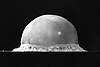 | 33°40′38″N 106°28′31″W / 33.67722°N 106.47528°W / 33.67722; -106.47528 (Trinity Site) | Socorro | Site of the first nuclear weapons test |
| 32 | Wagon Mound |  | 36°0′26″N 104°42′26″W / 36.00722°N 104.70722°W / 36.00722; -104.70722 (Wagon Mound) | Mora | Landmark on the Santa Fe Trail |
| 33 | Watrous/La Junta | 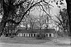 | 35°48′3″N 105°0′5″W / 35.80083°N 105.00139°W / 35.80083; -105.00139 (Watrous/La Junta) | Mora | Settlement at the junction of the Mountain and Cimarron Cutoff routes of the Santa Fe Trail |
| 35 | Fort Cummings | 32°27′56″N 107°38′45″W / 32.46556°N 107.64583°W / 32.46556; -107.64583 (Fort Cummings) | Luna | ||
| 36 | Fort Fillmore | 32°15′28″N 106°44′36″W / 32.25778°N 106.74333°W / 32.25778; -106.74333 (Fort Fillmore) | Doña Ana | ||
| 39 | San Felipe de Neri Church |  | Old Town Plaza, Albuquerque, New Mexico 35°5′48″N 106°40′11″W / 35.09667°N 106.66972°W / 35.09667; -106.66972 (San Felipe de Neri Church) | Bernalillo | |
| 277 | Occidental Life Building |  | Bernalillo | ||
| 363 | High Road to Taos |  | Santa Fe to Taos 35°53′49″N 106°1′12″W / 35.89694°N 106.02000°W / 35.89694; -106.02000 (High Road to Taos) | multiple | Scenic route passing through the Sangre de Cristo Mountains |
| 366 | Atchison, Topeka & Santa Fe Railway Locomotive 2926 |  | Bernalillo | ||
| 383 | First Methodist Episcopal Church | 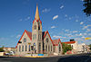 | Bernalillo | ||
| 397 | Southwestern Brewery and Ice Company |  | 601 Commercial St. NE, Albuquerque, New Mexico 35°5′20″N 106°38′44″W / 35.08889°N 106.64556°W / 35.08889; -106.64556 (Southwestern Brewery and Ice Company) | Bernalillo | Built in 1899, the Southwestern Brewery and Ice Company building is one of the few surviving 19th-century commercial buildings in downtown Albuquerque. |
| 424 | Ake Site | Catron | |||
| 453 | KiMo Theater |  | Bernalillo | ||
| 508 | Old Albuquerque High School |  | Bernalillo | ||
| 584 | Deming Armory |  | 301 South Silver Avenue 32°16′0.02″N 107°45′24.39″W / 32.2666722°N 107.7567750°W / 32.2666722; -107.7567750 (Deming Armory) | Deming | Built for the National Guard in 1915-16, it was the first armory to be built after New Mexico became a state in 1912, and was used during Pancho Villa's raid on Columbus |
| 588 | Rosenwald Building |  | Bernalillo | ||
| 660 | First National Bank Building |  | Bernalillo | ||
| 700 | Federal Building and United States Courthouse | 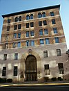 | Bernalillo | ||
| 737 | Harwood School |  | Bernalillo | ||
| 784 | Skinner Building | 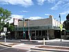 | Bernalillo | ||
| 787 | New Mexico-Arizona Wool Warehouse |  | Bernalillo | ||
| 802 | Taos Inn | 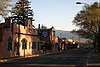 | Taos | ||
| 880 | Werner-Gilchrist House | 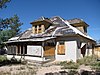 | Bernalillo | ||
| 991 | Nob Hill Business Center |  | Bernalillo | ||
| 992 | Old Hilton Hotel | 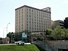 | Bernalillo | ||
| 1170 | Sunshine Building |  | 120 Central Avenue SW, Albuquerque, New Mexico 35°5′3″N 106°38′56″W / 35.08417°N 106.64889°W / 35.08417; -106.64889 (Sunshine Building) | Bernalillo | |
| 1171 | Solar Building | 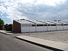 | Bernalillo | ||
| 1568 | Jones Motor Company | 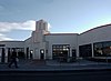 | Bernalillo | ||
| 1644 | Coronado School | Bernalillo | |||
| 1659 | Ernie Pyle House/Library |  | Bernalillo | ||
| 1837 | De Anza Motor Lodge | 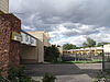 | Bernalillo | ||
| 1841 | D. H. Lawrence Ranch Historic District | 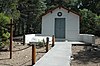 | Taos | ||
| 1853 | Southern Union Gas Company Building |  | Bernalillo |
See also
- List of National Historic Landmarks in New Mexico
- National Register of Historic Places listings in New Mexico
References
^ Registers of Cultural Properties, New Mexico Historic Preservation Division
^ "New Mexico State and National Registers". New Mexico Historic Preservation Commission. Retrieved 03-12-2013. Check date values in:|accessdate=(help).mw-parser-output cite.citation{font-style:inherit}.mw-parser-output q{quotes:"""""""'""'"}.mw-parser-output code.cs1-code{color:inherit;background:inherit;border:inherit;padding:inherit}.mw-parser-output .cs1-lock-free a{background:url("//upload.wikimedia.org/wikipedia/commons/thumb/6/65/Lock-green.svg/9px-Lock-green.svg.png")no-repeat;background-position:right .1em center}.mw-parser-output .cs1-lock-limited a,.mw-parser-output .cs1-lock-registration a{background:url("//upload.wikimedia.org/wikipedia/commons/thumb/d/d6/Lock-gray-alt-2.svg/9px-Lock-gray-alt-2.svg.png")no-repeat;background-position:right .1em center}.mw-parser-output .cs1-lock-subscription a{background:url("//upload.wikimedia.org/wikipedia/commons/thumb/a/aa/Lock-red-alt-2.svg/9px-Lock-red-alt-2.svg.png")no-repeat;background-position:right .1em center}.mw-parser-output .cs1-subscription,.mw-parser-output .cs1-registration{color:#555}.mw-parser-output .cs1-subscription span,.mw-parser-output .cs1-registration span{border-bottom:1px dotted;cursor:help}.mw-parser-output .cs1-hidden-error{display:none;font-size:100%}.mw-parser-output .cs1-visible-error{font-size:100%}.mw-parser-output .cs1-subscription,.mw-parser-output .cs1-registration,.mw-parser-output .cs1-format{font-size:95%}.mw-parser-output .cs1-kern-left,.mw-parser-output .cs1-kern-wl-left{padding-left:0.2em}.mw-parser-output .cs1-kern-right,.mw-parser-output .cs1-kern-wl-right{padding-right:0.2em}
^ Numbers are as designated in the New Mexico State Register 2012 Report: Section 3 Archived 2014-11-10 at the Wayback Machine..
External links
- Official website


