Bhubaneswar
Bhubaneswar Bhubaneswara Ekamra Khetra | |
|---|---|
Metropolis | |
     From Top; Left to Right: Udayagiri and Khandagiri Caves, Lingaraj Temple, Rajarani Temple, Nandankanan Zoological Park, and Dhauli Shanti Stupa | |
| Nicknames: Sports Capital of India Temple City of India IT Hub and Startup Hub of East India[1] | |
 Bhubaneswar Bhubaneswar, Odisha Show map of India  Bhubaneswar Bhubaneswar (Odisha) Show map of Odisha | |
| Coordinates: 20°16′N 85°50′E / 20.27°N 85.84°E / 20.27; 85.84Coordinates: 20°16′N 85°50′E / 20.27°N 85.84°E / 20.27; 85.84 | |
| Country | India |
| State | Odisha |
| District | Khordha |
| Named for | Lord Shiva's name: Bhubaneswar |
| Government | |
| • Type | Municipal Corporation |
| • Body | Bhubaneswar Municipal Corporation (BMC) |
| • Mayor | Anant Narayana Jena (BJD) |
| • Municipal Commissioner | Dr. Krishan Kumar, IAS |
| • Commissioner of Police | Satyajit Mohanty, IPS |
| Area | |
| • Metropolis | 422 km2 (163 sq mi) |
| Elevation | 58 m (190 ft) |
| Population (2011)[2] | |
| • Metropolis | 837,321 |
| • Rank | 60 |
| • Density | 2,131.37/km2 (5,520.2/sq mi) |
| • Metro | 881,988 |
| Demonym(s) | Bhubaneswarites [3] Bhubaneswaria[4] |
| Languages | |
| • Official | Odia, English |
| Time zone | UTC+5:30 (IST) |
| PIN | 751xxx |
| Telephone code | 0674 |
| Vehicle registration | OD-02 (Acharya Vihar) OD-33 (Patia) |
| UN/LOCODE | IN BBI |
| Website | www.bhubaneswar.me |
Bhubaneswar /ˌbhubɔːnəsuɔːrɔː/ (![]() listen) is the capital of the Indian state of Odisha. It is the largest city in Odisha and is a centre of economic and cultural importance in Eastern India.
listen) is the capital of the Indian state of Odisha. It is the largest city in Odisha and is a centre of economic and cultural importance in Eastern India.
Along with the old town, the region historically was often depicted as Ekamra Khetra (Temple City). With the diverse ranges of heritage resources, it showcases significant sacred cultural landscape components which have evolved with the support of available natural resource base and cultural trigger.[5]
Although the modern city of Bhubaneswar was formally established only in 1948, the history of the areas in and around the present-day city can be traced to the 3rd century BCE and earlier. It is a confluence of Hindu, Buddhist and Jain heritage boasting of some of the finest Kalingan temples. With many 6th-13th century CE Hindu temples, which span the entire spectrum of Kalinga architecture, Bhubaneswar is often referred to as a "Temple City of India". With Puri and Konark it forms the Swarna Tribhuja ("Golden Triangle"), one of eastern India's most visited destinations.[6]
Bhubaneswar replaced Cuttack as the capital on 19 August 1949, 2 years after India gained its independence from Britain. The modern city was designed by the German architect Otto Königsberger in 1946. Along with Jamshedpur and Chandigarh, it was one of modern India's first planned cities. Bhubaneswar and Cuttack are often referred to as the 'twin cities of Odisha'. The metropolitan area formed by the two cities had a population of 1.7 million in 2011.[7] Bhubaneswar is categorised as a Tier-2 city. An emerging information technology (IT) and education hub, Bhubaneswar is one of the country's fastest-developing cities.
Contents
1 Etymology
2 History
3 Geography
3.1 Urban structure
3.2 Climate
4 Economy
5 Demographics
5.1 Population
5.2 Literacy
5.3 Language
6 Civic administration and utilities
6.1 Utilities
7 Education
7.1 Primary & secondary education
7.2 Higher Education
7.2.1 Engineering and Applied Sciences Institutions
7.2.2 Medical Institutions
7.2.3 Universities
8 Transport
8.1 Road
8.2 Rail
8.3 Air
9 Culture
9.1 Odissi dance
9.2 Dressing and Attire
9.3 Festivals
9.4 Cuisine
10 Sports
11 Media
12 Notable people
13 Sister cities
14 See also
15 References
16 External links
Etymology
'Bhubaneswar(ଭୁବନେଶ୍ୱର)', derived its name from Tribhubaneswar (ତ୍ରିଭୁବନେଶ୍ୱର), which literally means the Lord (Eeswar) of the Three World (Tribhuban), which refers to Shiva.[8]
History

Remains of the ancient city of Sisupalgarh, on the outskirts of Bhubaneswar, dated between 3rd century BCE

Hathigumpha inscriptions at the Udayagiri and Khandagiri caves near Bhubaneswar
The foundation of the modern Bhubaneswar city was laid in 1948, although the areas in and around the city have a history going back to 1st century BCE or earlier.[9]
Dhauli, near Bhubaneswar was the site of the Kalinga War (c. 262-261 BCE), in which the Mauryan emperor Ashoka invaded and annexed Kalinga.[9] One of the most complete edicts of the Mauryan Emperor, Ashoka, dating from between 272–236 BCE, remains carved in rock 8 kilometres (5.0 mi) to the southwest of the modern city.[10] After the decline of the Mauryan empire, the area came under the rule of Mahameghavahana dynasty, whose most well-known rule is Kharavela. His Hathigumpha inscription is located at the Udayagiri and Khandagiri Caves near Bhubaneswar. The area was subsequently ruled by several dynasties, including Satavahanas, Guptas, Matharas, and Shailodbhavas.[9]
In 7th century, Somavamshi or Keshari dynasty established their kingdom in the area, and constructed a number of temples. After the Kesharis, the Eastern Gangas ruled Kalinga area until 14th century CE. Their capital Kalinganagar was located in present-day Bhubaneswar district. After them, Mukunda Deva of the Bhoi dynasty – the last Hindu ruler of the area until the Marathas – developed several religious buildings in the area.[9] Most of the older temples in Bhubaneswar were built between 8th and 12th centuries, under Shaiva influence. The Ananta Vasudeva Temple is the only old temple of Vishnu in the city.[11] In 1568, the Karrani dynasty of Afghan origin gained control of the area. During their reign, most of the temples and other structures were destroyed or disfigured.[9]
In the 16th century, the area came under pachamani Mughal control. The Marathas, who succeeded the Mughals in mid-18th century, encouraged pilgrimage in the region. In 1803, the area came under British colonial rule, and was part of the Bengal Presidency (until 1912), Bihar and Orissa Province (1912-1936) and Orissa Province (1936-1947).[9] The capital of the British-ruled Orissa Province was Cuttack, which was vulnerabile to floods and suffered from space constraints. Because of this, on 30 September 1946, a proposal to move the capital to a new capital was introduced in the Legislative Assembly of the Orissa Province. After independence of India, the foundation of the new capital was laid by Prime Minister Jawaharlal Nehru on 13 April 1948.[9]
The name of the new capital came from "Tribhubaneswar" or "Bhubaneswar" (literally "Lord of the Earth"), a name of Shiva, the deity of the Lingaraja temple.[8] The Legislative Assembly of Orissa was shifted from Cuttack to Bhubaneswar in 1949.[9] Bhubaneswar was built as a modern city, designed by German architect Otto Königsberger with wide roads, gardens and parks.[12] Though part of the city followed the plan, it grew rapidly over the next few decades, outstripping the planning process.[13] According to the first census of independent India, taken in 1951, the city's population was just 16,512. From 1952 to 1979, it was administered by a Notified Area Council or a nagar panchayat; a municipality was established only on 12 March 1979. By the 1991 census, the population of Bhubaneswar had increased to 411,542. Accordingly, on 14 August 1994, the Bhubaneswar Municipal Corporation was established.[9]
Geography
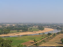
Daya River at the foothills of Dhauli
Bhubaneswar is in Khordha district of Odisha.[14] It is in the eastern coastal plains, along the axis of the Eastern Ghats mountains.[15] The city has an average altitude of 45 m (148 ft) above sea level.[15] It lies southwest of the Mahanadi River that forms the northern boundary of Bhubaneswar metropolitan area, within its delta.

City of Bhubaneswar from Khandagiri hill
The city is bounded by the Daya River to the south and the Kuakhai River to the east;[15] the Chandaka Wildlife Sanctuary and Nandankanan Zoo lie in the western and northern parts of Bhubaneswar, respectively.[12]
Bhubaneswar is topographically divided into western uplands and eastern lowlands, with hillocks in the western and northern parts.[15]Kanjia lake on the northern outskirts, affords rich biodiversity and is a wetland of national importance.[16] Bhubaneswar's soils are 65 per cent laterite, 25 per cent alluvial and 10 per cent sandstone.[17] The Bureau of Indian Standards places the city inside seismic zone III on a scale ranging from I to V in order of increasing susceptibility to earthquakes.[18] The United Nations Development Programme reports that there is "very high damage risk" from winds and cyclones.[18] The 1999 Odisha cyclone caused major damage to buildings, the city's infrastructure and cost many human lives.[19][20] Floods and waterlogging in the low-lying areas have become common due to unplanned growth.[17][21]

Bhubaneswar Schematic Tourist Map
Urban structure

Rajpath, Bhubaneswar

Pathani Samanta Planetarium Bhubaneswar
The Bhubaneswar urban development area consists of the Bhubaneswar Municipal Corporation area, 173 revenue villages and two other municipalities spread over 393.57 square kilometres (151.96 sq mi).[22] The area under the jurisdiction of the Bhubaneswar Municipal Corporation covers 186 square kilometres (72 sq mi).[23] The city is somewhat dumbbell-shaped with most of the growth taking place to the north, northeast and southwest.[24] The north–south axis of the city is widest, at roughly 22.5 kilometres (14.0 mi). Growth in the east is restricted due to the presence of Kuakhai River and by the wildlife sanctuary in the northwestern part.[24] The city can be broadly divided into the old town, planned city (or state capital), added areas and outer peripheral areas. It is subdivided into Units and Colonies.
The old town or "Temple Town", the oldest part of the city, is characterised by many temples, including the Lingaraj, Rajarani, and Muktesvara temples, standing alongside residential areas. This area is congested, with narrow roads and poor infrastructure.[24] Among neighbourhoods in the old town are Rajarani Colony, Pandav Nagar, Brahmeswar Bagh, Lingaraj Nagar, Gouri Nagar, Bhimatanki and Kapileswar.
The planned city was designed in 1948 to house the capital. It is subdivided into units, each with a high school, shopping centres, dispensaries and play areas. While most of the units house government employees, Unit V houses the administrative buildings, including the State Secretariat, State Assembly, and the Raj Bhavan. Private residential areas were later built in other areas of the planned city, including Saheed Nagar and Satya Nagar. Unit I, popularly known as the Market Building, was formed to cater to the shopping needs of the new capital's residents. Later, markets and commercial establishments developed along the Janpath and Cuttack-Puri Road at Saheed Nagar, Satya Nagar, Bapuji Nagar and Ashok Nagar. A dedicated institutional area houses educational and research institutes, including Utkal University, the Institute of Physics, the Institute of Minerals and Materials Technology and Sainik School. Indira Gandhi Park, Gandhi Park and the Biju Patnaik Park are located in the unit.[24]
The added areas are mostly areas lying north of National Highway 5, including Nayapalli, Jayadev Vihar, Chandrasekharpur and Sailashree Vihar, which were developed by Bhubaneswar Development Authority to house the growing population.[24]
The peripheral areas are outside the municipal boundary or have subsequently been included within the extended boundary, including Tomando, Patia and Raghunathpur. Most of these areas were developed in a haphazard manner, without proper planning.[25]

Bhubaneswar secured the top rank in the Smart city list in India.[26]
Climate

Meteorological Centre, Bhubaneswar
Bhubaneswar has a tropical savanna climate, designated Aw under the Köppen climate classification. The annual mean temperature is 27.4 °C (81.3 °F); monthly mean temperatures are 22–32 °C (72–90 °F).[27] Summers (March to June) are hot and humid, with temperatures in the low 30s C; during dry spells, maximum temperatures often exceed 40 °C (104 °F) in May and June.[27] Winter lasts for only about ten weeks, with seasonal lows dipping to 15–18 °C (59–64 °F) in December and January. May is the hottest month, when daily temperatures range from 32–42 °C (90–108 °F). January, the coldest month, has temperatures varying from 15–28 °C (59–82 °F). The highest recorded temperature is 45 °C (113.0 °F), and the lowest is 8.2 °C (47 °F).[27]
Rains brought by the Bay of Bengal branch of the south west summer monsoon[28] lash Bhubaneswar between June and September, supplying it with most of its annual rainfall of 1,542 mm (61 in). The highest monthly rainfall total, 330 mm (13 in), occurs in August.[27]
| Climate data for Bhubaneswar | |||||||||||||
|---|---|---|---|---|---|---|---|---|---|---|---|---|---|
| Month | Jan | Feb | Mar | Apr | May | Jun | Jul | Aug | Sep | Oct | Nov | Dec | Year |
| Record high °C (°F) | 35.8 (96.4) | 42.7 (108.9) | 42.0 (107.6) | 45.0 (113) | 46.5 (115.7) | 46.3 (115.3) | 41.3 (106.3) | 37.4 (99.3) | 37.9 (100.2) | 36.6 (97.9) | 37.6 (99.7) | 33.6 (92.5) | 46.5 (115.7) |
| Average high °C (°F) | 28.7 (83.7) | 31.4 (88.5) | 34.9 (94.8) | 36.9 (98.4) | 37.2 (99) | 35.3 (95.5) | 32.2 (90) | 31.6 (88.9) | 32.1 (89.8) | 32.2 (90) | 30.4 (86.7) | 28.4 (83.1) | 32.6 (90.7) |
| Daily mean °C (°F) | 22.2 (72) | 25.1 (77.2) | 28.6 (83.5) | 30.9 (87.6) | 31.7 (89.1) | 30.7 (87.3) | 28.7 (83.7) | 28.4 (83.1) | 28.5 (83.3) | 27.6 (81.7) | 24.9 (76.8) | 22.0 (71.6) | 27.4 (81.3) |
| Average low °C (°F) | 15.6 (60.1) | 18.7 (65.7) | 22.2 (72) | 25.0 (77) | 26.2 (79.2) | 26.1 (79) | 25.2 (77.4) | 25.1 (77.2) | 24.8 (76.6) | 23.0 (73.4) | 19.4 (66.9) | 15.6 (60.1) | 22.2 (72) |
| Record low °C (°F) | 8.6 (47.5) | 9.6 (49.3) | 14.6 (58.3) | 17.0 (62.6) | 15.0 (59) | 16.8 (62.2) | 20.0 (68) | 18.4 (65.1) | 18.5 (65.3) | 16.1 (61) | 9.7 (49.5) | 9.1 (48.4) | 8.6 (47.5) |
| Average precipitation mm (inches) | 4 (0.2) | 27 (1.1) | 28 (1.1) | 26 (1) | 67 (2.6) | 209 (8.2) | 317 (12.5) | 389 (15.3) | 241 (9.5) | 127 (5) | 48 (1.9) | 9 (0.4) | 1,492 (58.8) |
| Average rainy days | 0.4 | 2.3 | 2.8 | 3.1 | 5.1 | 12.0 | 18.0 | 19.1 | 14.6 | 8.8 | 2.1 | 0.7 | 89 |
| Average relative humidity (%) | 60 | 61 | 63 | 66 | 66 | 74 | 83 | 85 | 83 | 76 | 66 | 60 | 70 |
| Mean monthly sunshine hours | 253.4 | 234.0 | 237.8 | 238.8 | 242.9 | 140.7 | 107.2 | 128.6 | 150.8 | 221.8 | 217.5 | 255.0 | 2,428.5 |
| Source #1: NOAA (1971–1990)[29] | |||||||||||||
| Source #2: IMD[30] | |||||||||||||
Economy
Bhubaneswar is an administrative, information technology, education and tourism city .[15] Bhubaneswar was ranked as the best place to do business in India by the World Bank in 2014.[31] Bhubaneswar has emerged as one of the fast-growing, important trading and commercial hub in the state and eastern India. Tourism is a major industry, attracting about 1.5 million tourists in 2011.[15][32] Bhubaneswar was designed to be a largely residential city with outlying industrial areas. The economy had few major players until the 1990s and was dominated by retail and small-scale manufacturing. With the economic liberalisation policy adopted by the Government of India in the 1990s, Bhubaneswar received investment in telecommunications, information technology (IT) and higher education.[15]
As of 2001, around 2.15% of the city's workforce was employed in the primary sector (agriculture, forestry, mining, etc.); 2.18% worked in the secondary sector (industrial and manufacturing); and 95.67% worked in the tertiary sector (service industries).[15]
In 2011, according to a study by Associated Chambers of Commerce and Industry of India, Bhubaneswar had the highest rate of employment growth among 17 Tier-2 cities in India.[33] It has been listed among the top ten emerging cities in India by Cushman and Wakefield, taking into consideration factors like demographics, physical, social and real estate infrastructure, current level and scope of economic activities and government support.[34] In 2012, Bhubaneswar was ranked third among Indian cities, in starting and operating a business by the World Bank.[35]
Bhubaneswar has been traditionally home to handicrafts industry, including silver filigree work, appliqué work, stone and wood carvings and patta painting, which significantly contributes to the city's economy.[15] The late 2000s saw a surge of investments in the real estate, infrastructure, retail and hospitality sectors; several shopping malls and organised retails opened outlets in Bhubaneswar.[36][37][38][39]
The Department of Industries established four industrial areas in and around Bhubaneswar, in the Rasulgarh, Mancheswar, Chandaka, and Bhagabanpur areas.[15] In the informal sector, 22,000 vendors operate in regulated or unregulated vending zones.[40][41]
In 2009, Odisha was ranked ninth among Indian states in terms of software export by NASSCOM, with most IT/ITES companies established in Bhubaneswar.[42] In 2011–12, Odisha had a growth rate of 17% for software exports.[43] According to a 2012 survey, among the tier-2 cities in India, Bhubaneswar has been chosen as the best for conducting IT/ITES business.[44] The government fostered growth by developing of IT parks such as Infocity-1, Infovalley, STPI-Bhubaneswar and JSS STP.[45][46] Infocity was conceived as a five-star park, under the Export Promotion Industrial Parks (EPIP) Scheme to create infrastructure facilities for setting up information technology related industries. Infosys and Tech Mahindra have been present in Bhubaneswar since 1996. Other software companies include TCS, Wipro, IBM, Genpact, Firstsource, Mindtree, MphasiS, Ericsson, Semtech and Reliance Communications. Apart from the big multinationals, some 300 small and mid-size IT companies and business start ups have offices in Bhubaneswar.[46]
Demographics
Population
| Bhubaneswar population | |||
|---|---|---|---|
| Census | Pop. | %± | |
| 1951 | 16,512 | — | |
| 1961 | 38,211 | 131.4% | |
| 1971 | 105,491 | 176.1% | |
| 1981 | 227,525 | 115.7% | |
| 1991 | 423,465 | 86.1% | |
| 2001 | 647,302 | 52.9% | |
| 2011 | 837,737 | 29.4% | |
| Sources:[47][48][49] | |||
As per the 2011 census of India, Bhubaneswar had a population of 837,737, while the metropolitan area had a population of 881,988.[2][50] As per the estimate of IIT Kharagpur, which made a development plan, the Bhubaneswar-Cuttack Urban complex, consisting of 721.9 square kilometres (278.7 sq mi), has a population of 1.9 million (as of 2008[update]).[51] As of 2011[update], the number of males was 445,233, while the number of females were 392,504. The decadal growth rate was 45.90 per cent.[citation needed]
Literacy
Effective male literacy was 95.69 per cent, while female literacy was 90.26 per cent. About 75,237 were under six. Bhubaneswar's literacy rate is 93.15 per cent[2]—significantly higher than the national average of 74.04 per cent.[52]
Language
The main language spoken in the city is Odia, however, English and Hindi are understood by most residents. Although Odias comprise the vast majority, migrants from other states like Andhra Pradesh, Bihar, West Bengal and Jharkhand also dwell in city. Growth in the information technology industry and education sector in Bhubaneswar changed the city's demographic profile; likely infrastructure strains and haphazard growth from demographic changes have been a cause of concern.

Civic administration and utilities
The Bhubaneswar Municipal Corporation (BMC) oversees and manages civic infrastructure for the city's 67 wards.[53] Residents of each ward elect a corporator to the BMC for a five-year term. Standing committees handle urban planning and maintain roads, government-aided schools, hospitals and municipal markets.[54] As Bhubaneswar's apex body, the corporation discharges its functions through the mayor-in-council, which comprises a mayor, a deputy mayor and other elected members. The executive wing is headed by a Commissioner. BMC responsibilities include drainage and sewerage, sanitation, solid waste management and street lighting.[15] As of 2014[update], the Biju Janata Dal party controlled the BMC; the mayor was Ananta Narayan Jena and deputy mayor was K. Shanti.[55] The Bhubaneswar Development Authority is responsible for statutory planning and development and building regulation.[15]
As the seat of the Government of Odisha, Bhubaneswar is home to the Odisha Legislative Assembly and the state secretariat. Bhubaneswar has lower courts: the Court of Small Causes and the District Civil Court decide civil matters; the Sessions Court rules in criminal cases.[56] The Bhubaneswar–Cuttack Police Commissionerate, established in 2008, is a city police force with primary responsibilities in law enforcement and investigation in the Bhubaneswar-Cuttack area.[57][58] Shri Yogesh Bahadur Khurania is the police commissioner.[59]
Citizens of Bhubaneswar elect one representative to India's lower house, the Lok Sabha, and three representatives to the state legislative assembly, through the constituencies of Bhubaneswar North, Ekamra-Bhubaneswar and Bhubaneswar Central.[60][61]

Odisha State Secretariat building
Utilities
Electricity is supplied by the state-operated Central Electricity Supply Utility of Odisha, or CESU.[17] Fire services are handled by the state agency Odisha Fire Service. Drinking water is sourced from the Mahanadi, Kuakhai and Daya rivers. Water supply and sewerage are handled by the Public Health Engineering Organisation.[15] State-owned Bharat Sanchar Nigam Limited, or BSNL, as well as private enterprises, among them Vodafone, Bharti Airtel, Reliance, Idea Cellular, Aircel, and Tata DoCoMo, are the leading telephone, cell phone and internet service providers in the city.[62][63]
Education

Academic Block of Xavier Institute of Management, Bhubaneswar

Institute Of Physics Bhubaneswar library
Bhubaneswar is a centre for higher education in the Eastern Region with several government and privately funded Universities and colleges.
Primary & secondary education
Odia and English are the primary languages of instruction. Schools in Bhubaneswar follow the "10+2+3" plan for Regular Graduates and "10+2+4" plan for Technical studies. Schools in Bhubaneswar are either run by the state government or private organisations. Students typically enroll in schools that are affiliated with any of the following mediums of Education.
- BSE, Odisha
- CHSE, Odisha
- CBSE
- Council for the Indian School Certificate Examinations
- SCTE&VT, Odisha
Notable private schools in the city include D.A.V. Public School, Chandrasekharpur, and DAV Public School, Unit-8.
Government schools located in Bhubaneswar include Kendriya Vidyalaya No.1, Sainik School, Badagada Government High School and Capital High School.
Higher Education
Several Colleges are affiliated with Universities or institution based in Bhubaneswar or elsewhere in India. Most offer a wide range of programs in STEM & Applied Research and are rated highly by the Ministry of Human Resource Development, India
Engineering and Applied Sciences Institutions
- Central Institute of Freshwater Aquaculture
- Indian Institute of Technology Bhubaneswar
Institute of Chemical Technology, Mumbai (Off Campus in collaboration with IndianOil and IIT Kharagpur)- Institute of Life Sciences
Institute of Minerals and Materials Technology (IMMT, erstwhile RRL)- Institute of Physics
International Institute of Information Technology, Bhubaneswar (IIIT-BH)
National Institute of Fashion Technology (NIFT)
National Institute of Science Education and Research (NISER)- Regional Institute of Education
Medical Institutions
- All India Institute of Medical Sciences Bhubaneswar
- Hi-Tech Medical College & Hospital, Bhubaneswar
- Institute of Medical Sciences and Sum Hospital
- Kalinga Institute of Medical Sciences
- Regional Medical Research Center
Universities
- Kalinga Institute of Industrial Technology
- Orissa University of Agriculture and Technology
- Rama Devi Women's University
- Siksha 'O' Anusandhan
- Utkal University
- Utkal University of Culture
- Xavier University
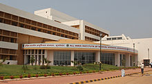
All India Institute of Medical Sciences Bhubaneswar
Tourism education is another field of study emerging. The Eastern Regional Centre of Indian Institute of Tourism and Travel Management (IITTM), the second in the country after Gwalior, was established in 1996. One IATA Authorised Training Centre (ATC) is also located in the city premises. Several regional management educational institutions also have travel and tourism related courses in their curriculum.
Transport
The headquarters of the Odisha State Road Transport Corporation (OSRTC) is in Bhubaneswar. The main Bhubaneswar inter-state bus terminus is at Barmunda, 8 kilometres (5.0 mi) from the city centre, from where OSRTC and private operators run buses connecting Bhubaneswar to cities in Odisha and with the neighbouring states of Andhra Pradesh, Jharkhand, West Bengal and Chhattisgarh.[64] Bhubaneswar is connected to the rest of Odisha and India by National Highway-NH 16, which is a part of the Kolkata-Chennai prong of the Golden Quadrilateral, NH 203, State Highway 13 (Odisha) and State Highway 27 (Odisha). Asian Highway- AH 45 passes through the city.[22] Nowadays popular online cab or auto transport system provided by Jugnoo, Ola, uber are widely used.
Road

Aerial view of a flyover, Bhubaneswar.
Bhubaneswar has roads in grid form in the central city. Bhubaneswar has approximately 1,600 kilometres (990 mi) of roads, with average road density of 11.82 square kilometres (4.56 sq mi).[15] Baramunda Inter State Bus Terminus (ISBT) is the major bus terminus in the city from where buses ply to all the districts in Odisha as well as to neighbouring state's cities like Hyderabad, Kolkata, Visakhapatnam, Raipur and Ranchi. City bus service (Mo Bus) runs across Bhubaneswar by Capital Region Urban Transport Authority runed by Bhubaneswar Development Authority .[65] A fleet of 300+ buses cover all major destinations including Cuttack, Puri and Khordha.[65]Auto rickshaws are available for hire and on a share basis throughout the city.[66][67] In parts of the city, cycle rickshaws offer short trips.[68] Also CRUT recently has launched Mo Cycle , a public bicycle Sharing platform to curb traffic, reducing pollution in city and providing last mile connectivity in city. To ease traffic jams, over-bridges at major road junctions and expansion of roads are under construction.[69][70] In a study of six cities in India, Bhubaneswar was ranked third concerning pedestrian infrastructure. The city scored 50 points out of maximum 100.
Rail

Bhubaneswar railway station

East Coast Railway Headquarters in Bhubaneswar
Bhubaneswar has the following stations :
| Station Name | Station Code | Railway Zone | Number of Platforms |
|---|---|---|---|
Bhubaneswar | BBS | East Coast Railway | 6 |
Mancheswar | MCS | East Coast Railway | 4 |
Lingaraj Temple Road | LGTR | East Coast Railway | 3 |
Vani Vihar | BNBH | East Coast Railway | 2 |
Patia | PTAB | East Coast Railway | 2 |
New Bhubaneswar | BBSN | East Coast Railway | 7 |
The East Coast Railway has its headquarters in Bhubaneswar. Bhubaneswar railway station is one of the main stations of the Indian railway network. It is connected to major cities by daily express and passenger trains and daily service to all metro cities is available from here. However, the station is overloaded by existing traffic. Currently, the station has six platforms. There are plans to add two more platforms.[71]
A satellite station New Bhubaneswar railway station is opened near Barang in July 2018 to decongest the existing installation.[72]
Currently, there are also plans for a metro system of 30 km, which will serve the twin cities of Bhubaneswar and Cuttack.
Air
Biju Patnaik International Airport (IATA: BBI, ICAO: VEBS), also known as Bhubaneswar Airport, 3 kilometres (1.9 mi) south of the city centre, is the major and sole international airport in Odisha. There are daily domestic flights from Bhubaneswar to Delhi, Hyderabad, Mumbai, Kolkata, Vishakhapatnam, Chennai and Bangalore. There are international flights from Bhubaneswar to Bangkok, Kualalumpur and Dubai thrice a week. The major carriers from Bhubaneswar are Indigo, Vistara, GoAir, AirAsia, AirAsia India and Air India. In March 2013, a new domestic terminal with a capacity of handling 30 million passengers per year was inaugurated to handle increased air traffic.[73] On 10 July 2015, the first international flight took off from terminal 2 of Biju Patnaik International Airport.
Culture

Muktesvara deula, covered with erotic ancient carvings, known for its quality of sculptures

Bindusagar water tank
Ravindra Mandap, an auditorium in Bhubaneswar
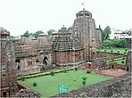
Bhubaneswar is supposed to have had over one thousand temples, earning the tag of the 'Temple City of India'. Temples are made in the Kalinga architectural style with a pine spire that curves up to a point over the sanctum housing the presiding deity and a pyramid-covered hall where people sit and pray.
Famous temples include Lingaraj Temple, Muktesvara Temple, Rajarani Temple, Ananta Vasudeva Temple.[74]
The twin hills of Khandagiri & Udayagiri, served as the site of an ancient Jain monastery which was carved into cave-like chambers in the face of the hill. These caves, with artistic carvings, date back to the 2nd century BCE. Dhauli hills has major edicts of Ashoka engraved on a mass of rock and a white Peace Pagoda was built by the Japan Buddha Sangha and the Kalinga Nippon Buddha Sangha in the 1970s. Apart from the ancient temples, other important temples were built in recent times include Ram Mandir and ISKCON.
Bhubaneswar along with Cuttack is the home of the Oriya cinema industry, dubbed "Ollywood", where most of the state's film studios are situated.
Odia culture survives in the form of Classical Odissi dance, handicrafts, sand artistry and sculpturing as well as theatre and music. Boundary walls and gardens are increasingly being redone to depict the folk art of the state.[75][76]Odissi, the oldest of the eight surviving classical dance forms of India can be traced from archaeological evidence from the temples in Bhubaneswar.[77][78][79]
Odissi dance
Odissi dance is generally accompanied by Odissi music. Srjan, the Odissi dance academy founded by Guru Kelucharan Mohapatra, the legendary Odissi dancer is found here.[80][81] The Rabindra Mandap in central Bhubaneswar plays host to cultural engagements, theatre and private functions.[82]

Dhauli Giri Shanti Stupa
Dressing and Attire
Though Odia women traditionally wear the sari and the shalwar kameez, Western attire is gaining acceptance among younger women.[83] Western-style dress has greater acceptance among men, although the traditional dhoti and kurta are seen during festivals.[84]
The Odisha State Museum offers archaeological artefacts, weapons, local arts and crafts as well as insights into Odisha's natural and indigenous history.[85] The Tribal Research Institute Museum hosts authentic tribal dwellings created by tribal craftsmen.[86]Nandankanan Zoological Park, located on the northern outskirt of the city, is India's first zoo to join World Association of Zoos and Aquariums.[87][88] The State Botanical Garden (Odisha) and Regional Plant Resource Center, popularly known as Ekamra Kanan, a park and botanical garden, has a large collection of exotic and regional fauna. The Ekamra Haat is a hand-loom and handicrafts market. Nicco Park and Ocean World are amusement parks. Other museums include Pathani Samanta Planetarium, Regional Museum of Natural History, Regional Science Center and State Handicrafts Museum.
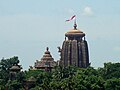
Lingaraj Temple

Sideshvara temple


Festivals
On the day of Ashokashtami in the month of March or April, the image of Lingaraja (Shiva) and other deities are taken in a procession from Lingaraja Temple to the Mausima Temple, where the deities remain for four days.[89] Hundreds of devotees participate in pulling the temple car that carries the deities, known as Rukuna Rath.[90]Ratha-Yatra, "Temple Car Festival," is the most important festival in Odisha and Bhubaneswar.[91] The festival commemorates Jagannath, who is said to have been the incarnation of India's revered deities, Vishnu and Krishna. Durga Puja, held in September–October, is an occasion for glamorous celebrations.[92][93]
As a part of the Ekamra Festival, many cultural sub-festivals takes place in January in Bhubaneswar which includes Kalinga Mahotsav (for traditional martial arts), Dhauli-Kalinga Mahotsav (for classical dance forms), Rajarani Music Festival (for classical music) and Mukteswar Dance Festival (for Odishi dance).[94] Residents engage in khattis, or leisurely chats, that often take the form of freestyle intellectual conversation.[95]
Other festivals celebrated include Shivaratri, Diwali, Ganesh Puja, Nuakhai and Saraswati Puja. Eid and Christmas are celebrated by the religious minorities in the city.[96][97][98]
Adivasi Mela is a fair that displays art, artefacts, tradition, culture, and music of the tribal inhabitants of Odisha is held in January.[99] Toshali National Crafts Mela, held in December, showcases handicrafts from all over India and from foreign countries.[100] Other important fairs in the city include the Rajdhani Book Fair and Khandagiri Utsav.[101][102]
In modern times Bhubaneswar hosts a literary festival the "Odisha Literary Fest".[103]
Cuisine

Pahala Rasagola, famous sweet originated in Odisha

Chhena Gaja, one more famous sweet of Odisha
Key elements of the city's cuisine include rice and a fish curry known as Machha Jhola, which can be accompanied by desserts such as Rasagola, Rasabali, Chhena Gaja, Chhena Jhilli and Chhena Poda.[104] Odisha's large repertoire of seafood dishes includes various preparations of lobsters and crabs brought in from Chilika Lake.[105]
Street foods such as Gupchup (a deep-fried crêpe, stuffed with a mix of mashed potatoes and boiled yellow peas, and dipped in tamarind-infused water), Cuttack-chaat, Dahi bara-Aloo dum (a deep-fried doughnut-shaped lentil dumpling marinated in yogurt-infused water, and served alongside potato curry) and Bara-ghuguni are sold all over the city.[106] Traditional Oriya food such as Dahi-Pakhal (rice soaked in water with yogurt and seasonings) which is considered as a body coolant, accompanied by Badi chura or saga are consumed during months of April–June.[107]
The Abadha of Lingaraj Temple and Ananta Vasudeva Temple served for devotees is considered a vegetarian culinary delight. Other vegetarian dishes are Dalma (made of lentils and vegetables boiled together and then fried with other spices) and Santula (lightly spiced steamed vegetables).[105] Sweets play a large part in the diet of Bhubaneswarites—especially at their social ceremonies. Bhubaneswar is known for its kora-khhaii which are made up of paddy, jaggery and coconut pieces. Pitha, a kind of sweet cake, bread or dim sum are winter specialties.[citation needed]
Sports

Kalinga Stadium, Bhubaneswar

Bhubaneswar Golf Club
Bhubaneswar's major sporting arena is the Kalinga Stadium, having facilities for athletics, football, hockey, basketball, tennis, table tennis and swimming.[108][109][110]. It is known for hosting the Odisha Hockey World Cup in November-December 2018. Kalinga Lancers, the sixth franchise of Hockey India League and Samaleswari S.C., a franchise of I-League 2nd Division, are based in Bhubaneswar with Kalinga Stadium as their home ground. East Coast Railway Stadium, a prominent cricket stadium hosts Ranji Trophy and other matches.[111]
Construction of gallery and stadium renovation is in process. An air-conditioned indoor stadium with a capacity of 2000 spectators for badminton, volleyball, basketball and table tennis games is under construction.[108]Barabati Stadium in Cuttack, Odisha's only venue for international cricket matches, is located around 25 kilometres (16 mi) away.[112] Bhubaneswar has a franchise of Odisha Premier League, Bhubaneswar Jaguars, which started in 2010. Bhubaneswar Golf Club, a nine-hole golf course is situated in Infocity.[113]
Kalinga Institute of Industrial Technology Stadium commonly KIIT Stadium is a new multipurpose stadium located as a part of Kalinga Institute of Industrial Technology University Campus or KIIT University in Bhubaneswar with a capacity of 40,000 currently.
The 2017 Asian Athletics Championships was the 22nd edition of the Asian Athletics Championships. It was held from 6 to 9 July 2017 at the Kalinga Stadium. Bhubaneswar is the third Indian-city to host the Asian Athletics Championship with Delhi in 1989 being the first and Pune in the year 2013 to be the second Indian cities.[114]
Bhubaneswar is emerging as the new sports capital of India, like FIH and
IOA president Narindar Batra recently said in an ceremony while unveiling the new logo for Indian hockey team Jersey, which is sponsored by the government of odisha, as it is giving equal importance and opportunity for all types of sports like cricket, football, field hockey, tennis, badminton, chess and many more.[115]
Media
The city's widely circulated Odia-language newspapers are Sambad, Dharitri, Pragatibadi, Samaja, Khabar, Orissa Bhaskara, Prameya and Samaya.[116]Odia Post and Odia Age are the English-language newspaper that is produced and published from Bhubaneswar. Other popular English-language newspapers published and sold in Bhubaneswar include The Times of India, The Telegraph, The Statesman, Hindustan Times, The Hindu, The Indian Express, and the Asian Age.[116] Bhubaneswar has substantial circulation of financial dailies, including The Economic Times, The Financial Express, Business Line, and Business Standard.[116] Vernacular newspapers, such as those in the Hindi, Bengali and Telugu, are read by minorities.[116] Major periodicals based in Bhubaneswar include Saptahik Samaya, Saptahik Samaja, and Kadambini.
All India Radio, the national state-owned radio broadcaster, airs several AM channels from the radio station located in Cuttack.[117] Bhubaneswar has five local radio stations broadcasting on FM, including two from AIR.[117][118] India's state-owned television broadcaster Doordarshan Odia provides two free-to-air terrestrial channels,[119] while a mix of Oriya, Hindi, English, and other regional channels are accessible via cable subscription and direct-broadcast satellite services. Some of the Odia language television channels are Colors Odia, Sarthak TV and Tarang TV. Oriya-language 24-hour television news channels include News 7, Odisha TV, Kanak TV, ETV News Odia, MBC TV and Naxatra News.[120]
Notable people
The following are some of the notable people associated with Bhubaneswar:[clarification needed]
- Subroto Bagchi
- Ranjib Biswal
- Nabakrushna Choudhuri
- Bud Mishra
- Akshaya Mohanty
- Aparajita Mohanty
- Bijay Mohanty
- Chandra Talpade Mohanty
- Debashish Mohanty
- Uttam Mohanty
- Saraju Mohanty
- Bibhu Mohapatra
- Kelucharan Mohapatra
- Sona Mohapatra
- Mira Duttaray
- Sanjukta Panigrahi
- Ramesh Chandra Parida
- Prasanna Kumar Patasani
- Naveen Patnaik
- Janaki Ballabh Patnaik
- Bijayananda Patnaik
- Sudarshan Patnaik
- Rakesh Pradhan
- Trilochan Pradhan
- Mahasweta Ray
- Tandra Ray
- Archita Sahu
- Salabega
- Pathani Samant
- Achyuta Samanta
- Nandini Satpathy
- Mayadhar Swain
Sister cities
 Cupertino, California, United States (16 August 2011).[121][122]
See also
- Bhubaneswar ITIR
- List of neighbourhoods in Bhubaneswar
- List of parks in Bhubaneswar
- List of temples in Bhubaneswar
- List of twin towns and sister cities in India
- Sahadevesvara Siva Temple
- Nandankanan Zoological Park
References
^ http://www.thestartupjournal.com/bhubaneswar-startup-hub/
^ abc "Cities having population 1 lakh and above" (PDF). Census of India, Government of India. Retrieved 2 November 2011..mw-parser-output cite.citation{font-style:inherit}.mw-parser-output q{quotes:"""""""'""'"}.mw-parser-output code.cs1-code{color:inherit;background:inherit;border:inherit;padding:inherit}.mw-parser-output .cs1-lock-free a{background:url("//upload.wikimedia.org/wikipedia/commons/thumb/6/65/Lock-green.svg/9px-Lock-green.svg.png")no-repeat;background-position:right .1em center}.mw-parser-output .cs1-lock-limited a,.mw-parser-output .cs1-lock-registration a{background:url("//upload.wikimedia.org/wikipedia/commons/thumb/d/d6/Lock-gray-alt-2.svg/9px-Lock-gray-alt-2.svg.png")no-repeat;background-position:right .1em center}.mw-parser-output .cs1-lock-subscription a{background:url("//upload.wikimedia.org/wikipedia/commons/thumb/a/aa/Lock-red-alt-2.svg/9px-Lock-red-alt-2.svg.png")no-repeat;background-position:right .1em center}.mw-parser-output .cs1-subscription,.mw-parser-output .cs1-registration{color:#555}.mw-parser-output .cs1-subscription span,.mw-parser-output .cs1-registration span{border-bottom:1px dotted;cursor:help}.mw-parser-output .cs1-hidden-error{display:none;font-size:100%}.mw-parser-output .cs1-visible-error{font-size:100%}.mw-parser-output .cs1-subscription,.mw-parser-output .cs1-registration,.mw-parser-output .cs1-format{font-size:95%}.mw-parser-output .cs1-kern-left,.mw-parser-output .cs1-kern-wl-left{padding-left:0.2em}.mw-parser-output .cs1-kern-right,.mw-parser-output .cs1-kern-wl-right{padding-right:0.2em}
^ .https://smartcity.eletsonline.com/bhubaneswarites-seek-better-urban-mobility/
^ http://www.dailypioneer.com/state-editions/bhubaneswar/amme-bhubaneswariya-goes-viral-on-net.html
^ Das, Piyush (2016). Memory of a Stream: Gandhabati, Sacred Cultural Landscape of Ekamara Kshetra (Bhubaneswar). New Delhi: Copal Publishing. p. 42. ISBN 978-9383419401.
^ Ramesh Prasad Mohapatra, Archaeology in Orissa, Vol I, Page 47, B. R. Publishing Corporation, Delhi, 1986,
ISBN 81-7018-346-4
^ Preface of the Comprehensive Development Plan for the Bhubaneswar-Cuttack Urban Complex
^ ab Kalia, Ravi (1994). Bhubaneswar: From a Temple Town to a Capital City. SIU Press. p. 3. ISBN 9780809318766.
^ abcdefghi Nab Kishore Behura; Ramesh P. Mohanty (2005). Urbanisation, Street Children, and Their Problems. Discovery. pp. 17–21. ISBN 978-81-7141-924-1.
^ History, Religion and Culture of India. P.180. S. Gajrani
^ Bengal District Gazetteer: Puri. P.242. L.S.S. O'Malley
^ ab "Perspective Plan – VISION 2030 and Comprehensive Development Plan for Bhubaneswar – Cuttack Urban Complex: A Concept Paper" (PDF). Urban Development Department, Government of Odisha. Archived from the original (PDF) on 2 December 2012. Retrieved 14 December 2012.
^ Kalia, Ravi. "Modernism, modernization and post‐colonial India: a reflective essay". Planning Perspectives, Volume 21, Number 2, Number 2/April 2006, pp. 133–156(24). Routledge, part of the Taylor & Francis Group. Retrieved 2015-12-06.
^ Swain, S; et al. "Development of an ARIMA Model for Monthly Rainfall Forecasting over Khordha District, Odisha, India". Recent Findings in Intelligent Computing Techniques (Advances in Intelligent Systems and Computing. 708: 325-331). doi:10.1007/978-981-10-8636-6_34. Retrieved 10 December 2018.CS1 maint: Explicit use of et al. (link)
^ abcdefghijklmn "City Development Plan: Bhubaneswar" (PDF). JNNURM, Government of India. Archived from the original (PDF) on 16 August 2014. Retrieved 14 December 2012.
^ "Kanjia lake outlet faces threat of being clogged". The Hindu. 9 June 2009. Retrieved 14 December 2012.
^ abc "Mainstreaming institutionalization of disaster risk reduction" (PDF). Local Governance Network. Archived from the original (PDF) on 6 January 2015. Retrieved 14 December 2012.
^ ab "Hazard profiles of Indian districts" (PDF). National Capacity Building Project in Disaster Management. UNDP. Archived from the original (PDF) on 19 May 2006. Retrieved 23 August 2006.
^ Sahoo, Himangshu (3 November 1999). "Bhubaneswar resembles battlezone". Indian Express. Retrieved 14 December 2012.
^ Goldenberg, Suzanne (1 November 1999). "Cyclone kills hundreds in India". The Guardian. Retrieved 14 December 2012.
^ "Incessant rain inundates Bhubaneswar, Cuttack". Times of India. 20 July 2011. Retrieved 14 December 2012.
^ ab "BDA Snapshot" (PDF). Bhubaneswar Development Authority. Archived from the original (PDF) on 23 January 2013. Retrieved 26 December 2012.
^ "About Bhubaneswar". Bhubaneswar Municipal Corporation. Retrieved 26 December 2012.
^ abcde "City Structure" (PDF). Environmental Management Plan for Bhubaneswar. Forest and Environment Department, Government of Odisha. Archived from the original (PDF) on 24 January 2014. Retrieved 26 December 2012.
^ Praharaj, Maharani (30 September 2012). "Urban sprawl: Its impact on peri-urban areas of Bhubaneswar". The Pioneer. Retrieved 22 December 2012.
^ "Bhubaneswar ranked country's smartest city". The Times of India.
^ abcd
"Weatherbase entry for Bhubaneswar". Canty and Associates LLC. Retrieved 14 December 2012.
^ Khichar, M. L.; Niwas, R. (14 July 2003). "Know your monsoon". The Tribune. Chandigarh, India. Retrieved 9 June 2007.
^ "Bhubaneshwar Climate Normals 1971–1990". National Oceanic and Atmospheric Administration. Retrieved 24 December 2012.
^ "Extremes of India" (PDF). Indian Meteorological Department. Archived from the original (PDF) on 21 May 2013. Retrieved 23 January 2015.
^ "World Bank report ranks Odisha's Bhubaneswar as best place to do business in India". RAA Properties. 25 May 2014.
^ "Statistical Bulletin 2011–12" (PDF). Department of Tourism, Government of Odisha. Archived from the original (PDF) on 2014-08-21. Retrieved 27 December 2012.
^ Patnaik, Nageshwar (18 April 2011). "Bhubaneswar amongst top Tier II cities in job creation: ASSOCHAM". Economic Times. Retrieved 21 February 2013.
^ "Bhubaneswar on top 10 city list". Times of India. 17 November 2012. Retrieved 17 November 2012.
^ "WB ranks Bhubaneswar as third best for business". The Pioneer. 27 October 2012. Retrieved 22 December 2012.
^ "50 cities seen as hub of retail space boom". Indian Express. 28 June 2007. Retrieved 24 December 2012.
^ Dutta, Rita (May 2010). "Bhubaneswar: Boomtown for Healthcare". Express Healthcare. Retrieved 24 December 2012.
^ "Bhubaneswar: the 2nd best retail destination in the East?". India Retailing. 8 July 2009. Archived from the original on 23 May 2016. Retrieved 24 December 2012.
^ "Real(i)ty Next: Beyond the top 10 cities". CRISIL. Retrieved 24 December 2012.
^ "Civic body to survey street vendors in Bhubaneswa". Times of India. 20 July 2012. Retrieved 27 December 2012.
^ Kumar, Randhir (June 2012). "The Regularization of Street Vending in Bhubaneshwar, India: A Policy Model" (PDF). WIEGO Policy Brief (Urban Policies) No 7. Women in Informal Employment Globalizing and Organizing. Retrieved 27 December 2012.
^ "IT pat for state govt – Nasscom starts". The Telegraph. 17 February 2009. Retrieved 22 December 2012.
^ "Software exports witness 17% growth at Rs 1,611 crore". The Pioneer. 16 July 2012. Retrieved 24 December 2012.
^ Behara, Nirmalya (28 March 2012). "Bhubaneswar, a preferred hub for IT and ITes, says survey". Business Standard. Retrieved 27 December 2012.
^ Dixit, Rakesh (26 October 2012). "The Software support". India Today. Retrieved 24 December 2012.
^ ab "IT Sector in Odisha". Odisha Computer Application Centre, Technical Directorate of Information Technology Department, Government of Odisha. Archived from the original on 26 November 2013. Retrieved 27 December 2012.
^ Gopi, K.N (1978). Process of urban fringe development: A model. Concept Publishing Company. p. 25. Retrieved 6 August 2013.
^ Iyer, Neelakantan Krishna; Kulkarni, Sumati; Raghavaswam, V. (13 June 2007). "Economy, population and urban sprawl a comparative study of urban agglomerations of Banglore and Hyderabad, India using remote sensing and GIS techniques" (PDF). circed.org. p. 21. Retrieved 10 December 2012.
^ "Cities having population 1 lakh and above, census 2011" (PDF). Government of India. 2011. p. 11. Retrieved 10 December 2012.
^ "Urban Agglomerations/Cities having population 1 lakh and above" (PDF). Census of India, Government of India. Retrieved 2 November 2011.
[dead link]
^ "Comprehensive development plan for Bhubaneswar–Cuttack Urban Complex" (PDF). Government of Odisha. Retrieved 29 December 2012.
^ "State of literacy" (PDF). Directorate of Census, Government of India. Archived from the original (PDF) on 17 March 2012. Retrieved 29 April 2011.
^ "BMC Profile". BMC. Retrieved 6 December 2015.
^ "Standing Committees". BMC. Archived from the original on 31 May 2014. Retrieved 20 July 2014.
^ "Corporator's Details". Bhubaneswar Municipal Corporation. Archived from the original on 31 May 2014. Retrieved 20 July 2014.
^ Pradhan, Ashok (2 December 2012). "State capital misses district status". Times of India. Retrieved 31 December 2012.
^ "Evolution". Bhubaneswar–Cuttack Police Commissionerate. Retrieved 6 February 2012.
^ "Police Stations". Bhubaneswar-Cuttack Police Commissionerate. Retrieved 6 February 2012.
^ "Organisation structure". Bhubaneswar-Cuttack Police Commissionerate. Retrieved 26 December 2012.
^ "Maps of Newly Delimited Assembly Constituencies". State Election Commission, Government of Odisha. Retrieved 14 December 2012.
^ Satapathy, Rajaram. "Urban voters stay away from polls". Times of India. Archived from the original on 30 October 2014. Retrieved 14 December 2012.
^ "Annual report 2010–11" (PDF). Telecom Regulatory Authority of India. Archived from the original (PDF) on 26 May 2012. Retrieved 13 June 2012.
^ "The Indian telecom services performance indicators October – December 2011" (PDF). Telecom Regulatory Authority of India. 13 April 2012. pp. 122–126. Archived from the original (PDF) on 26 May 2012. Retrieved 25 June 2012.
^ Pradhan, Ashok (29 June 2012). "Gateway to Bhubaneswar stinks of apathy and neglect". Times of India. Retrieved 14 December 2012.
^ ab Mohapatra, Debabrata (20 October 2012). "Bus operator launches e-info system". Times of India. Retrieved 14 December 2012.
^ "Dodging past traffic norms". The Telegraph. 4 May 2007. Retrieved 14 December 2012.
^ "New traffic rules for city autos". Times of India. 10 August 2009. Retrieved 14 December 2012.
^ "Cycle-rickshaws a rarity in capital". The Hindu. 30 April 2009. Retrieved 14 December 2012.
^ Pradhan, Ashok (21 May 2011). "High hopes for highway". Times of India. Retrieved 14 December 2012.
^ Mohapatra, Debabrata (7 February 2011). "Roads wide open to accidents". Times of India. Retrieved 14 December 2012.
^ "New platform to come up at Bhubaneswar railway station - Times of India". The Times of India. Retrieved 2017-10-25.
^ https://timesofindia.indiatimes.com/city/bhubaneswar/bhubaneswar-new-station-opened-for-public/articleshow/64894934.cms
^ Singha, Minati (5 March 2013). "International airport to take off by June". Times of India. Retrieved 5 March 2013.
^ Ramesh Prasad Mohapatra, Archaeology in Orissa, Vol I, Page 47-84, B. R. Publishing Corporation, Delhi, 1986,
ISBN 81-7018-346-4
^ Rautray, Samanwaya (11 April 2009). "Orissa campaign hits painted wall". The Telegraph. Retrieved 21 February 2013.
^ "BMC takes up wall painting". The Hindu. 12 March 2008. Retrieved 21 February 2013.
^ Kuiper, Kathleen (2010). The Culture of India. The Rosen Publishing Group. p. 278. ISBN 9781615301492.
^ Nayak, Smritilekha (2008). Dance and Architecture: Body, Form, Space and Transformation. ProQuest. pp. 5–6. ISBN 9780549965183.
^ Lemon, Ralph (2004). Tree: Belief / Culture / Balance. Wesleyan University Press. pp. 69–70. ISBN 9780819566997.
^ "Dance fete to start from Sept. 14". The Hindu. 18 August 2007. Retrieved 21 February 2013.
^ Venkataraman, Leela (15 April 2005). "Remembering the maestro". The Hindu. Retrieved 21 February 2013.
^ Singha, Minati (12 February 2013). "Culture capital lacks adequate auditoriums". Times of India. Retrieved 21 Februar 2013. Check date values in:|accessdate=(help)
^ Singha, Minati (24 September 2011). "Shoppers on last-minute splurge for Durga Puja". Times of India. Retrieved 21 February 2013.
^ "Khadi makes a cool fashion statement". Times of India. 28 March 2011. Retrieved 21 February 2013.
^ "About Odisha State Museum". Odisha State Museum, Government of Odisha. Archived from the original on 3 January 2013. Retrieved 21 February 2013.
^ "Scheduled Castes & Scheduled Tribes Research & Training Institute, Bhubaneswar". ST, SC, Minorities, and Backward Classes Welfare Department, Government of Odisha. Archived from the original on 28 January 2012. Retrieved 21 February 2013.
^ Singha, Minati (3 July 2009). "Nandankanan now a member of world zoo body". Times of India. Retrieved 21 February 2013.
^ "Nandankanan enters the big league". The Hindu. 4 July 2009. Retrieved 21 February 2013.
^ "Tug at faith strings – Rukuna rath rolls on". The Telegraph. 27 March 2007. Retrieved 4 January 2013.
^ "Rukuna Rath Yatra ends in city". Times of India. 5 April 2012. Retrieved 4 January 2013.
^ Mahapatra, Debabrata (15 June 2012). "ISKCON's security concern for Rath Yatra". Times of India. Retrieved 4 January 2013.
^ "Twin city security beef up for Durga Puja". Times of India. 2 October 2011. Retrieved 4 January 2013.
^ "City gearing up for Durga puja". The Hindu. 7 October 2010. Retrieved 4 January 2013.
^ "Festivals in Bhubaneswar". Department of Tourism, Government of Odisha. Archived from the original on 24 February 2013. Retrieved 4 January 2013.
^ Mishra, Ashutosh (29 January 2012). "Talk of the times at local khattis". The Telegraph. Retrieved 21 February 2013.
^ "Jingle bells ring all over the state". The Telegraph. 25 December 2010. Retrieved 4 January 2013.
^ Singha, Minita. "Rain spoils Eid splurge". Times of India. Retrieved 4 January 2013.
^ "Gaiety, fervour mark Xmas celebrations". The Telegraph. 26 December 2010. Retrieved 4 January 2013.
^ "They all love a tribal". Indian Express. 2 February 2012. Retrieved 4 January 2013.
^ Singha, Minati (26 December 2012). "Toshali craft fair remains a crowd puller". Times of India. Retrieved 4 January 2013.
^ "Book fair begins in Bhubaneswar". Times of India. 11 February 2011. Retrieved 4 January 2013.
^ "Nine-day Khandagiri 'kumbh mela' to begin on February 13". The Hindu. 6 February 2008. Retrieved 4 January 2013.
^ "Odisha Literary Fest". The New Indian Express. 4 November 2016. Retrieved 15 April 2017.
^ Sahu, Deepika (2 July 2012). "Discover Odisha's 'sweet' magic". Times of India. Retrieved 19 January 2013.
^ ab Sampad, Shilpi (23 February 2012). "Oriya cuisine spices up syllabus". The Telegraph. Retrieved 19 January 2013.
^ Dash, Ajit (28 July 2010). "Daily scan on street food". The Telegraph. Retrieved 19 January 2013.
^ Pradhan, Ashok (5 June 2012). "At 45.9-degree C, Bhubaneswar records highest temperature in 7 years". Times of India. Retrieved 19 January 2013.
^ ab Mallick, Lelin Kumar (19 January 2012). "Stadium boost to indoor sports". The Telegraph. Retrieved 4 January 2013.
^ Pradhan, Ashoke (10 June 2012). "Permanent floodlights for Kalinga stadium on anvil". Times of India. Retrieved 4 January 2013.
^ Pradhan, Ashoke (12 August 2012). "Bhubaneswar needs to do more to imbibe sports culture". Times of India. Retrieved 4 January 2013.
^ "Ranji match at Railway stadium from tomorrow". The Hindu. 30 November 2010. Retrieved 4 January 2013.
^ Jaiswal, Binita (30 November 2011). "Cuttack gripped by cricket fever". Times of India. Retrieved 4 January 2013.
^ "Golf tourney kicks off". The Hindu. 2 November 2007. Retrieved 4 January 2013.
^ "22nd Asian Athletics Championship 2017 Bhubaneswar - Event Previews". Asian Athletic Association. 4 July 2017. Retrieved 4 July 2017.
^ https://discoverbbsr.com/bhubaneswar-sports-capital-india/
^ abcd "Areawise analysis for the period July/December 2007 to January – June 2010". Audit Bureau of Circulations. Archived from the original (XLS) on 6 February 2012. Retrieved 22 December 2012.
^ ab "Cuttack Radio station". All India Radio. Archived from the original on 19 January 2013. Retrieved 23 December 2012.
^ "List of operational private FM channels in India" (PDF). Ministry of Information and Broadcasting, Government of India. Archived from the original (PDF) on 20 November 2012. Retrieved 23 December 2012.
^ "Doordarshan". Ministry of Broadcasting, Government of India. Archived from the original on 17 January 2012. Retrieved 24 January 2012.
^ "Consolidated list of channels allowed to be carried by dable operators/ multi system operators/ DTH licensees in India" (PDF). Ministry of Information & Broadcasting, Government of India. Archived from the original (PDF) on 26 January 2012. Retrieved 24 January 2012.
^ Matt, Wilson (17 August 2011). "Cupertino adds Bhubaneswar, India, to its list of sister cities". San Jose Mercury News.
^ "Cupertino, Bhubaneshwar to become Sister Cities". The New Indian Express. 12 Oct 2011.
External links
| Wikimedia Commons has media related to Bhubaneswar. |
| Wikiquote has quotations related to: Bhubaneswar |
 Bhubaneswar travel guide from Wikivoyage
- Official website of Bhubaneswar Municipal Corporation
- Official website of Bhubaneswar Development Authority
Ekamra Kshetra – The Temple City, Bhubaneswar, UNESCO World Heritage Centre
Capital: Bhubaneswar | |||||||
| Governance |
|  | |||||
| Topics |
| ||||||
| GI Products |
| ||||||
Districts and divisions |
| ||||||
| Cities |
| ||||||
|
Authority control |
|
|---|


