Beenleigh railway line
| Beenleigh line | |
|---|---|
 | |
| Overview | |
| Type | Commuter Rail |
| Status | Open |
| Termini | Park Road Beenleigh |
| Stations | 22 |
| Services | 8 |
| Website | queenslandrail.com.au |
| Operation | |
| Owner | Queensland Rail |
| Operator(s) | Queensland Rail |
| Technical | |
| Line length | 41.595 km (25.846 mi) |
| Track length | 41.595 km (25.846 mi) |
| Number of tracks | Triple to Kuraby, double to Beenleigh. |
| Track gauge | 1,067 mm (3 ft 6 in) |
| Operating speed | 0 km/h (0 mph) |
| Route number | BDVL; BNBD; BRBN; BRVL; DBBN; FGBN; VLBR; VLDB |
.mw-parser-output .RMbox{box-shadow:0 2px 2px 0 rgba(0,0,0,.14),0 1px 5px 0 rgba(0,0,0,.12),0 3px 1px -2px rgba(0,0,0,.2)}.mw-parser-output .RMinline{float:none;width:100%;margin:0;border:none}.mw-parser-output table.routemap{padding:0;border:0;border-spacing:0;background:transparent;white-space:nowrap;line-height:1.2;margin:auto}.mw-parser-output .RMir{border:0;border-spacing:0;display:table;line-height:0;padding:0!important;margin:0 auto!important}.mw-parser-output table.routemap .RMsi{display:inline;font-size:90%}.mw-parser-output table.routemap .RMl1{padding:0 3px;text-align:left}.mw-parser-output table.routemap .RMr1{padding:0 3px;text-align:right}.mw-parser-output table.routemap .RMl{text-align:right}.mw-parser-output table.routemap .RMr{text-align:left}.mw-parser-output table.routemap .RMl4{padding:0 3px 0 0;text-align:left}.mw-parser-output table.routemap .RMr4{padding:0 0 0 3px;text-align:right}.mw-parser-output table.routemap>tbody>tr{line-height:1}.mw-parser-output table.routemap>tbody>tr>td{padding:0;width:auto;vertical-align:middle;text-align:center}.mw-parser-output .RMir>tbody>tr{display:inline-table}.mw-parser-output .RMir>tbody>tr>td{padding:0;height:20px;min-height:20px}.mw-parser-output .RMir .RMov{position:relative}.mw-parser-output .RMir .RMic{position:absolute;left:0px;top:0px;padding:0}.mw-parser-output .RMir .RMtx{line-height:20px;vertical-align:middle;text-align:center}.mw-parser-output .RMir .RMsp{height:20px;min-height:20px}.mw-parser-output .RMir div>.RMtx{position:absolute}.mw-parser-output .RMir .RMtx>abbr,.mw-parser-output .RMir .RMtx>div{line-height:.975;display:inline-block;vertical-align:middle}.mw-parser-output .RMir .RMf_{height:5px;min-height:5px;width:20px;min-width:20px}.mw-parser-output .RMir .RMfm{height:100%;min-height:100%;width:4px;min-width:4px;margin:0 auto}.mw-parser-output .RMir .RMo{width:2.5px;min-width:2.5px}.mw-parser-output .RMir .RMc{width:5px;min-width:5px}.mw-parser-output .RMir .RMoc{width:7.5px;min-width:7.5px}.mw-parser-output .RMir .RMd{width:10px;min-width:10px}.mw-parser-output .RMir .RMod{width:12.5px;min-width:12.5px}.mw-parser-output .RMir .RMcd{width:15px;min-width:15px}.mw-parser-output .RMir .RMocd{width:17.5px;min-width:17.5px}.mw-parser-output .RMir .RM_{width:20px;min-width:20px}.mw-parser-output .RMir .RM_o{width:22.5px;min-width:22.5px}.mw-parser-output .RMir .RM_c{width:25px;min-width:25px}.mw-parser-output .RMir .RM_oc{width:27.5px;min-width:27.5px}.mw-parser-output .RMir .RM_d{width:30px;min-width:30px}.mw-parser-output .RMir .RM_od{width:32.5px;min-width:32.5px}.mw-parser-output .RMir .RM_cd{width:35px;min-width:35px}.mw-parser-output .RMir .RM_ocd{width:37.5px;min-width:37.5px}.mw-parser-output .RMir .RMb{width:40px;min-width:40px}.mw-parser-output .RMir .RMcb{width:45px;min-width:45px}.mw-parser-output .RMir .RMdb{width:50px;min-width:50px}.mw-parser-output .RMir .RMcdb{width:55px;min-width:55px}.mw-parser-output .RMir .RM_b{width:60px;min-width:60px}.mw-parser-output .RMir .RM_cb{width:65px;min-width:65px}.mw-parser-output .RMir .RM_db{width:70px;min-width:70px}.mw-parser-output .RMir .RM_cdb{width:75px;min-width:75px}.mw-parser-output .RMir .RMs{width:80px;min-width:80px}.mw-parser-output .RMir .RMds{width:90px;min-width:90px}.mw-parser-output .RMir .RM_s{width:100px;min-width:100px}.mw-parser-output .RMir .RM_ds{width:110px;min-width:110px}.mw-parser-output .RMir .RMbs{width:120px;min-width:120px}.mw-parser-output .RMir .RMdbs{width:130px;min-width:130px}.mw-parser-output .RMir .RM_bs{width:140px;min-width:140px}.mw-parser-output .RMir .RM_dbs{width:150px;min-width:150px}.mw-parser-output .RMir .RMw{width:160px;min-width:160px}.mw-parser-output .RMir .RM_w{width:180px;min-width:180px}.mw-parser-output .RMir .RMbw{width:200px;min-width:200px}.mw-parser-output .RMir .RM_bw{width:220px;min-width:220px}.mw-parser-output .RMir .RMsw{width:240px;min-width:240px}.mw-parser-output .RMir .RM_sw{width:260px;min-width:260px}.mw-parser-output .RMir .RMbsw{width:280px;min-width:280px}.mw-parser-output .RMir .RM_bsw{width:300px;min-width:300px}
Beenleigh railway line | |||||||||||||||||||||||||||||||||||||||||||||||||||||||||||||||||||||||||||||||||||||||||||||||||||||||||||||||||||||||||||||||||||||||||||||||||||||||||||||||||||||||||||||||||||||||||||||||||||||||||||||||||||||||||||||||||||||||||||||||||||||||||||||||||||||||||||||||||||||||||||||||||||||||||||||||||||||||||||||||||||||||||||||||||||||||||||||||||||||||||||||||||||||||||||||||||||||||||||||||||||||||||||||||||||||||||||||||||||||||||||||||||||||||||||||||||||||||||||||||||||||||||||||||||||||||||||||||||||||||||||||||||||||||||||||||||||||||||||||||||||||||||||||||||||||||||||||||||||||||||||||
|---|---|---|---|---|---|---|---|---|---|---|---|---|---|---|---|---|---|---|---|---|---|---|---|---|---|---|---|---|---|---|---|---|---|---|---|---|---|---|---|---|---|---|---|---|---|---|---|---|---|---|---|---|---|---|---|---|---|---|---|---|---|---|---|---|---|---|---|---|---|---|---|---|---|---|---|---|---|---|---|---|---|---|---|---|---|---|---|---|---|---|---|---|---|---|---|---|---|---|---|---|---|---|---|---|---|---|---|---|---|---|---|---|---|---|---|---|---|---|---|---|---|---|---|---|---|---|---|---|---|---|---|---|---|---|---|---|---|---|---|---|---|---|---|---|---|---|---|---|---|---|---|---|---|---|---|---|---|---|---|---|---|---|---|---|---|---|---|---|---|---|---|---|---|---|---|---|---|---|---|---|---|---|---|---|---|---|---|---|---|---|---|---|---|---|---|---|---|---|---|---|---|---|---|---|---|---|---|---|---|---|---|---|---|---|---|---|---|---|---|---|---|---|---|---|---|---|---|---|---|---|---|---|---|---|---|---|---|---|---|---|---|---|---|---|---|---|---|---|---|---|---|---|---|---|---|---|---|---|---|---|---|---|---|---|---|---|---|---|---|---|---|---|---|---|---|---|---|---|---|---|---|---|---|---|---|---|---|---|---|---|---|---|---|---|---|---|---|---|---|---|---|---|---|---|---|---|---|---|---|---|---|---|---|---|---|---|---|---|---|---|---|---|---|---|---|---|---|---|---|---|---|---|---|---|---|---|---|---|---|---|---|---|---|---|---|---|---|---|---|---|---|---|---|---|---|---|---|---|---|---|---|---|---|---|---|---|---|---|---|---|---|---|---|---|---|---|---|---|---|---|---|---|---|---|---|---|---|---|---|---|---|---|---|---|---|---|---|---|---|---|---|---|---|---|---|---|---|---|---|---|---|---|---|---|---|---|---|---|---|---|---|---|---|---|---|---|---|---|---|---|---|---|---|---|---|---|---|---|---|---|---|---|---|---|---|---|---|---|---|---|---|---|---|---|---|---|---|---|---|---|---|---|---|---|---|---|---|---|---|---|---|---|---|---|---|---|---|---|---|---|---|---|---|---|---|---|---|---|---|---|---|---|---|---|---|---|---|---|---|---|---|---|---|---|---|---|---|---|---|---|---|---|---|---|---|---|---|---|---|---|---|---|---|---|---|---|---|---|---|---|---|---|---|---|---|---|---|---|---|---|---|---|---|---|---|---|---|---|---|---|---|---|---|---|---|---|---|---|---|---|---|---|---|---|---|---|---|---|---|---|---|---|---|---|---|---|---|---|---|---|---|---|---|---|---|---|---|---|---|---|---|---|---|---|---|---|---|---|---|---|---|---|---|---|---|
| |||||||||||||||||||||||||||||||||||||||||||||||||||||||||||||||||||||||||||||||||||||||||||||||||||||||||||||||||||||||||||||||||||||||||||||||||||||||||||||||||||||||||||||||||||||||||||||||||||||||||||||||||||||||||||||||||||||||||||||||||||||||||||||||||||||||||||||||||||||||||||||||||||||||||||||||||||||||||||||||||||||||||||||||||||||||||||||||||||||||||||||||||||||||||||||||||||||||||||||||||||||||||||||||||||||||||||||||||||||||||||||||||||||||||||||||||||||||||||||||||||||||||||||||||||||||||||||||||||||||||||||||||||||||||||||||||||||||||||||||||||||||||||||||||||||||||||||||||||||||||||||
The Beenleigh railway line is a suburban railway line extending 40.1 km (24.9 mi) east-southeast from Brisbane Central railway station, the state capital of Queensland, Australia. It is part of the Queensland Rail City network.
Contents
1 History
2 Line guide and services
3 Gallery
4 References
5 External links
History
The Beenleigh railway line opened in 1885[1] being the first section of the South Coast line which was opened beyond Beenleigh to Southport in 1889.
The original city terminus of the line was Stanley St South Brisbane, until a dual track line was constructed from Dutton Park to South Brisbane opposite the Victoria Bridge opening in 1891.[2]
The railway originally followed Fairfield Road between Dutton Park and Yeronga. Following the 1893 Brisbane flood, the Fairfield Deviation realigned the route above the flood level onto the current alignment.[3] The line from Dutton Park to Yeerongpilly was duplicated at the same time.
The standard gauge line from Sydney, NSW which opened in 1930 was built parallel to the line from Salisbury to South Brisbane.
The section from Yeerongpilly to Kuraby was duplicated between 1950-52.[4]
With increasing popularity of the motor car, the South Coast line was closed beyond Beenleigh in 1964.
The opening of the Merivale Bridge in 1978 connected the Beenleigh (and Cleveland) line to the Brisbane CBD, and the line was electrified in 1982. The Merivale Bridge was converted to dual gauge in 1986 and standard gauge passenger trains now terminate at Roma St.
The Gold Coast line was progressively rebuilt on a new alignment south of Beenleigh from 1996. The section from Kuraby to Beenleigh was duplicated in association with the re-establishment of the Gold Coast line in 1995. The standard gauge line was converted to dual gauge and electrified at the same time, and the third line was extended from Salisbury to Kuraby in 2008.
Line guide and services
Most services stop at all stations to Roma Street railway station. The typical travel time between Beenleigh and Brisbane City is approximately 59 minutes (to Central). During weekday peak times, a few services may skip stations between Altandi and Park Road for faster travel times for commuters working in the Brisbane central business district.
Beenleigh line services typically continue as Ferny Grove line services.
Passengers for/from the Gold Coast line change at either South Bank, Altandi, Loganlea or Beenleigh; Cleveland line change at Park Road; Ipswich and Rosewood lines at Roma Street; and all other lines at Central.
Gallery

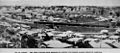
Passengers, leaving the New South Wales Railways carriage on the right side, transferring to a Queensland train on the left at Clapham Junction, Moorooka, probably during WW2
First train to Sydney passing Fairfield, 1930
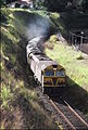
NSWR loco 8025 and another haul the Sydney bound 'Brisbane Limited' past the former Gloucester Road station site, 1987
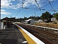
Fairfield railway station, 2012

QR loco 2400 hauls an empty Sunlander consist through Yeronga station (in order to turn the train), 1987. The station has since been replaced with a brick structure

NSWR loco 44216 and another haul the northbound 'Brisbane Limited' across the Corinda line at Yeerongpilly, 1987

QR loco 2493 hauls a short container train across the Standard Gauge line to Sydney at Yeerongpilly station, 1987. Note the Standard Gauge loco shed in the background
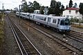
QR EMU unit 07 in original colour scheme on a Beenleigh bound train at Rocklea, ca.1987. Note the dual gauge rail on the third line


References
^ "Brisbane Suburb: Mount Gravatt - History of Mount Gravatt". ourbrisbane.com. 2000. Archived from the original on 21 January 2008. Retrieved 3 March 2008..mw-parser-output cite.citation{font-style:inherit}.mw-parser-output q{quotes:"""""""'""'"}.mw-parser-output code.cs1-code{color:inherit;background:inherit;border:inherit;padding:inherit}.mw-parser-output .cs1-lock-free a{background:url("//upload.wikimedia.org/wikipedia/commons/thumb/6/65/Lock-green.svg/9px-Lock-green.svg.png")no-repeat;background-position:right .1em center}.mw-parser-output .cs1-lock-limited a,.mw-parser-output .cs1-lock-registration a{background:url("//upload.wikimedia.org/wikipedia/commons/thumb/d/d6/Lock-gray-alt-2.svg/9px-Lock-gray-alt-2.svg.png")no-repeat;background-position:right .1em center}.mw-parser-output .cs1-lock-subscription a{background:url("//upload.wikimedia.org/wikipedia/commons/thumb/a/aa/Lock-red-alt-2.svg/9px-Lock-red-alt-2.svg.png")no-repeat;background-position:right .1em center}.mw-parser-output .cs1-subscription,.mw-parser-output .cs1-registration{color:#555}.mw-parser-output .cs1-subscription span,.mw-parser-output .cs1-registration span{border-bottom:1px dotted;cursor:help}.mw-parser-output .cs1-hidden-error{display:none;font-size:100%}.mw-parser-output .cs1-visible-error{font-size:100%}.mw-parser-output .cs1-subscription,.mw-parser-output .cs1-registration,.mw-parser-output .cs1-format{font-size:95%}.mw-parser-output .cs1-kern-left,.mw-parser-output .cs1-kern-wl-left{padding-left:0.2em}.mw-parser-output .cs1-kern-right,.mw-parser-output .cs1-kern-wl-right{padding-right:0.2em}
^ Armstrong, J. & Kerr, J. 'Destination South Brisbane' ARHS 1978
^ "THE FAIRFIELD DEVIATION". The Brisbane Courier. 7 August 1895.
^ Kerr, J. 'Triumph of Narrow Gauge' Boolarong Publications 1990
External links
| Wikimedia Commons has media related to Beenleigh railway line. |
- Queensland Rail
- Network map


