Ostrołęka
This article includes a list of references, but its sources remain unclear because it has insufficient inline citations. (September 2010) (Learn how and when to remove this template message) |
Ostrołęka | |||
|---|---|---|---|
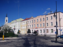
 Józef Bem Square (Polish: Plac Bema) | |||
| |||
 Ostrołęka Show map of Masovian Voivodeship  Ostrołęka Show map of Poland | |||
| Coordinates: 53°4′N 21°34′E / 53.067°N 21.567°E / 53.067; 21.567 | |||
| Country | |||
| Voivodeship | Masovian | ||
| County | city county | ||
| Established | 11th century | ||
| Town rights | 1373 | ||
| Government | |||
| • Mayor | Łukasz Kulik | ||
| Area | |||
| • Total | 33.46 km2 (12.92 sq mi) | ||
| Elevation | 92 m (302 ft) | ||
| Population (2014) | |||
| • Total | 52,792 | ||
| • Density | 1,600/km2 (4,100/sq mi) | ||
| Time zone | UTC+1 (CET) | ||
| • Summer (DST) | UTC+2 (CEST) | ||
| Postal code | 07-400 to 07-417 | ||
| Area code(s) | +48 029 | ||
| Vehicle registration plates | WO | ||
| Website | http://www.ostroleka.pl | ||

Town Hall

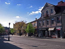
The Madalinski Bridge

Głowackiego Street
Ostrołęka [ɔstrɔˈwɛŋka] (![]() listen) is a city in northeastern Poland on the Narew river, about 120 km (75 mi) northeast of Warsaw, with a population of 52,792 (2014) and an area of 33,46 km2 (12,92 sq. mls). The town is situated in the Masovian Voivodeship (since 1999), and it is the former capital of the Ostrołęka Voivodeship (1975–1998). Ostrołęka is currently the capital of both Ostrołęka County and Ostrołęka City County. Until the late 1980s, Ostrołęka used to be a local railroad junction, with four lines stemming from Ostrołęka railway station: eastwards to Łapy and Białystok, southwestwards to Tłuszcz and Warsaw, northwards to Wielbark and Olsztyn, and southwards to Małkinia.
listen) is a city in northeastern Poland on the Narew river, about 120 km (75 mi) northeast of Warsaw, with a population of 52,792 (2014) and an area of 33,46 km2 (12,92 sq. mls). The town is situated in the Masovian Voivodeship (since 1999), and it is the former capital of the Ostrołęka Voivodeship (1975–1998). Ostrołęka is currently the capital of both Ostrołęka County and Ostrołęka City County. Until the late 1980s, Ostrołęka used to be a local railroad junction, with four lines stemming from Ostrołęka railway station: eastwards to Łapy and Białystok, southwestwards to Tłuszcz and Warsaw, northwards to Wielbark and Olsztyn, and southwards to Małkinia.
Contents
1 History
1.1 Founding
1.2 The 15th and 16th Centuries
1.3 The 17th Century
1.4 Kościuszko Uprising and Prussian Rule (1796-1806)
1.5 The Warsaw Duchy
1.6 Development during the period of the Polish Kingdom
1.7 1831-1918
1.8 Battle of Ostrołęka (1920)
1.9 Ostrołęka at the time of the Second World War
1.10 People's Republic of Poland
1.11 Ostrołęka since 1989
2 Education
3 Sport
3.1 Football
3.2 Volleyball
3.3 Handball
3.4 Basketball
4 Politics
4.1 Ostrołęka-Siedlce constituency
5 See also
6 External links
7 References
History
Founding
The city's name refers to a sand-mud plain located on the left side of the Narew River which regularly flooded in the springtime throughout the centuries. A small fort was built on an island in the 11th or 12th Century, currently located just one kilometer west of the modern city center. The fort was one of few sparsely built fortifications along the Narew River at the time. A village developed surrounding the fort over time, and is associated today as the initial settlement of Ostrołęka. Despite the lack of an exact date for Ostrołęka's founding, the village was first mentioned in the Province Act of 1373 by Prince Siemowit III of Masovia, and therefore, the year 1373 has become the most commonly associated date in terms of the city's founding.[citation needed]
The 15th and 16th Centuries
By the beginning of the 15th Century, Ostrołęka grew into an important economic center in the Duchy of Masovia for trade with the neighboring Teutonic Order. Wood, amber, and honey were the most commonly traded items. In 1526, the Duchy was incorporated into the Polish Kingdom. This resulted in an economic boom, most commonly associated to today as Ostrołęka's Golden Age. At this time, Queen Bona Sforza founded a folwark in Pomian – a neighboring settlement at the time, which currently finds itself situated well within the modern city's borders. The Golden Age lasted for approximately 40 years, whose conclusion is marked by three major catastrophes which struck in 1564 and 1571. In 1564, an epidemic seriously depopulated the town and surrounding regions. The same year, a fire tore through the town burning most of it down to the ground. In 1571, before the town had time to recuperate from the two previous catastrophes, another epidemic struck, further depopulating the region, officially marking the end of the town's Golden Age. Within 20 years, however, the town was rebuilt, including with the construction of Ostrołęka's first school. By the late 1590s, the town became the center of a big administrative district, approximately 1,980.5 km2 in size.[citation needed]
The 17th Century
Despite quickly recuperating in the early 17th Century, the town passed through a period of impoverishment and stagnation in the middle and late 17th Century. On 25 July 1656, in the midsts of the Deluge, the town was laid waste by Swedish forces after having resisted them. In 1665, Bernardine monks settled in the town after a monastery was founded by Tomasz Gocłowski. The Bernardine monastery of St. Anthony of Padua was built in a late-Baroque style.
Despite being inhabited by only 400 people in 1676, the town was still considered to be the most populous of towns in the Łomża region. In the following century, the town was destroyed numerous times by Swedish, Russian, and Saxon armies. As a result, further economic development was hindered and the town remained in a state of stagnation for over a century.[citation needed]
Kościuszko Uprising and Prussian Rule (1796-1806)
During the Kościuszko Uprising, the First Wielkopolska National Cavalry Brigade was stationed in Ostrołęka. With the aim of aiding the Kościuszko Uprising, the First Brigade, led by Antoni Madaliński, started to march towards Kraków on 12 March 1794. Prussian troops reacted quickly by heading as far south as the Narew River, and reached the town's northern outskirts on the right bank of the Narew River, yet had never marched directly into, nor fully occupied, the town. The Uprising had failed and as a consequence of the Third Partition of Poland two years later, Ostrołęka found itself within Prussia's borders for ten years. At the turn of the century, the first German and Jewish families began to settle in the town and surrounding areas.[citation needed]
The Warsaw Duchy
From the end of 1806 through June 1807, Ostrołęka was occupied by French troops. On 16 February 1807 occurred the Battle of Ostrołęka (1807). Taking place on the banks of the Narew outside of Ostrołęka where the French, under the General Nicolas Charles Oudinot, prevailed. Due to this success of the French Army, Ostrołęka appears on the Arc de Triomphe in Paris. In May 1807 the first map of Ostrołęka was made (now located in Bibliothéque du Génie in Paris).
Development during the period of the Polish Kingdom
As part of a comprehensive plan of industrializing Poland, an extensive settlement for linen and cotton craftsmen was built on the right bank of Narew in 1826. The number of craftsmen increased and workers were trained in new crafts. The town also built two bridges, one permanent. The new route connecting Warsaw and St. Petersburg ran through Ostrołęka. Although the town's citizens were eager and proud to take part in the November Uprising, they worried that their city, as in every previous war, would be destroyed. However they did not expect that the heaviest fighting would take place on near Ostrołęka.
According to the plans, the Polish Army was supposed to attack Russian Infantry Corps of the Tsar's Guard, which made camp between Augustów and Ostrołęka. On May 18, Ostrołęka was claimed by General Henryk Dembiński. But General Jan Zygmunt Skrzynecki didn't make a use of his temporary superiority and he couldn't make up his mind if to attack the Russians situated near Łomża. As a result, Łomża was destroyed.
On 26 May 1831, occurred the Battle of Ostrołęka (1831). As a cannonade was heard, Jan Zygmunt Skrzynecki couldn't believe that Hans Karl von Diebitsch (a Russian general) had already reached the suburbs of the city. He ordered the Fourth Infantry Regiment to defend the city. The main defending forces fortified themselves in the Bernadine Monastery. Unfortunately the Russians had brought cannons with them, quickly overpowering the Polish and forcing their surrender.[citation needed]
Von Diebitsch took over the city center, but the battle continued on the right side of the Narew. Skrzynecki and his troops valiantly defended the bridge wanting to hold back the Russian forces from crossing over to the other side of the river. Lieutenant-Colonel Józef Bem and his Fourth Battery were called in to help defend the bridge. Bem was able to hold back the Russians, but the battle is often referred to as a Polish defeat. The defeat began the end of the Uprising. As a result of the battle, 6000 Polish soldiers died including many Kurpie. Bem, for his bravery, was nominated as Commander-in-Chief of Artillery and was honoured with a Virtue Militari Cross. The battle was the greatest and the most bloodiest in the November Uprising.[citation needed]
1831-1918
After the Polish-Russian War, Ostrołęka became one of the most destroyed cities. Although it suffered great losses, Ostrołęka stayed a district city of Płock's Province. Ostrołęka's economy greatly declined. Nearly all the city's craftsmen became bankrupt. Only products of Ostrołęka's amber works were still supplied all over Europe. Ostrołęka got refunds from the Tsar's Treasury. However, it took a long time before it rose from its downfall. In 1847 a monument commemorating Russian Army's victory in the battle of Ostrołęka was raised on 26 May 1831. At the time of January's insurrection, no battles took place nearby Ostrołęka, as the Tsar placed a quite large Russian detachment in the city worrying of another Kurp Uprising. In 1864, after the Russian government's order, the Benedictines left Ostrołęka and the monastery buildings were placed under the parish-priest authority.[citation needed]
Until the First World War, the city managed to develop, but it was still a relatively unremarkable small town. The First World War destroyed its peaceful and monotonous character. Confiscation and forced labor devastated the economy caused rising prices for essential products, and generally caused the city to decline. In 1915, military operations in the territory of Polish Kingdom intensified. By July, the city was situated on the front line, and in August 1915, Germans crossed the river Narew and entered the ruined city. At the time of the German occupation, life in Ostrołęka was as hard as in the time of Russian occupation. Between the years of 1916 and 1918, the Germans greatly exploited the forests for timber. To make transporting the wood easier, they built 40 km (25 mi) of road from Ostrołęka to Myszyniec and a narrow-gauge railway line.
Battle of Ostrołęka (1920)
After the First World War, the city became a part of Białystok's province. 75% of the city and population was devastated. New schools and departments were opened as the city was rebuilt.
During the Polish-Soviet War, Ostrołęka once again became a center for military operations. On 4 August 1920, Soviet forces under the command of Hayk Bzhishkyan took the fort and "butchered the newly assembled cavalry group" of General Bolesław Roja.[1]:150 However, the Soviet occupation was short lived as the Soviet XV Army retreated on the 20th, with Polish forces thundering east towards the former Polish-Soviet border after the Battle of Warsaw (1920).[1]:205
After the Polish-Soviet War, Ostrołęka began to industrialize. A cinema was opened in 1923, and a power plant in 1928. During the summer of 1939, both sides of the Narew beachhead were fortified.
Ostrołęka at the time of the Second World War
On 10 September 1939 German forces reached Ostrołęka. Its name was changed to Scharfenwiese and the city was integrated into the Third Reich. Quickly, a resistance movement was established with a substantial presence of local Kurpes. Churches and schools were changed into workshops and factories controlled by the Underground. Underground Partisans started attacking and destroying German fortifications in and around Ostrołęka. A minority of citizens of Ostrołęka declared themselves as Volksdeutsche and signed the Volksliste. The majority of the Jewish population in Ostrołęka was murdered in Treblinka.[citation needed] Those that survived the Holocaust emigrated to Israel.[citation needed]
People's Republic of Poland
Ostrołęka recovered very slowly from the war. A plan created by communist authorities, which allowed for an improvement of the economic situation in Poland, gave Ostrołęka a chance for redevelopment. Ostrołęka became a central city of Warsaw's region. In 1959, a cellulose and paper factory was built. Next, a sewage refinery was built along the banks of the Narew, which was supposed to keep water in the Narew clean without destroying its biological life. In 1973 a cellular concrete factory was built in the district of Wojciechowice. New jobs brought people to the city and caused a development of alimentary industry. During the 1970s a new factory, "Future", producing wooden articles was opened. A new swimming pool, a stadium for 5000 people, and a holiday resort were built. A new hospital was built.
Ostrołęka since 1989
In 1989 the city entered a new era of capitalism, which has lasted until the present day. The same year Ostrołęka was granted provincial rights. The paper factory Cellulose downsized en masse after privatisation. The factory Future went bankrupt but small service establishments were opened for average people to invest their money. A new hospital was built in the new century. The economy also developed. Three new trade pavilions were built. "Cellulose" changed its name to "Intercell", and the cellular concrete factory was bought by the Ytong company. The centre of the city began to fulfill trade functions.[citation needed]
In 1996, a second permanent bridge, "Most im. Antoniego Madalińskiego", was built. In 1999 the city became a district city. A new aquapark was opened in September 2010. A modernisation of the city stadium or even a completely new stadium is planned to be built in this decade, while two new modern training grounds for football are currently being built. A new power plant is currently being built and planned to open by 2015, generating 1,000 MW of power.[2][3] Also, the existing power plant is planned to undergo modernisation in the next decade.[citation needed]

Education
- Wyższa Szkoła Administracji Publicznej
- Wyższa Szkoła Ekonomiczno-Społeczna
Sport
Football
Narew Ostrołęka - Soccer team established in 1962. Currently playing in the Ciechanów-Ostrołęka A-Class
- Korona Ostrołęka - Soccer team established in 1998. Currently playing in the 4th Masovian league, northern group
Volleyball
- Energa Net Ostrołęka - Male volleyball team currently playing in the 2nd Polish league
- OTPS Nike Ostrołęka - Female volleyball team currently playing in the 3rd Polish league
Handball
- Trójka Ostrołęka - Male handball team currently playing in the 2nd league
Basketball
- OTK Ostrołęka - Male basketball team
- OKK Ostrołęka - Male basketball team
- MUKS Unia Basket Ostrołęka - Female basketball team
Politics
Ostrołęka-Siedlce constituency
Members of Parliament (Sejm) elected from Ostrołęka-Siedlce constituency
- Chrzanowski Zbigniew, PO
- Deptuła Zbigniew, PSL
- Dziewulski Zbigniew, Samoobrona
- Filipek Krzysztof, Samoobrona
- Janowski Gabriel, LPR
- Kalinowski Jarosław, PSL
- Krutczenko Zbigniew, SLD-UP
- Kurpiewski Stanisław, SLD-UP
Oleksy Józef, SLD-UP- Piłka Marian, PiS
- Prządka Stanisława, SLD-UP
- Sawicki Marek, PSL
See also
- Kurpie
External links
| Wikimedia Commons has media related to Ostrołęka. |
- Your Virtual City
- interactive map
- Official Ostrołęka homepage
Jewish Community in Ostrołęka on Virtual Shtetl
References
^ ab Davies, N., 1972, White Eagle, Red Star, London: Macdonald & Co, .mw-parser-output cite.citation{font-style:inherit}.mw-parser-output q{quotes:"""""""'""'"}.mw-parser-output code.cs1-code{color:inherit;background:inherit;border:inherit;padding:inherit}.mw-parser-output .cs1-lock-free a{background:url("//upload.wikimedia.org/wikipedia/commons/thumb/6/65/Lock-green.svg/9px-Lock-green.svg.png")no-repeat;background-position:right .1em center}.mw-parser-output .cs1-lock-limited a,.mw-parser-output .cs1-lock-registration a{background:url("//upload.wikimedia.org/wikipedia/commons/thumb/d/d6/Lock-gray-alt-2.svg/9px-Lock-gray-alt-2.svg.png")no-repeat;background-position:right .1em center}.mw-parser-output .cs1-lock-subscription a{background:url("//upload.wikimedia.org/wikipedia/commons/thumb/a/aa/Lock-red-alt-2.svg/9px-Lock-red-alt-2.svg.png")no-repeat;background-position:right .1em center}.mw-parser-output .cs1-subscription,.mw-parser-output .cs1-registration{color:#555}.mw-parser-output .cs1-subscription span,.mw-parser-output .cs1-registration span{border-bottom:1px dotted;cursor:help}.mw-parser-output .cs1-hidden-error{display:none;font-size:100%}.mw-parser-output .cs1-visible-error{font-size:100%}.mw-parser-output .cs1-subscription,.mw-parser-output .cs1-registration,.mw-parser-output .cs1-format{font-size:95%}.mw-parser-output .cs1-kern-left,.mw-parser-output .cs1-kern-wl-left{padding-left:0.2em}.mw-parser-output .cs1-kern-right,.mw-parser-output .cs1-kern-wl-right{padding-right:0.2em}
ISBN 978-0-7126-0694-3
^
"Energa upgrading Ostroleka power station". Construction Sector in Poland. PMR. 2008-06-30. Retrieved 2010-12-04.
^
"Polish coal miner Bogdanka to supply Ostroleka power plant". Platts. 2010-10-20. Retrieved 2010-12-04.
Coordinates: 53°05′N 21°35′E / 53.083°N 21.583°E / 53.083; 21.583


