National Cycle Network
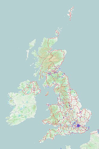
The NCN on OpenStreetMap

The first section of the NCN to be built was the Bristol & Bath Railway Path, opened in 1984

Route 8 sign near Harlech, North Wales
The National Cycle Network (NCN) is the national cycling route network of the United Kingdom, which was established to encourage cycling throughout Britain, as well as for the purposes of bicycle touring. It was created by the charity Sustrans who were aided by a £42.5 million National Lottery grant. The 14,000 mile network was used for over 230 million trips in 2005.
Little of the NCN is on dedicated bike paths. Though many routes try to minimise contact with motor traffic, 70% of them are on roads.[1] The NCN uses shared use paths, disused railways, minor roads, canal towpaths and traffic-calmed routes in towns and cities.
Contents
1 History
2 Routes
2.1 National routes
2.2 Numbering system
2.3 Signage
2.3.1 Mileposts
3 See also
4 References
5 Further reading
6 External links
History
The opening of the Bristol and Bath Railway Path (now part of National Route 4) in 1984, a 15-mile cycleway following a railway no longer in use, was the first part of the NCN.[2]
The original goal was to create 5,000 miles (8,000 km) of signed cycle routes by 2005,[2] with 50% of these not being on roads, and all of it being "suitable for an unsupervised twelve year old." By mid-2000, 5,000 miles (8,000 km) of route was signposted to an "interim" standard, and a new goal was then set to double that to 10,000 miles (16,000 km) by 2005. August 2005 saw the completion of that goal.
As of August 2014[update], there were 14,700 miles (23,700 km) of signed cycle route to NCN standards.[3]
Routes
National routes
There are ten national NCN routes; these are numbered from 1 to 10. As of 2018[update] they are not all complete.
Route 1: Dover – Shetland, along the east coast, via London, Edinburgh, John o' Groats and Orkney
Route 2: Dover – St Austell, along the south coast
Route 3: Bristol – Land's End, incorporating the West Country Way via Chew Valley Lake, and the Cornish Way
Route 4: London (Greenwich) – Fishguard, in West Wales, via Reading, Bath, Bristol, Newport, Caerphilly, Pontypridd, Swansea and Llanelli.
Route 5: Reading – Holyhead, via Birmingham, The Midlands and the North Wales coast
Route 6: Windsor – Lake District, via Luton, Milton Keynes, Northampton, Derby, Nottingham, Manchester and Preston crossing the Pennine Cycleway
Route 7: Carlisle – Inverness via Glasgow, incorporating the Clyde and Loch Lomond Cycleway
Route 8: Cardiff – Holyhead, through the heart of Wales. Also known as Lôn Las Cymru
Route 9: Belfast – Newry (proposed to run to Dublin)
Route 10: Tynemouth — Cockermouth. Was regional route 10 Reivers Cycle Route. Return route for the C2C / Sea to Sea Cycle Route. Roughly parallel to the C2C and Hadrian's Cycleway. It is a branch of National Route 1.
Numbering system
NCN routes beginning with numbers 1 to 6 are generally in England, the routes that begin with a 7 start in the far north of England and Scotland, with 8 are generally in Wales, and 9 in Northern Ireland. The main routes have one digit (1 to 6 radiate clockwise from the south of England); other routes have two digits, starting with the number of the relevant main route.
There are also many regional routes, reaching smaller towns and cities within ten designated regions. Each region is divided into a maximum of nine areas. Regional route numbers comprise the area number 1 to 9 followed by another digit. (An exception is in the Scottish Borders council area, where regional routes are numbered 1 to 9.) This means that across the UK there could be 10 regional route 12s, for instance, as well as the national route 12. To reduce confusion, identically numbered areas in adjacent regions do not abut, and routes with the same number are widely separated.
In 2009 regional routes were being renumbered with 3-digit national numbers.[4]
Routes are occasionally numbered to match the motorways and major roads that connect the same destinations; examples include NCN Route 62, which by connecting the two sides of the Pennines mirrors the M62 motorway.
Signage

A NCN "Millennium Milepost"
The network is signposted using a white bicycle symbol on a blue background, with a white route number in an inset box, but with no destination names or distances. National Route numbers have a red background, Regional Route numbers have a blue background. The system of symbols is based on that used by the Danish National Cycle Route network.
Mileposts
One thousand "Millennium Mileposts" made from cast iron were funded by the Royal Bank of Scotland to mark the creation of the National Cycle Network, and these are found along the NCN routes throughout the UK.

Millennium Milepost - Close-up (top) - geograph.org.uk - 303741
There are four different types: "Fossil Tree" (designed by John Mills), "The Cockerel" (designed by Iain McColl), "Rowe Type" (designed by Andrew Rowe), and "Tracks" (designed by David Dudgeon). The four artists are from each country of the UK, though all posts can be found in all four countries.[5][6]
Most mileposts contain a disk featuring symbols and text in code. There are 60 different designs, spread across the country. They form part of the Millennium Time Trail, a treasure hunt puzzle created by Sustrans in 2001.[7]
The Verse held within the coded text is:[citation needed]
.mw-parser-output .templatequote{overflow:hidden;margin:1em 0;padding:0 40px}.mw-parser-output .templatequote .templatequotecite{line-height:1.5em;text-align:left;padding-left:1.6em;margin-top:0}
MEASURE EVERY HEARTBEAT TO COUNT OUT OUR LIFE'S SCORE/
IS "TIME TO ESCAPE" MEANT TO FIRE OUR COMING AGE?/
LOCKED IN SEASONS' BARS SWINGS PENDULUM'S CEASELESS CLAW/
LUNGS NEVER FULL ENSNARE US IN TIME'S EIGHT PIECE CAGE/
ENTROPY'S AIM SHOOTS LEPTONS IN DANCING CYCLES OF LIGHT/
NATIONS REACH OUT IN HOPE ACROSS TIME ZONES AND LONG DEGREES/
NO CORNERS TO HIDE US, EARTH’S SHADE SPINS HOURLY ROUND TO NIGHT/
IN ALL MIND-STREAMS WE WADE, OUR WORLD-LINES WEAVE PAST TAPESTRIES/
UNCERTAIN DREAMS EVOLVE IN THE STRUGGLE FOR THE “WHY?”/
MUST IN ALL THESE TIDES OF FAITH, FLOW STILL SUCH WAVES OF FEARS?/
PLACE AND TIME TEMPT FATES, BUT ALL LIFE’S NATURE IS TO DIE/
OUR ERA, STARS, BOWS OUT, PLAYING ITS MUSICAL SPHERES/
EVERY GAINED UTOPIAN GOAL MAKES US MANIFOLD TIME’S TREASURE/
MAPPED OUT, AS ABOVE SO BELOW, NERGAL TICKS OFF TIME’S MEASURE///
See also
The National Byway, an alternative 4,500-mile (7,242 km) sign-posted cycle network around Britain- List of routes in Zone 4 of the National Cycle Network
- List of routes in Zone 8 of the National Cycle Network
References
^ "National Cycle Network". Essex Council. 2012. Archived from the original on 27 August 2012. Retrieved 24 September 2012..mw-parser-output cite.citation{font-style:inherit}.mw-parser-output q{quotes:"""""""'""'"}.mw-parser-output code.cs1-code{color:inherit;background:inherit;border:inherit;padding:inherit}.mw-parser-output .cs1-lock-free a{background:url("//upload.wikimedia.org/wikipedia/commons/thumb/6/65/Lock-green.svg/9px-Lock-green.svg.png")no-repeat;background-position:right .1em center}.mw-parser-output .cs1-lock-limited a,.mw-parser-output .cs1-lock-registration a{background:url("//upload.wikimedia.org/wikipedia/commons/thumb/d/d6/Lock-gray-alt-2.svg/9px-Lock-gray-alt-2.svg.png")no-repeat;background-position:right .1em center}.mw-parser-output .cs1-lock-subscription a{background:url("//upload.wikimedia.org/wikipedia/commons/thumb/a/aa/Lock-red-alt-2.svg/9px-Lock-red-alt-2.svg.png")no-repeat;background-position:right .1em center}.mw-parser-output .cs1-subscription,.mw-parser-output .cs1-registration{color:#555}.mw-parser-output .cs1-subscription span,.mw-parser-output .cs1-registration span{border-bottom:1px dotted;cursor:help}.mw-parser-output .cs1-hidden-error{display:none;font-size:100%}.mw-parser-output .cs1-visible-error{font-size:100%}.mw-parser-output .cs1-subscription,.mw-parser-output .cs1-registration,.mw-parser-output .cs1-format{font-size:95%}.mw-parser-output .cs1-kern-left,.mw-parser-output .cs1-kern-wl-left{padding-left:0.2em}.mw-parser-output .cs1-kern-right,.mw-parser-output .cs1-kern-wl-right{padding-right:0.2em}
^ ab Hesdin, Farah (29 November 2011). "The UK on a bicycle: the National Cycle Network". Bikenet.com. Archived from the original on 4 November 2012. Retrieved 24 September 2012.
^ "About the National Cycle Network". Sustrans. Retrieved 7 August 2014.
^ "Route numbering system". Sustrans website. Sustrans. Retrieved 12 December 2013.
^ "National Cycle Network Mileposts". Geograph Britain and Ireland website. Retrieved 12 December 2013.
^ "National Cycle Network - Art - Mileposts". Sustrans website. Sustrans. Retrieved 12 December 2013.
^ "Secrets of the Millennium Time Trail". Secrets of the Millennium Time Trail website. Retrieved 23 August 2015.
Further reading
- Sustrans, 2002. The Official Guide To The National Cycle Network, 2nd ed. Italy: Canile & Turin.
ISBN 1-901389-35-9.
External links
| Wikimedia Commons has media related to National Cycle Network. |
- Official website
- Sustrans' interactive map of the National Cycle Network
OpenCycleMap.org Worldwide cycle map based on OpenStreetMap data- Google Street View used to discover 'lost' cycle ways (BBC, 2017)


