Worcester County, Massachusetts
Worcester County, Massachusetts | ||
|---|---|---|
| County of Massachusetts | ||
| County of Worcester | ||
 Worcester County Courthouse | ||
| ||
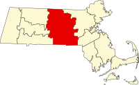 Location in the U.S. state of Massachusetts | ||
 Massachusetts's location in the U.S. | ||
| Founded | April 2, 1731 | |
| Seat | Worcester | |
| Largest city | Worcester | |
| Area | ||
| • Total | 1,579 sq mi (4,090 km2) | |
| • Land | 1,511 sq mi (3,913 km2) | |
| • Water | 68 sq mi (176 km2), 4.3% | |
| Population (est.) | ||
| • (2017) | 826,116[1] | |
| • Density | 529/sq mi (204/km2) | |
| Congressional districts | 1st, 2nd, 3rd, 4th, 5th | |
| Time zone | Eastern: UTC−5/−4 | |

Mount Wachusett, the highest point in Worcester County
Worcester County is a county located in the U.S. state of Massachusetts. As of the 2010 census, the population was 798,552,[2] making it the second-most populous county in Massachusetts while also being the largest in area. The estimated population as of July 1, 2017 is 826,116. The largest city and traditional county seat is the city of Worcester.[3]
Worcester County is included in the Worcester, MA-CT Metropolitan Statistical Area as well as the Boston-Worcester-Providence, MA-RI-NH-CT Combined Statistical Area.
Contents
1 History
2 Geography
2.1 Adjacent counties
2.2 National protected area
3 Demographics
3.1 2000 census
3.2 2010 census
3.3 Demographic breakdown by town
3.3.1 Income
4 Government and politics
5 Communities
5.1 Cities
5.2 Towns
5.3 Census-designated places
5.4 Other unincorporated communities
6 Ghost town
7 Notable people
8 See also
9 References
10 Further reading
11 External links
History
Worcester County was formed from the eastern portion of colonial Hampshire County, the western portion of the original Middlesex County and the extreme western portion of the original Suffolk County. When the government of Worcester County was established on April 2, 1731, Worcester was chosen as its shire town (later known as a county seat). From that date until the dissolution of the county government, it was the only county seat. Because of the size of the county, there were fifteen attempts over 140 years to split the county into two counties, but without success. Initially, Lancaster was proposed as the seat of the northern county; later, Petersham was proposed once and Fitchburg was proposed repeatedly, most recently in 1903. Perhaps as a concession, in August 1884 the Worcester County Registry of Deeds was split in two, with the Worcester Northern registry placed in Fitchburg.
Geography
According to the U.S. Census Bureau, the county has a total area of 1,579 square miles (4,090 km2), of which 1,511 square miles (3,910 km2) is land and 68 square miles (180 km2) (4.3%) is water.[4] It is the largest county in Massachusetts by area. The county is larger geographically than the entire state of Rhode Island even including Rhode Island's water ocean limit boundaries. The county constitutes Central Massachusetts, separating the Greater Springfield area from the Greater Boston area. It stretches from the northern to the southern border of the state. The geographic center of Massachusetts is in Rutland.
Worcester County is one of two Massachusetts counties that borders three different neighboring states; the other being Berkshire County. They are also the only two counties to touch both the northern and southern state lines.
Adjacent counties
Cheshire County, New Hampshire - north
Hillsborough County, New Hampshire - north/northeast
Middlesex County, Massachusetts - east/northeast
Norfolk County, Massachusetts - east/southeast
Providence County, Rhode Island - south/southeast
Windham County, Connecticut - south
Tolland County, Connecticut - south/southwest
Hampden County, Massachusetts - west/southwest
Hampshire County, Massachusetts - west
Franklin County, Massachusetts - west/northwest
National protected area
Oxbow National Wildlife Refuge (part)
Demographics
| Historical population | |||
|---|---|---|---|
| Census | Pop. | %± | |
| 1790 | 56,764 | — | |
| 1800 | 61,192 | 7.8% | |
| 1810 | 64,910 | 6.1% | |
| 1820 | 73,625 | 13.4% | |
| 1830 | 84,355 | 14.6% | |
| 1840 | 95,313 | 13.0% | |
| 1850 | 130,789 | 37.2% | |
| 1860 | 159,659 | 22.1% | |
| 1870 | 192,716 | 20.7% | |
| 1880 | 226,897 | 17.7% | |
| 1890 | 280,787 | 23.8% | |
| 1900 | 346,958 | 23.6% | |
| 1910 | 399,657 | 15.2% | |
| 1920 | 455,135 | 13.9% | |
| 1930 | 491,242 | 7.9% | |
| 1940 | 504,470 | 2.7% | |
| 1950 | 546,401 | 8.3% | |
| 1960 | 583,228 | 6.7% | |
| 1970 | 637,969 | 9.4% | |
| 1980 | 646,352 | 1.3% | |
| 1990 | 709,705 | 9.8% | |
| 2000 | 750,963 | 5.8% | |
| 2010 | 798,552 | 6.3% | |
| Est. 2017 | 826,116 | [5] | 3.5% |
| U.S. Decennial Census[6] 1790-1960[7] 1900-1990[8] 1990-2000[9] 2010-2013[2] | |||
In 1990 Worcester County had a population of 709,705.[10]
2000 census
As of the census[11] of 2000, there were 750,963 people, 283,927 households, and 192,502 families residing in the county. The population density was 496 people per square mile (192/km²). There were 298,159 housing units at an average density of 197 per square mile (76/km²). The racial makeup of the county was 89.61% White, 2.73% Black or African American, 0.25% Native American, 2.62% Asian, 0.04% Pacific Islander, 2.93% from other races, and 1.82% from two or more races. 6.77% of the population were Hispanic or Latino of any race. 15.9% were of Irish, 12.3% Italian, 11.7% French, 8.0% French Canadian, 8.0% English, 5.6% Polish and 5.0% American ancestry according to Census 2000. 85.1% spoke English, 6.1% Spanish and 1.9% French as their first language.
There were 283,927 households out of which 33.60% had children under the age of 18 living with them, 52.50% were married couples living together, 11.40% had a female householder with no husband present, and 32.20% were non-families. 26.20% of all households were made up of individuals and 10.40% had someone living alone who was 65 years of age or older. The average household size was 2.56 and the average family size was 3.11.
In the county, the population was spread out with 25.60% under the age of 18, 8.40% from 18 to 24, 31.10% from 25 to 44, 21.80% from 45 to 64, and 13.00% who were 65 years of age or older. The median age was 36 years. For every 100 females, there were 95.50 males. For every 100 females age 18 and over, there were 92.10 males.
The median income for a household in the county was $47,874, and the median income for a family was $58,394. Males had a median income of $42,261 versus $30,516 for females. The per capita income for the county was $22,983. About 6.80% of families and 9.20% of the population were below the poverty line, including 11.30% of those under age 18 and 9.50% of those age 65 or over.
2010 census
As of the 2010 United States Census, there were 798,552 people, 303,080 households, and 202,602 families residing in the county.[12] The population density was 528.6 inhabitants per square mile (204.1/km2). There were 326,788 housing units at an average density of 216.3 per square mile (83.5/km2).[13] The racial makeup of the county was 85.6% white, 4.2% black or African American, 4.0% Asian, 0.2% American Indian, 3.6% from other races, and 2.3% from two or more races. Those of Hispanic or Latino origin made up 9.4% of the population.[12] In terms of ancestry, 22.2% were Irish, 15.1% were French as well as 6.7% French Canadians, 14.4% were Italian, 11.7% were English, 7.0% were Polish, 6.9% were German, and 3.2% were American.[14]
Of the 303,080 households, 33.7% had children under the age of 18 living with them, 50.0% were married couples living together, 12.2% had a female householder with no husband present, 33.2% were non-families, and 26.2% of all households were made up of individuals. The average household size was 2.55 and the average family size was 3.09. The median age was 39.2 years.[12]
The median income for a household in the county was $64,152 and the median income for a family was $79,121. Males had a median income of $56,880 versus $42,223 for females. The per capita income for the county was $30,557. About 6.9% of families and 9.5% of the population were below the poverty line, including 12.1% of those under age 18 and 9.0% of those age 65 or over.[15]
Demographic breakdown by town
Income
The ranking of unincorporated communities that are included on the list are reflective of the census designated locations and villages were included as cities or towns. Data is from the 2007-2011 American Community Survey 5-Year Estimates.[16][17][18]
| Rank | Town | Per capita income | Median household income | Median family income | Population | Number of households | |
|---|---|---|---|---|---|---|---|
| 1 | Southborough | Town | $57,436 | $142,520 | $161,419 | 9,671 | 3,285 |
| 2 | Bolton | Town | $52,282 | $137,120 | $149,120 | 4,827 | 1,583 |
| 3 | Boylston | Town | $52,129 | $91,734 | $110,321 | 4,320 | 1,676 |
Cordaville | CDP | $51,707 | $151,836 | $175,217 | 2,558 | 845 | |
| 4 | Harvard | Town | $50,971 | $142,411 | $161,250 | 6,483 | 1,822 |
| 5 | Northborough | Town | $47,953 | $104,420 | $122,592 | 14,180 | 5,114 |
| 6 | Westborough | Town | $46,631 | $99,394 | $127,052 | 18,285 | 6,720 |
| 7 | Sterling | Town | $44,089 | $102,270 | $117,240 | 7,768 | 2,811 |
| 8 | Princeton | Town | $43,836 | $108,319 | $123,864 | 3,412 | 1,253 |
| 9 | Sutton | Town | $43,275 | $107,500 | $116,288 | 8,908 | 3,128 |
| 10 | Upton | Town | $43,252 | $110,083 | $132,703 | 7,364 | 2,588 |
| 11 | Berlin | Town | $41,503 | $94,712 | $99,375 | 2,819 | 1,029 |
Sturbridge | CDP | $41,479 | $77,692 | $93,167 | 2,027 | 860 | |
Westborough | CDP | $40,901 | $71,731 | $87,375 | 3,883 | 1,590 | |
| 12 | Mendon | Town | $40,523 | $93,245 | $108,173 | 5,787 | 2,055 |
| 13 | Hopedale | Town | $40,422 | $98,220 | $104,398 | 5,909 | 2,275 |
Barre | CDP | $39,556 | $77,602 | $102,650 | 1,053 | 418 | |
| 14 | Grafton | Town | $39,479 | $89,950 | $109,729 | 17,472 | 6,376 |
Northborough | CDP | $39,266 | $89,033 | $108,636 | 6,226 | 2,381 | |
Hopedale | CDP | $38,687 | $88,974 | $101,280 | 3,947 | 1,590 | |
| 15 | Holden | Town | $38,639 | $89,660 | $104,928 | 17,197 | 6,296 |
| 16 | Shrewsbury | Town | $38,223 | $88,985 | $104,035 | 35,269 | 13,095 |
| 17 | Sturbridge | Town | $37,480 | $79,044 | $98,693 | 9,133 | 3,655 |
| 18 | Paxton | Town | $37,328 | $105,072 | $106,625 | 4,767 | 1,591 |
Upton | CDP | $37,247 | $92,676 | $120,962 | 2,867 | 1,099 | |
| 19 | Douglas | Town | $35,931 | $81,000 | $97,383 | 8,342 | 3,206 |
| 20 | Lunenburg | Town | $35,868 | $83,265 | $95,000 | 10,034 | 3,728 |
Massachusetts | State | $35,051 | $65,981 | $83,371 | 6,512,227 | 2,522,409 | |
Lunenburg | CDP | $34,770 | $73,750 | $79,750 | 1,217 | 470 | |
| 21 | Lancaster | Town | $34,374 | $87,962 | $101,196 | 7,896 | 2,426 |
| 22 | Uxbridge | Town | $34,346 | $86,912 | $94,830 | 13,233 | 4,931 |
| 23 | Barre | Town | $33,647 | $73,687 | $93,250 | 5,383 | 2,065 |
| 24 | Millbury | Town | $33,467 | $77,883 | $86,855 | 13,250 | 5,166 |
| 25 | Auburn | Town | $33,447 | $73,559 | $87,958 | 16,183 | 6,318 |
| 26 | Charlton | Town | $33,250 | $91,653 | $98,789 | 12,827 | 4,306 |
| 27 | Blackstone | Town | $32,988 | $73,586 | $87,752 | 9,028 | 3,472 |
South Lancaster | CDP | $32,942 | $70,625 | $81,167 | 1,988 | 766 | |
| 28 | Ashburnham | Town | $32,880 | $81,842 | $98,056 | 6,033 | 2,184 |
| 29 | Hubbardston | Town | $32,618 | $83,333 | $95,203 | 4,341 | 1,538 |
| 30 | New Braintree | Town | $32,568 | $88,571 | $93,458 | 1,124 | 380 |
| 31 | Milford | Town | $32,219 | $64,860 | $80,127 | 27,925 | 10,493 |
| 32 | Royalston | Town | $32,031 | $59,609 | $73,125 | 1,058 | 455 |
| 33 | Hardwick | Town | $31,974 | $61,298 | $72,458 | 2,953 | 1,153 |
Worcester County | County | $31,470 | $65,772 | $81,342 | 794,981 | 299,089 | |
| 34 | Westminster | Town | $31,391 | $78,632 | $82,596 | 7,250 | 2,611 |
East Brookfield | CDP | $31,316 | $66,339 | $84,550 | 1,270 | 479 | |
| 35 | Oakham | Town | $31,237 | $79,700 | $83,676 | 1,822 | 680 |
| 36 | Rutland | Town | $30,961 | $83,734 | $101,486 | 7,812 | 2,558 |
| 37 | Northbridge | Town | $30,945 | $68,981 | $87,359 | 15,475 | 5,538 |
Milford | CDP | $30,678 | $60,840 | $72,927 | 25,194 | 9,494 | |
| 38 | Clinton | Town | $30,563 | $61,796 | $77,964 | 13,614 | 5,672 |
| 39 | Leicester | Town | $30,301 | $72,471 | $80,288 | 10,934 | 3,858 |
Fiskdale | CDP | $30,230 | $75,655 | $89,595 | 2,907 | 1,133 | |
| 40 | Oxford | Town | $30,149 | $68,567 | $83,161 | 13,702 | 5,343 |
| 41 | North Brookfield | Town | $30,106 | $64,009 | $76,690 | 4,686 | 1,931 |
| 42 | West Brookfield | Town | $29,782 | $62,685 | $84,868 | 3,730 | 1,488 |
East Douglas | CDP | $29,760 | $73,372 | $74,828 | 2,835 | 1,146 | |
| 43 | Spencer | Town | $29,687 | $59,420 | $77,384 | 11,715 | 4,686 |
| 44 | East Brookfield | Town | $29,416 | $62,350 | $82,750 | 2,058 | 737 |
| 45 | Brookfield | Town | $29,392 | $62,390 | $77,993 | 3,363 | 1,353 |
| 46 | Millville | Town | $29,049 | $73,426 | $84,000 | 3,154 | 1,060 |
West Brookfield | CDP | $28,704 | $56,625 | $95,556 | 1,853 | 705 | |
| 47 | West Boylston | Town | $28,547 | $73,600 | $89,681 | 7,660 | 2,308 |
| 48 | Leominster | City | $28,445 | $58,585 | $73,704 | 40,884 | 16,095 |
| 49 | Phillipston | Town | $28,273 | $74,043 | $75,234 | 1,894 | 648 |
North Brookfield | CDP | $28,163 | $50,346 | $64,181 | 2,035 | 912 | |
| 50 | Warren | Town | $28,112 | $51,188 | $69,873 | 5,106 | 2,067 |
Oxford | CDP | $27,990 | $67,054 | $79,832 | 6,566 | 2,418 | |
United States | Country | $27,915 | $52,762 | $64,293 | 306,603,772 | 114,761,359 | |
South Ashburnham | CDP | $27,758 | $76,932 | $77,386 | 1,104 | 345 | |
| 51 | Petersham | Town | $27,475 | $65,781 | $81,250 | 1,263 | 445 |
| 52 | Webster | Town | $27,430 | $49,621 | $65,204 | 16,752 | 7,344 |
| 53 | Dudley | Town | $27,319 | $72,500 | $78,920 | 11,276 | 3,780 |
Whitinsville | CDP | $27,135 | $58,846 | $62,314 | 6,894 | 2,424 | |
Spencer | CDP | $27,059 | $47,183 | $66,932 | 5,392 | 2,417 | |
| 54 | Templeton | Town | $26,891 | $70,116 | $75,753 | 7,896 | 2,846 |
Baldwinville | CDP | $26,585 | $66,700 | $77,061 | 2,061 | 750 | |
Clinton | CDP | $26,256 | $54,514 | $72,859 | 7,492 | 3,032 | |
Rutland | CDP | $25,987 | $62,500 | $78,929 | 2,352 | 758 | |
| 55 | Winchendon | Town | $25,845 | $58,137 | $73,162 | 10,250 | 3,743 |
Warren | CDP | $25,245 | $41,200 | $71,722 | 1,408 | 564 | |
| 56 | Gardner | City | $24,974 | $48,108 | $63,413 | 20,323 | 8,037 |
| 57 | Worcester | City | $24,544 | $45,846 | $55,927 | 180,519 | 70,248 |
| 58 | Athol | Town | $24,384 | $50,866 | $59,095 | 11,576 | 4,551 |
Webster | CDP | $24,109 | $43,702 | $53,145 | 11,682 | 5,195 | |
| 59 | Fitchburg | City | $24,061 | $48,064 | $55,293 | 40,286 | 14,741 |
| 60 | Southbridge | City | $21,923 | $43,965 | $52,577 | 16,800 | 6,548 |
Winchendon | CDP | $21,914 | $36,711 | $52,868 | 3,860 | 1,638 | |
Athol | CDP | $21,553 | $47,330 | $52,139 | 7,867 | 3,150 | |
Devens | CDP | $13,933 | $72,986 | $73,194 | 1,704 | 113 |
Government and politics
| County-level state agency heads | |
|---|---|
Clerk of Courts: | Dennis P. McManus (D) |
District Attorney: | Joseph D. Early, Jr. (D) |
Register of Deeds: | Anthony J. Vigliotti (D) |
Register of Probate: | Stephanie K. Fattman (R) |
County Sheriff: | Lew Evangelidis (R) |
| State government | |
State Representative(s): | by community |
State Senator(s): | by community |
Governor's Councilor(s): | Jen Caissie (R) |
| Federal government | |
U.S. Representative(s): | by Congressional district |
U.S. Senators: | Elizabeth Warren (D), Ed Markey (D) |
Worcester County is one of 8[19] of the 14 Massachusetts counties, which has had no county government or county commissioners since July 1, 1998, when county functions were assumed by state agencies at local option following a change in state law.[20] The County has an elected county sheriff, county prosecutor, and court officials, administered under the state department of public safety. The state correctional system in the County is known as the Worcester County Jail or "House of Corrections" at West Boylston, and the Worcester County District courts (state administered) are housed at Worcester, Fitchburg and other district courts within county boundaries.[20] The Worcester County district attorney is a county-wide position even though the district includes one town from a neighboring county. In Massachusetts, Sheriffs have more limited roles than most states and are responsible for corrections, court service and bailiffs and jail release programs.[20] County Sheriffs in Massachusetts are elected to six-year terms.[20] The Worcester County Sheriff is Lewis Evangelidis, (R), and the Worcester County District Attorney is Joseph Early (D).(see the info-box at lower right for elected officials at county level). The Worcester County 4 H fair is in its 63rd year in 2014 with the fairgrounds at Spencer. Worcester County has one commercial airport at Worcester. The Worcester County Conservation District has countywide boundaries.[21] The County has a regional planning commission.
Massachusetts law allows regional compacts, traditional counties and other governmental entities.[20] Traditional County governments in the state include: Norfolk, Bristol, Dukes, Nantucket, and Plymouth Counties. Barnstable County, which is Cape Cod, functions as a modern regional county government. Suffolk County which is mainly Boston is under the Boston City Council. The Massachusetts General Laws describe this relationship of county government and the options for abolishing county governments and/or chartering regional governmental compacts in subchapter 34 B.[20] Four other new county compacts have been created by the state legislature and these are in Hampshire, Franklin, Barnstable Counties, and a regional planning council level for Berkshire County. Thus 9 of 14 Counties have some form of county regional governments. Worcester County could exercise that option if it chooses for example, for public safety and, or preparedness due to its rather large geography, by a request to and a special act of the legislature, by local referendum or by one of three mechanisms. See the references for the state statute, and the League of Women Voters link.
| Voter registration and party enrollment as of October 15, 2008[22] | |||||
|---|---|---|---|---|---|
| Party | Number of voters | Percentage | |||
Democratic | 156,454 | 30.65% | |||
Republican | 66,466 | 13.02% | |||
| Unenrolled | 283,517 | 55.54% | |||
| Minor Parties | 4,015 | 0.79% | |||
| Total | 510,452 | 100% | |||
| Year | Republican | Democratic | Third parties |
|---|---|---|---|
2016 | 40.4% 157,682 | 51.0% 198,778 | 8.6% 33,491 |
2012 | 44.3% 163,390 | 53.7% 198,244 | 2.0% 7,478 |
2008 | 41.8% 152,101 | 55.6% 202,107 | 2.6% 9,386 |
2004 | 42.3% 144,094 | 56.4% 192,142 | 1.3% 4,400 |
2000 | 36.8% 114,139 | 56.0% 173,769 | 7.2% 22,240 |
1996 | 29.8% 87,021 | 58.3% 169,892 | 11.9% 34,704 |
1992 | 32.3% 101,984 | 43.7% 138,122 | 24.0% 75,676 |
1988 | 50.6% 148,365 | 48.3% 141,485 | 1.2% 3,406 |
1984 | 56.5% 156,060 | 43.2% 119,498 | 0.3% 882 |
1980 | 43.1% 120,100 | 42.1% 117,326 | 14.8% 41,135 |
1976 | 36.9% 105,217 | 60.4% 172,320 | 2.7% 7,708 |
1972 | 46.7% 127,560 | 52.8% 144,139 | 0.5% 1,428 |
1968 | 33.3% 88,354 | 63.5% 168,437 | 3.2% 8,388 |
1964 | 22.6% 61,388 | 77.1% 209,383 | 0.3% 860 |
1960 | 39.4% 112,730 | 60.5% 173,103 | 0.2% 500 |
1956 | 60.1% 163,401 | 39.7% 107,889 | 0.2% 580 |
1952 | 53.0% 146,094 | 46.8% 128,898 | 0.2% 645 |
1948 | 43.6% 106,757 | 54.7% 133,823 | 1.7% 4,177 |
1944 | 44.3% 98,414 | 55.5% 123,440 | 0.2% 404 |
1940 | 42.9% 100,468 | 56.6% 132,541 | 0.5% 1,099 |
1936 | 40.5% 85,316 | 54.2% 114,136 | 5.4% 11,312 |
1932 | 49.1% 88,535 | 48.6% 87,586 | 2.4% 4,281 |
1928 | 52.1% 94,290 | 47.3% 85,675 | 0.6% 1,045 |
1924 | 67.1% 89,679 | 23.3% 31,171 | 9.5% 12,726 |
1920 | 68.6% 81,241 | 29.3% 34,667 | 2.1% 2,464 |
1916 | 52.8% 32,541 | 44.7% 27,540 | 2.6% 1,599 |
1912 | 42.1% 24,719 | 29.9% 17,565 | 28.1% 16,492 |
1908 | 62.1% 34,394 | 30.3% 16,803 | 7.6% 4,228 |
1904 | 63.8% 34,124 | 31.9% 17,037 | 4.3% 2,300 |
1900 | 62.8% 32,412 | 33.2% 17,148 | 3.9% 2,022 |
1896 | 73.4% 35,579 | 22.4% 10,855 | 4.3% 2,059 |
1892 | 54.8% 27,130 | 42.0% 20,797 | 3.1% 1,544 |
1888 | 56.3% 25,005 | 40.4% 17,930 | 3.4% 1,502 |
1884 | 55.3% 21,661 | 32.5% 12,712 | 12.2% 4,783 |
1880 | 63.2% 23,040 | 35.2% 12,852 | 1.6% 583 |
1876 | 60.4% 22,054 | 39.2% 14,319 | 0.3% 123 |
Communities
Cities
- Fitchburg
- Gardner
- Leominster
- Southbridge
Worcester (traditional county seat)
Towns
- Ashburnham
- Athol
- Auburn
- Barre
- Berlin
- Blackstone
- Bolton
- Boylston
- Brookfield
- Charlton
- Clinton
- Douglas
- Dudley
- East Brookfield
- Grafton
- Hardwick
- Harvard
- Holden
- Hopedale
- Hubbardston
- Lancaster
- Leicester
- Lunenburg
- Mendon
- Milford
- Millbury
- Millville
- New Braintree
- North Brookfield
- Northborough
- Northbridge
- Oakham
- Oxford
- Paxton
- Petersham
- Phillipston
- Princeton
- Royalston
- Rutland
- Shrewsbury
- Southborough
- Spencer
- Sterling
- Sturbridge
- Sutton
- Templeton
- Upton
- Uxbridge
- Warren
- Webster
- West Boylston
- West Brookfield
- Westborough
- Westminster
- Winchendon
Census-designated places
- Athol
- Baldwinville
- Barre
- Brookfield
- Clinton
- Cordaville
- Devens
- East Brookfield
- East Douglas
- Fiskdale
- Hopedale
- Lunenburg
- Milford
- North Brookfield
- Northborough
- Oxford
- Petersham
- Rutland
- South Ashburnham
- South Lancaster
- Spencer
- Sturbridge
- Upton
- Warren
- Webster
- West Brookfield
- Westborough
- Whitinsville
- Winchendon
Other unincorporated communities
- Chapinville
- Cherry Valley
- East Millbury
- East Princeton
Farnumsville (also called South Grafton)- Fisherville
- Gilbertville
- Hardwick
Ironstone (also known as South Uxbridge)- Jefferson
- Leicester Center
- Linwood
- Manchuag
- Morningdale
- North Grafton
- North Uxbridge
- Oakdale
- Old Furnace
- Otter River
- Pitcherville
- Rochdale
- Rockdale
- Saundersville
- Spindleville
- Still River
- Stoneville
- Union Chapel
- Upton-West Upton
- West Sutton
- Whalom
- Wheelockville
- Wheelwright
- Winchendon Springs
Ghost town
- Dana
Notable people
Louisa May Alcott, novelist, daughter of Amos Alcott
Johnny Appleseed, real name Jonathan Chapman
Mike Barnicle, newspaper writer
Clara Barton, founder of the American Red Cross
Michael Beasley, NBA player, high school All-American; attended Notre Dame Preparatory School
Robert Benchley, writer, theater critic, actor, humorist, and member of the Algonquin Round Table
H. Jon Benjamin, actor and comedian
Ezra T. Benson, Mormon pioneer, missionary, Quorum of Twelve, and Utah territorial legislator
Ken Bouchard and Ron Bouchard, NASCAR drivers
Luther Burbank, horticulturalist; developed russet potato used in French fries by McDonald's
William Cullen Bryant, poet, journalist and editor of the New York Evening Post
Effingham Capron, woolen and cotton mill scion who liberated slaves from the 1830s; led local, state and US anti slavery societies
George M. Cohan, entertainer, playwright, composer, lyricist, actor, singer, dancer, director
Robert Cormier, novelist and columnist
Ron Darling, professional baseball pitcher, World Series player; local St. Johns High School star from Millbury, born in Honolulu
Dorothea Dix, social reformer; activist
Ralph Earl, famous portrait painter, artist of early America
Fannie Farmer, cookbook author
Abby Kelley Foster, radical abolitionist, women's suffrage
Robert H. Goddard, father of American rocketry
Ryan Gomes, NBA player; attended Notre Dame Preparatory School
Gabby Hartnett, greatest baseball catcher before Johnny Bench
Abbie Hoffman, activist
Elias Howe, invented the sewing machine
Elliott P. Joslin, pioneer diabetes researcher and clinician; founded Joslin Clinic
Walker Lewis, black abolitionist, Masonic Grand Master of African Grand Lodge #1, Mormon elder
Connie Mack, baseball great and long-time baseball manager
Nora Marlowe, character actress; best known for role on The Waltons
Agnes Moorehead, actress
William T. G. Morton, contributor to modern anaesthesia
Francis Patrick O'Connor, associate justice on Massachusetts Supreme Court
Frank O'Hara, avant-garde poet and playwright
Jeannine Oppewall, Hollywood producer, film art, four Academy Award nominations including Bridges of Madison County
Joe Perry, songwriter and guitarist with Aerosmith; he was from Hopedale, and played his first gig at Mendon
Amos Singletary, Anti-Federalist mill operator, justice for the peace, and state representative
Brian Skerry, underwater photographer for National Geographic
Steve Spagnuolo, former head coach of the St. Louis Rams, currently the defensive coordinator for the New York Giants
Lysander Spooner, pamphleteer, lawyer, abolitionist and political theorist
Lucy Stone, famous suffragette, women's rights advocate, abolitionist, public speaker, first woman college grad in Massachusetts; first woman to retain her own name after marriage
Lydia Chapin Taft, America's first woman voter; first colonial woman who voted legally in America
Earl Tupper, a New Hampshire native, who pioneered Tupperware in Farnumsville, South Grafton, in the 1940s[24]
Hiram Walker, distillery founder
Artemas Ward, major general of the American Revolution; the first Supreme Allied Commander of the Continental Army
Daniel B. Wesson, co-founder of Smith & Wesson, a major firearm manufacturer
Eli Whitney, invented the cotton gin
Scott Young, NHL professional hockey player, two-time Stanley Cup champion, United States Olympian; attended St. Mark's and Boston University
Geoffrey Zakarian, Iron Chef and restaurateur
See also
Registry of Deeds (Massachusetts) Worcester County District Registry of Deeds- National Register of Historic Places listings in Worcester County, Massachusetts
References
^ "U.S. Census Bureau QuickFacts: Worcester County, Massachusetts". Census Bureau QuickFacts..mw-parser-output cite.citation{font-style:inherit}.mw-parser-output q{quotes:"""""""'""'"}.mw-parser-output code.cs1-code{color:inherit;background:inherit;border:inherit;padding:inherit}.mw-parser-output .cs1-lock-free a{background:url("//upload.wikimedia.org/wikipedia/commons/thumb/6/65/Lock-green.svg/9px-Lock-green.svg.png")no-repeat;background-position:right .1em center}.mw-parser-output .cs1-lock-limited a,.mw-parser-output .cs1-lock-registration a{background:url("//upload.wikimedia.org/wikipedia/commons/thumb/d/d6/Lock-gray-alt-2.svg/9px-Lock-gray-alt-2.svg.png")no-repeat;background-position:right .1em center}.mw-parser-output .cs1-lock-subscription a{background:url("//upload.wikimedia.org/wikipedia/commons/thumb/a/aa/Lock-red-alt-2.svg/9px-Lock-red-alt-2.svg.png")no-repeat;background-position:right .1em center}.mw-parser-output .cs1-subscription,.mw-parser-output .cs1-registration{color:#555}.mw-parser-output .cs1-subscription span,.mw-parser-output .cs1-registration span{border-bottom:1px dotted;cursor:help}.mw-parser-output .cs1-hidden-error{display:none;font-size:100%}.mw-parser-output .cs1-visible-error{font-size:100%}.mw-parser-output .cs1-subscription,.mw-parser-output .cs1-registration,.mw-parser-output .cs1-format{font-size:95%}.mw-parser-output .cs1-kern-left,.mw-parser-output .cs1-kern-wl-left{padding-left:0.2em}.mw-parser-output .cs1-kern-right,.mw-parser-output .cs1-kern-wl-right{padding-right:0.2em}
^ ab "State & County QuickFacts". United States Census Bureau. Retrieved August 26, 2013.
^ "Find a County". National Association of Counties. Archived from the original on May 31, 2011. Retrieved 2011-06-07.
^ "2010 Census Gazetteer Files". United States Census Bureau. August 22, 2012. Archived from the original on September 14, 2014. Retrieved September 16, 2014.
^ "Population and Housing Unit Estimates". Retrieved June 9, 2017.
^ "U.S. Decennial Census". United States Census Bureau. Archived from the original on May 12, 2015. Retrieved September 16, 2014.
^ "Historical Census Browser". University of Virginia Library. Retrieved September 16, 2014.
^ "Population of Counties by Decennial Census: 1900 to 1990". United States Census Bureau. Retrieved September 16, 2014.
^ "Census 2000 PHC-T-4. Ranking Tables for Counties: 1990 and 2000" (PDF). United States Census Bureau. Retrieved September 16, 2014.
^ Census Worcester County Basic Fact Sheet
^ "American FactFinder". United States Census Bureau. Retrieved 2008-01-31.
^ abc "DP-1 Profile of General Population and Housing Characteristics: 2010 Demographic Profile Data". United States Census Bureau. Retrieved 2016-01-12.
^ "Population, Housing Units, Area, and Density: 2010 - County". United States Census Bureau. Retrieved 2016-01-12.
^ "DP02 SELECTED SOCIAL CHARACTERISTICS IN THE UNITED STATES – 2006-2010 American Community Survey 5-Year Estimates". United States Census Bureau. Retrieved 2016-01-12.
^ "DP03 SELECTED ECONOMIC CHARACTERISTICS – 2006-2010 American Community Survey 5-Year Estimates". United States Census Bureau. Retrieved 2016-01-12.
^ "SELECTED ECONOMIC CHARACTERISTICS 2007-2011 American Community Survey 5-Year Estimates". U.S. Census Bureau. Retrieved 2013-01-26.
^ "ACS DEMOGRAPHIC AND HOUSING ESTIMATES 2007-2011 American Community Survey 5-Year Estimates". U.S. Census Bureau. Retrieved 2013-01-26.
^ "HOUSEHOLDS AND FAMILIES 2007-2011 American Community Survey 5-Year Estimates". U.S. Census Bureau. Retrieved 2013-01-26.
^ "General Laws of Massachusetts, Chapter 34B. Abolition of County Government". Massachusetts General Court. Retrieved November 26, 2016.
^ abcdef Mass. Gen. L. c. 34B
^ Worcester County Conservation District
^ "Registration and Party Enrollment Statistics as of October 15, 2008" (PDF). Massachusetts Elections Division. Retrieved 2010-05-08.
^ Leip, David. "Dave Leip's Atlas of U.S. Presidential Elections". uselectionatlas.org. Retrieved 2018-08-27.
^ Dempsey, James (March 4, 1992). "Many Changes Since Tupper Started Ware". Worcester Telegram and Gazette. Retrieved August 11, 2011.
Further reading
- Mary Babson Fuhrer, A Crisis of Community: The Trials and Transformation of a New England Town, 1815-1848. Chapel Hill, NC: University of North Carolina Press, 2014.
The Worcester County Directory, Boston, Mass.: Briggs & Co., 1878
External links
| Wikimedia Commons has media related to Worcester County, Massachusetts. |
Wikisource has the text of an 1879 American Cyclopædia article about Worcester County, Massachusetts. |
- Worcester County Sheriff
- Worcester County District Attorney's Office
- Worcester District Registry of Deeds
- League of Women Voters page on counties
- Map of cities and towns of Massachusetts
- Video guide to Worcester County (Worcester Love)
- Hampshire Council of Governments
- Worcester County 4 H Fair
- Worcester County Conservation District
Places adjacent to Worcester County, Massachusetts | ||||||||||
|---|---|---|---|---|---|---|---|---|---|---|
| ||||||||||
Municipalities and communities of Worcester County, Massachusetts, United States | ||
|---|---|---|
County seat: Worcester | ||
| Cities |
|  |
| Towns |
| |
| CDPs |
| |
| Other villages |
| |
| Ghost town |
| |
| Indian reservation |
| |
Boston (capital) | |
| Topics |
|
| Society |
|
| Regions |
|
| Counties |
|
| Cities |
|
Coordinates: 42°21′N 71°55′W / 42.35°N 71.91°W / 42.35; -71.91


