Bernisse
Bernisse | ||
|---|---|---|
Former municipality | ||
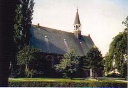 Church in Oudenhoorn | ||
| ||
 Location in South Holland | ||
| Coordinates: 51°51′N 4°15′E / 51.850°N 4.250°E / 51.850; 4.250Coordinates: 51°51′N 4°15′E / 51.850°N 4.250°E / 51.850; 4.250 | ||
| Country | Netherlands | |
| Province | South Holland | |
| Municipality | Nissewaard | |
| Area [1] | ||
| • Total | 68.46 km2 (26.43 sq mi) | |
| • Land | 57.34 km2 (22.14 sq mi) | |
| • Water | 11.12 km2 (4.29 sq mi) | |
| Elevation [2] | 0 m (0 ft) | |
| Population (August 2017)[3] | ||
| • Total | data missing | |
| Time zone | UTC+1 (CET) | |
| • Summer (DST) | UTC+2 (CEST) | |
| Postcode | 3211–3218, 3227 | |
| Area code | 0181 | |
| Website | www.gemeentebernisse.nl | |

Bernisse (![]() pronunciation (help·info)) is a former municipality in the western Netherlands, in the province of South Holland. Since 2015 it has been a part of the municipality of Nissewaard.
pronunciation (help·info)) is a former municipality in the western Netherlands, in the province of South Holland. Since 2015 it has been a part of the municipality of Nissewaard.
The former municipality had a population of data missing in 2017, and covered an area of 68.46 km2 (26.43 sq mi) of which 11.12 km2 (4.29 sq mi) was water.
The former municipality was named after the river Bernisse, which flows right through it from the Spui to the Brielse meer and separates the estuary islands of Voorne and Putten.
The former municipality of Bernisse consisted of the following communities: Abbenbroek, Biert, Geervliet, Heenvliet, Oudenhoorn, Simonshaven, Zuidland.
The municipality of Bernisse was formed on January 1, 1980, through the amalgamation of the municipalities Abbenbroek, Oudenhoorn, Zuidland, and parts of the municipalities Geervliet (including Simonshaven) and Heenvliet.

Satellite image of the Rhine-Meuse delta showing the Bernisse river (q) and the islands of Voorne (4) and Putten (5)
Topography
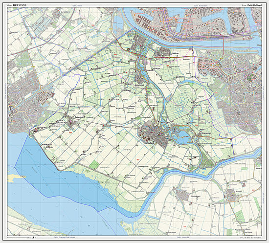
Dutch Topographic map of the former municipality of Bernisse, 2013.
References
^ "Kerncijfers wijken en buurten" [Key figures for neighbourhoods]. CBS Statline (in Dutch). CBS. 2 July 2013. Retrieved 12 March 2014..mw-parser-output cite.citation{font-style:inherit}.mw-parser-output q{quotes:"""""""'""'"}.mw-parser-output code.cs1-code{color:inherit;background:inherit;border:inherit;padding:inherit}.mw-parser-output .cs1-lock-free a{background:url("//upload.wikimedia.org/wikipedia/commons/thumb/6/65/Lock-green.svg/9px-Lock-green.svg.png")no-repeat;background-position:right .1em center}.mw-parser-output .cs1-lock-limited a,.mw-parser-output .cs1-lock-registration a{background:url("//upload.wikimedia.org/wikipedia/commons/thumb/d/d6/Lock-gray-alt-2.svg/9px-Lock-gray-alt-2.svg.png")no-repeat;background-position:right .1em center}.mw-parser-output .cs1-lock-subscription a{background:url("//upload.wikimedia.org/wikipedia/commons/thumb/a/aa/Lock-red-alt-2.svg/9px-Lock-red-alt-2.svg.png")no-repeat;background-position:right .1em center}.mw-parser-output .cs1-subscription,.mw-parser-output .cs1-registration{color:#555}.mw-parser-output .cs1-subscription span,.mw-parser-output .cs1-registration span{border-bottom:1px dotted;cursor:help}.mw-parser-output .cs1-hidden-error{display:none;font-size:100%}.mw-parser-output .cs1-visible-error{font-size:100%}.mw-parser-output .cs1-subscription,.mw-parser-output .cs1-registration,.mw-parser-output .cs1-format{font-size:95%}.mw-parser-output .cs1-kern-left,.mw-parser-output .cs1-kern-wl-left{padding-left:0.2em}.mw-parser-output .cs1-kern-right,.mw-parser-output .cs1-kern-wl-right{padding-right:0.2em}
^ "Postcodetool for 3216AG". Actueel Hoogtebestand Nederland (in Dutch). Het Waterschapshuis. Retrieved 14 July 2013.
^ "Bevolkingsontwikkeling; regio per maand" [Population growth; regions per month]. CBS Statline (in Dutch). CBS. 27 October 2017. Retrieved 27 October 2017.
External links
| Wikimedia Commons has media related to Bernisse. |
- Official website
Places adjacent to Bernisse | ||||||||||
|---|---|---|---|---|---|---|---|---|---|---|
| ||||||||||
This South Holland location article is a stub. You can help Wikipedia by expanding it. |


