Spijkenisse
Spijkenisse | |||
|---|---|---|---|
Town and former municipality | |||
 Square in Spijkenisse | |||
| |||
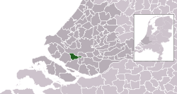 Location in South Holland | |||
| Coordinates: 51°51′N 4°20′E / 51.850°N 4.333°E / 51.850; 4.333Coordinates: 51°51′N 4°20′E / 51.850°N 4.333°E / 51.850; 4.333 | |||
| Country | Netherlands | ||
| Province | South Holland | ||
| Municipality | Nissewaard | ||
| Area [1] | |||
| • Total | 30.27 km2 (11.69 sq mi) | ||
| • Land | 26.12 km2 (10.08 sq mi) | ||
| • Water | 4.15 km2 (1.60 sq mi) | ||
| Elevation [2] | −1 m (−3 ft) | ||
| Population | |||
| • Total | 72,500 | ||
| Demonym(s) | Spijkenissenaar | ||
| Time zone | UTC+1 (CET) | ||
| • Summer (DST) | UTC+2 (CEST) | ||
| Postcode | 3200–3209 | ||
| Area code | 0181 | ||
| Website | www.nissewaard.nl | ||


Dutch Topographic map of Spijkenisse (place), as of Sept. 2014
Spijkenisse (Dutch pronunciation: [spɛi̯kəˈnɪsə] (![]() listen)) is a town in the western Netherlands, in the province of South Holland. After an administrative reform in 2015 it is part of the municipality of Nissewaard.
listen)) is a town in the western Netherlands, in the province of South Holland. After an administrative reform in 2015 it is part of the municipality of Nissewaard.
The town had a population of 72,500 in 2015, and covered an area of 30.27 km2 (11.69 sq mi) of which 4.15 km2 (1.60 sq mi) was water. It is part of the Greater Rotterdam Area.
The town also included the communities of Hekelingen, Den Hoek and Beerenplaat.
Contents
1 History
2 Public transportation
3 Districts
4 Health
5 Schools
5.1 Primary schools
5.2 Secondary school
6 Notable residents
7 International relations
8 Gallery
9 References
10 External links
History
Archaeological research has shown that the area around Spijkenisse has been inhabited for many thousands of years. The people then depended on fishing on the Meuse and hunting in the swamps.
The oldest reference to the name Spickenisse is from a source from 1231. This name comes from the words spieke (spit) and nesse (nose) meaning "pointy nose" in reference to a spit of land protruding along the river.[3]
Spijkenisse formed as a farmers and fishing village at a creek along the Oude Maas. Initially it belonged to the Lord of Putten (whose coat of arms is now used by the city) but in 1459 the fiefdom Putten, including Spijkenisse, was transferred to Philip III, Duke of Burgundy. In 1581, after the Dutch declaration of independence, the area came under the control of the States of Holland and West Frisia.[4]
In the 16th century the village suffered several floods. In the 17th and 18th centuries it endured destructive fires which hampered its economic growth.
Public transportation
Spijkenisse has a connection to the city of Rotterdam by Rotterdam Metro lines C and D, through Spijkenisse Centrum, Heemraadlaan, and De Akkers stations. The metro is operated by RET.
There are also several bus services operated by Connexxion.
Districts
- De Akkers
- Centrum
- De Elementen
- De Hoek
- Gildenwijk
- Groenewoud
- Hoogwerf
- Maaswijk
- Schenkel
- Schiekamp
- Sterrenkwartier
- Vierambachten
- Vogelenzang
- Vriesland
- Waterland
Health
- Spijkenisse Medisch Centrum (former Ruwaard van Putten hospital)
Schools
Primary schools
Roman Catholic | Protestant | Public | Calvinist |
|---|---|---|---|
| De Akkers | Het Anker | Annie MG Schmidt | De Morgenster |
| De Klinker | Het Baken | De Vuurvogel | |
| De Maasoever | De Bron | ||
| Monseigneur Bekkersschool | De Duif | De Vogelenzang | |
| De Wegwijzer | De Hoeksteen | De Krullevaar | |
| Paus Johannes | De Marimba | De Meander(tot 2012) | |
| De Rank | De Montessori | ||
| De Schakel | Jan Campert | ||
| De Piramide | |||
| De Toermalijn | |||
| De Veenvlinder |
Secondary school
Roman Catholic | Christian | Public |
|---|---|---|
| Wereld MAVO Charles de Foucauld | PENTA college CSG Scala Molenwatering | OSG My College |
| PENTA College CSG Scala Rietvelden | OSG De Ring van Putten | |
| PENTA college CSG De Oude Maas |
Notable residents
Afrojack (Nick van de Wall) (born 1987), DJ and producer
Jan Campert (1902-1943), poet and writer
Vato Gonzalez (Björn Franken) (born 1983), DJ and producer
Medy van der Laan (born 1968), politician
Emiel Mellaard (born 1966), athlete
Sied van Riel (born 1978), DJ and producer
Spinvis (Erik de Jong) (born 1961), artist
International relations
Spijkenisse is twinned with the following cities:
Thetford (United Kingdom) since 1962
Hürth (Germany) since 1966
Gallery

Historic map of Spijkenisse
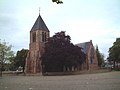
The medieval village church is the oldest building in Spijkenisse.

Windmill "Nooitgedacht" in Spijkenisse.

Mannetjes op de krom by Bert Kiewiet

The library "Bookmountain"
De Rokade
Maasboulevard


References
^ "Kerncijfers wijken en buurten" [Key figures for neighbourhoods]. CBS Statline (in Dutch). CBS. 2 July 2013. Retrieved 12 March 2014..mw-parser-output cite.citation{font-style:inherit}.mw-parser-output q{quotes:"""""""'""'"}.mw-parser-output code.cs1-code{color:inherit;background:inherit;border:inherit;padding:inherit}.mw-parser-output .cs1-lock-free a{background:url("//upload.wikimedia.org/wikipedia/commons/thumb/6/65/Lock-green.svg/9px-Lock-green.svg.png")no-repeat;background-position:right .1em center}.mw-parser-output .cs1-lock-limited a,.mw-parser-output .cs1-lock-registration a{background:url("//upload.wikimedia.org/wikipedia/commons/thumb/d/d6/Lock-gray-alt-2.svg/9px-Lock-gray-alt-2.svg.png")no-repeat;background-position:right .1em center}.mw-parser-output .cs1-lock-subscription a{background:url("//upload.wikimedia.org/wikipedia/commons/thumb/a/aa/Lock-red-alt-2.svg/9px-Lock-red-alt-2.svg.png")no-repeat;background-position:right .1em center}.mw-parser-output .cs1-subscription,.mw-parser-output .cs1-registration{color:#555}.mw-parser-output .cs1-subscription span,.mw-parser-output .cs1-registration span{border-bottom:1px dotted;cursor:help}.mw-parser-output .cs1-hidden-error{display:none;font-size:100%}.mw-parser-output .cs1-visible-error{font-size:100%}.mw-parser-output .cs1-subscription,.mw-parser-output .cs1-registration,.mw-parser-output .cs1-format{font-size:95%}.mw-parser-output .cs1-kern-left,.mw-parser-output .cs1-kern-wl-left{padding-left:0.2em}.mw-parser-output .cs1-kern-right,.mw-parser-output .cs1-kern-wl-right{padding-right:0.2em}
^ "Postcodetool for 3201EL". Actueel Hoogtebestand Nederland (in Dutch). Het Waterschapshuis. Retrieved 24 August 2013.
^ "Gemeente Spijkenisse". Spijkenisse.nl. Retrieved 2014-02-10.
^ Spijkenisse Online - geschiedenis Archived June 7, 2011, at the Wayback Machine.
External links
| Wikimedia Commons has media related to Spijkenisse. |
| Wikivoyage has a travel guide for Spijkenisse. |
- Official website
Places adjacent to Spijkenisse | ||||||||||
|---|---|---|---|---|---|---|---|---|---|---|
| ||||||||||


