Nihonbashi
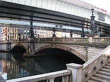
Nihonbashi (Nihon bridge)

Lion at the Nihonbashi

Kilometer Zero is on the middle of Nihonbashi.

Information plaque about the 'zero' point on the Nihonbashi
Nihonbashi (日本橋, "Japan Bridge") is a business district of Chūō, Tokyo, Japan which grew up around the bridge of the same name which has linked two sides of the Nihonbashi River at this site since the 17th century. The first wooden bridge was completed in 1603. The current bridge, designed by Tsumaki Yorinaka and constructed of stone on a steel frame, dates from 1911.[1] The district covers a large area to the north and east of the bridge, reaching Akihabara to the north and the Sumida River to the east. Ōtemachi is to the west and Yaesu and Kyobashi to the south.
Nihonbashi, together with Kyobashi and Kanda, is the core of Shitamachi[2], the original downtown center of Edo-Tokyo, before the rise of newer secondary centers such as Shinjuku and Shibuya.
Contents
1 History
2 Places in Nihonbashi
3 Companies based in Nihonbashi
4 Organizations based in Nihonbashi
5 Railway and subway stations
5.1 Subway stations
5.2 Railway stations
6 Neighboring post towns
7 Notes
8 External links
History
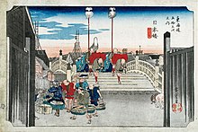
Ukiyo-e print of Nihonbashi by Hiroshige (The Fifty-three Stations of the Tōkaidō)

Ukiyo-e print of Nihonbashi by Keisai Eisen (The Sixty-Nine Stations of the Kiso Kaidō)

Nihonbashi in 1946

Kirin at the Nihonbashi
The Nihonbashi district was a major mercantile center during the Edo period: its early development is largely credited to the Mitsui family, who based their wholesaling business in Nihonbashi and developed Japan's first department store, Mitsukoshi, there. The Edo-era fish market formerly in Nihonbashi was the predecessor of the Tsukiji and Toyosu Markets. In later years, Nihonbashi emerged as Tokyo's (and Japan's) predominant financial district.
The Nihonbashi bridge first became famous during the 17th century, when it was the eastern terminus of the Nakasendō and the Tōkaidō, roads which ran between Edo and Kyoto. During this time, it was known as Edobashi, or "Edo Bridge." In the Meiji era, the wooden bridge was replaced by a larger stone bridge, which still stands today (a replica of the old bridge has been exhibited at the Edo-Tokyo Museum). It is the point from which all distances are measured to the capital; highway signs indicating the distance to Tokyo actually state the number of kilometers to Nihonbashi.
The area surrounding the bridge was burned to the ground during the massive March 9-10, 1945 bombing of Tokyo, considered the single largest air raid in history. Despite careful maintenance and restoration, one area of the bridge still has scars burned into the stone from an incendiary bomb. It is one of the few traces left from the fire bombing that leveled most of Tokyo.
Nihonbashi was a ward of Tokyo City. In 1947, when the 35 wards of Tokyo were reorganized into 23, it was merged with Kyobashi to form the modern Chuo ward.
Shortly before the 1964 Summer Olympics, an expressway was built over the Nihonbashi bridge, obscuring the classic view of Mount Fuji from the bridge.[3] In recent years, local citizens have petitioned the government to move this expressway underground. This plan was endorsed by Prime Minister Junichiro Koizumi in 2005, and the Tokyo Metropolitan Government and Ministry of Land, Infrastructure, Transport and Tourism announced in 2017 that they would begin a detailed study of the project, with a goal of beginning construction following the 2020 Summer Olympics in Tokyo.[4] If implemented, the construction costs are expected to total ¥500 billion (about US$4+ billion).[citation needed]
Places in Nihonbashi

Bank of Japan

Mitsukoshi Department Store

Nihonbashi Mitsui Tower
- Bank of Japan
Mitsukoshi and Takashimaya department stores
COREDO NIHONBASHI (ja)
Nihonbashi Mitsui Tower
Mandarin Oriental, Tokyo (ja)
- Tokyo Stock Exchange
Kilometre Zero for entire Japan
Companies based in Nihonbashi
Nihonbashi (日本橋)
Akebono Brake Industry[5]
Bank of America Merrill Lynch Japan
HSBC Japan
KOSÉ[6]
Kureha Corporation[7]
- Maruzen
Nisshinbo Holdings[8]
Nomura Holdings[9]
- Takashimaya
Takeda Pharmaceutical Company[10][11]
- Ippon Doll Works
Hakozakicho (箱崎町)
IBM Japan - IBM Hakozaki Facility
Honcho (本町)
Daiichi-Sankyo[12]
Muromachi (室町)
Mitsui Fudosan[13]
- Mitsukoshi
- Sembikiya
Shinsei Bank[14]
In the late 1990s GeoCities Japan was headquartered in the Nihonbashi Hakozaki Building in Hakozakicho.[15] At one time Creatures Inc. had its headquarters in the Kawasakiteitoku Building (川崎定徳ビル, Kawasakiteitoku Biru) in Nihonbashi.[16]
Organizations based in Nihonbashi
- Japan-India Association
Railway and subway stations
Subway stations
Bakuro-yokoyama Station (馬喰横山駅) - Toei Shinjuku Line (S-09)
Hamachō Station (浜町駅) - Toei Shinjuku Line (S-10)
Higashi-nihombashi Station (東日本橋駅) - Toei Asakusa Line (A-15)
Kayabachō Station (茅場町駅) - Tokyo Metro Hibiya Line (H-12), Tokyo Metro Tōzai Line (T-11)
Kodemmachō Station (小伝馬町駅) - Tokyo Metro Hibiya Line (H-14)
Mitsukoshimae Station (三越前駅) - Tokyo Metro Ginza Line (G-12), Tokyo Metro Hanzōmon Line (Z-09)
Nihombashi Station (日本橋駅) - Toei Asakusa Line (A-13), Tokyo Metro Ginza Line (G-11), Tokyo Metro Tōzai Line (T-10)
Ningyōchō Station (人形町駅) - Toei Asakusa Line (A-14), Tokyo Metro Hibiya Line (H-13)
Suitengūmae Station (水天宮前駅) - Tokyo Metro Hanzōmon Line (Z-10)
Railway stations
Bakurochō Station (馬喰町駅) - JR Sōbu Line (Rapid)
Shin-Nihombashi Station (新日本橋駅) - JR Sōbu Line (Rapid)
Neighboring post towns
As the starting point for the five routes of the Edo period, Nihonbashi provided easy access to many parts throughout ancient Japan.
Tōkaidō (connecting Edo to Kyoto, staying near the coast)
Nihonbashi (starting location) - Shinagawa-juku
Nakasendō (connecting Edo to Kyoto, going through the mountains)
Nihonbashi (starting location) - Itabashi-juku
Kōshū Kaidō (connecting Edo to Kai Province (modern-day Yamanashi Prefecture))
Nihonbashi (starting location) - Naitō Shinjuku
Ōshū Kaidō (connecting Edo to Mutsu Province (modern-day Fukushima Prefecture))
Nihonbashi (starting location) - Hakutaku-juku
Nikkō Kaidō (connecting Edo with Nikkō)
Nihonbashi (starting location) - Senju-juku
Notes
^ Guide Map/Nihonbashi Archived 2008-03-15 at the Wayback Machine.
^ Kokushi Daijiten Iinkai. Kokushi Daijiten (in Japanese). Vol. 4, page 842 (1983 ed.)..mw-parser-output cite.citation{font-style:inherit}.mw-parser-output q{quotes:"""""""'""'"}.mw-parser-output code.cs1-code{color:inherit;background:inherit;border:inherit;padding:inherit}.mw-parser-output .cs1-lock-free a{background:url("//upload.wikimedia.org/wikipedia/commons/thumb/6/65/Lock-green.svg/9px-Lock-green.svg.png")no-repeat;background-position:right .1em center}.mw-parser-output .cs1-lock-limited a,.mw-parser-output .cs1-lock-registration a{background:url("//upload.wikimedia.org/wikipedia/commons/thumb/d/d6/Lock-gray-alt-2.svg/9px-Lock-gray-alt-2.svg.png")no-repeat;background-position:right .1em center}.mw-parser-output .cs1-lock-subscription a{background:url("//upload.wikimedia.org/wikipedia/commons/thumb/a/aa/Lock-red-alt-2.svg/9px-Lock-red-alt-2.svg.png")no-repeat;background-position:right .1em center}.mw-parser-output .cs1-subscription,.mw-parser-output .cs1-registration{color:#555}.mw-parser-output .cs1-subscription span,.mw-parser-output .cs1-registration span{border-bottom:1px dotted;cursor:help}.mw-parser-output .cs1-hidden-error{display:none;font-size:100%}.mw-parser-output .cs1-visible-error{font-size:100%}.mw-parser-output .cs1-subscription,.mw-parser-output .cs1-registration,.mw-parser-output .cs1-format{font-size:95%}.mw-parser-output .cs1-kern-left,.mw-parser-output .cs1-kern-wl-left{padding-left:0.2em}.mw-parser-output .cs1-kern-right,.mw-parser-output .cs1-kern-wl-right{padding-right:0.2em}
^ Whiting, Robert, "Negative impact of 1964 Olympics profound", Japan Times, 24 October 2014, p. 14
^ "東京・日本橋、首都高を地下に 国交省と都が協議". 日本経済新聞 電子版 (in Japanese). Retrieved 2017-07-21.
^ "Corporate Profile." Akebono Brake Industry. Retrieved on February 15, 2017.
^ "Corporate Profile." KOSÉ. Retrieved on February 12, 2017.
^ "Corporate Profile." Kureha Corporation. Retrieved on November 21, 2018.
^ "Corporate Profile." Nisshinbo Holdings. Retrieved on February 13, 2017.
^ "Company Outline." Nomura Holdings. Retrieved on February 15, 2017.
^ "FAQ." Takeda Pharmaceutical Company. Retrieved on February 2, 2011. "Q : Where is Takeda located? A : [...] and the Tokyo Head Office is located in Tokyo, Japan."
^ "Overview." Takeda Pharmaceutical Company. Retrieved on February 2, 2011. "Tokyo Head Office 12-10, Nihonbashi 2-chome, Chuo-ku, Tokyo 103-8668"
^ "Company Information." Daiichi-Sankyo. Retrieved on February 15, 2017.
^ "Corporate Data." Mitsui Fudosan. Retrieved on February 15, 2017.
^ "Company Profile." Shinsei Bank. Retrieved on February 15, 2017.
^ "スタッフ募集." GeoCities Japan. February 21, 1999. Retrieved on April 30, 2009.
^ "Welcome to Creatures Inc." Creatures Inc. Retrieved on October 4, 2010. "東京都中央区日本橋3-2-5川崎定徳ビル別館5F."
External links
| Wikimedia Commons has media related to Nihonbashi, Tokyo. |
Coordinates: 35°41′02″N 139°46′28″E / 35.68389°N 139.77444°E / 35.68389; 139.77444
Authority control |
|
|---|


